Issue Date: May 9th, 2015
Issue Time: 10:10AM
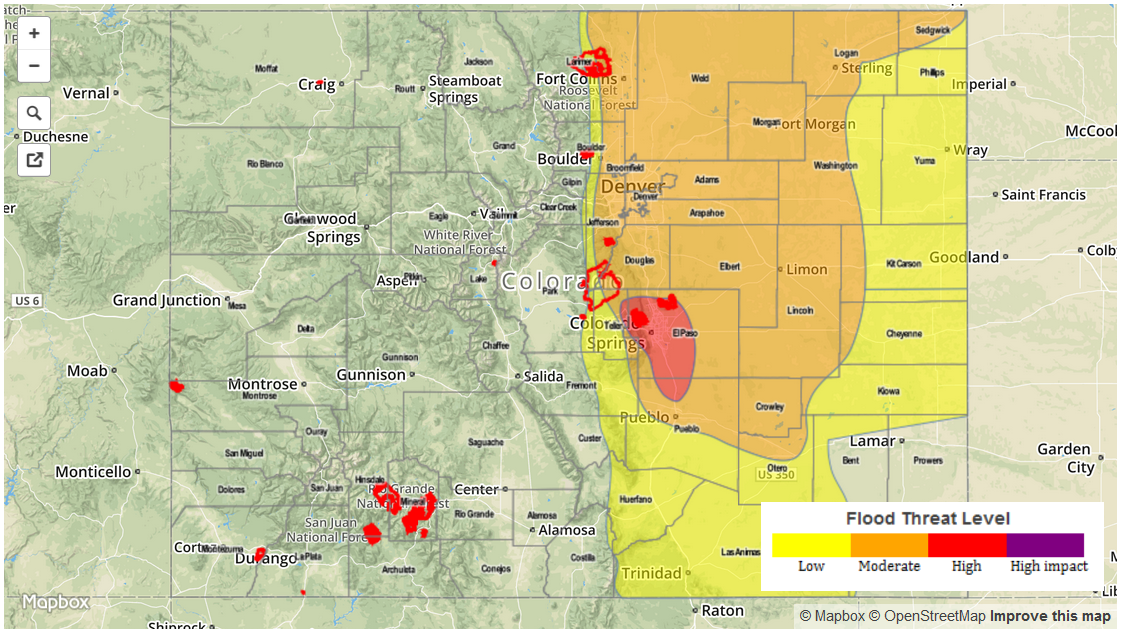
— HIGH flood threat for parts of Palmer Ridge
— MODERATE flood threat for Urban Corridor, Palmer Ridge, most of Northeast Plains and parts of Southeast Plains
— LOW flood threat for Raton Ridge, parts of Southeast Plains and Northeast Plains
The Mother’s Day weekend storm of 2015 is aimed directly at Colorado. What that means for today’s weather is a little bit of everything: heavy snowfall, high and persistent rainfall intensities and severe weather in the Southeast Plains where temperatures could soar into the upper 60s by late afternoon. The water vapor image below captures the main features of the state of the atmosphere. A partially cut-off low continues to march east-northeastward and is now located over the Four Corners region. An impressive disturbance is currently noted in eastern Colorado and clearly seen on the water vapor. This disturbance is accompanied by good low-level moisture convergence and is currently producing rain rates up to 1 inch per hour in Northeast Colorado. Across and west of the Continental Divide, the atmosphere has substantially cooled as the low-pressure draws near. The San Juan mountains are already seeing heavy snow, with isolated thunderstorms reported.
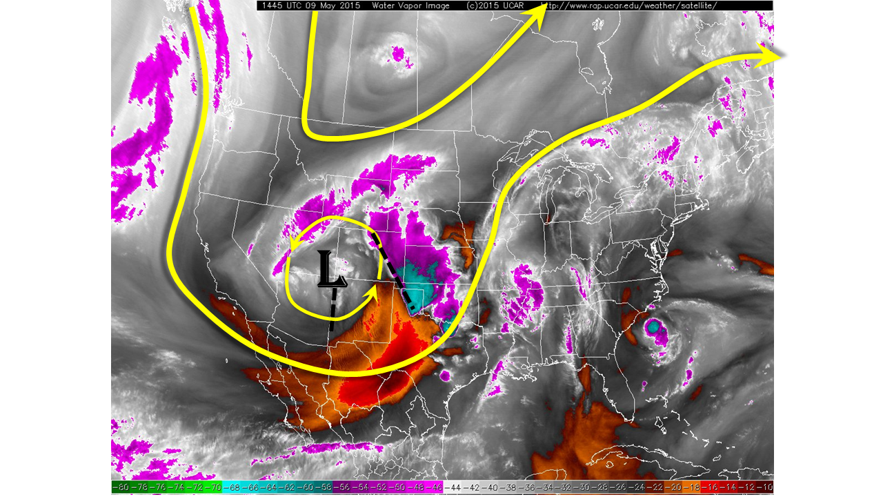
Regarding today’s forecast, rain and snow showers and thunderstorms will continue across most the state. Hourly rain rates will average around 0.5 inches, except in isolated heavy cells where 1.0 inch per hour rates are possible. Total 24-hour rainfall amounts of 1-2 inches will be widespread across Eastern Colorado, with isolated amounts up to 4 inches possible. In the San Juans, Central and Northern mountains, heavy snow will cause travel problems over the higher passes, where snowfall rates up to 1.5 to 2 inches an hour are likely.
Meanwhile, clouds are breaking along the New Mexico border, which will allow the May sun to quickly heat the atmosphere into the 60s and possibly 70F. As the upper-atmosphere cools, the combination of instability, high moisture content, good directional and speed shear may produce an outbreak of severe weather in the Southeast Plains. Large hail up to 2 inches, very strong winds up to 80 mph and tornadoes are all possible in the strongest of storms. The storms will race to the north around 50 mph, which will help to limit hourly rain rates to about 1.7 inches per hour. This may cause isolated flash flooding. The Prime Time for the severe weather is between 1PM and 8PM this evening.
We encourage everyone to pay attention to National Weather Service watches and warnings for heavy snowfall, flooding and severe weather updates throughout this active weather day.
Please see below for area-specific flood threat and forecasts (click on “About the FTB” link above to view Colorado region names).
Zone-Specific Forecasts
Urban Corridor, Front Range, Northeast Plains:
Showers and thunderstorms continuing throughout the day and into the late evening. An isolated strong storm is possible with some small hail. Rainfall rates of 0.5 inches per hour will be common, though stronger storms may produce rates up to 1 inch per hour. A Moderate flood threat has been posted for parts of the area due to saturated soils and high stream levels.
Prime time: 11AM through 10PM
Palmer Ridge, Southeast Plains, Raton Ridge and Southeast Mountains:
Scattered showers and storms this morning, redeveloping and strengthening in the afternoon, lasting into the late evening hours. Strong to severe storms will be likley from the afternoon through the late evening hours. Isolated rainfall rates up to 1.7 inches per hour are possible, accompanied by localized flash flooding. Large hail up to 2 inches, strong winds up to 80 mph and tornadoes are all possible with stronger storms. A High Flood threat is in place from Colorado Springs through Pueblo. Moderate and Low flood threats are also in place due to saturated soils.
Prime time: 1PM through 10PM