Issue Date: 7/25/2016
Issue Time: 9:15 AM
A LOW FLOOD THREAT IS ISSUED FOR PORTIONS OF THE NORTHEAST PLAINS, URBAN CORRIDOR, PALMER RIDGE, RATON RIDGE, FRONT RANGE, AND SOUTHEAST PLAINS.
A LOW FLOOD THREAT IS ALSO ISSUED FOR PORTIONS OF THE SAN JUAN MOUNTAINS AND SOUTHWEST SLOPE.
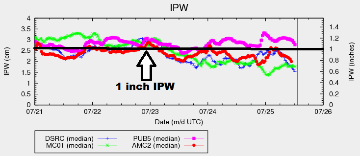
Behind the shortwave aloft that passed across the region yesterday, the upper-level ridge will build northward throughout the day today. The upper-high will become centered over the southern Rockies by this afternoon, with a jet max sitting across northern Colorado. Drier air has been filtering in from the west, and IPW values have decreased from yesterday afternoon’s values. 3 of the 4 normal reporting stations are below 0.8 inches IPW, while Pueblo holds on at just above 1 inch.
Generally speaking, with drier air filtering in and an upper-level ridge building overhead, this period will feature fewer showers and thunderstorms. Fighting against the drying, however, will be southeasterly surface flow across eastern Colorado, which will reinforce moisture this afternoon/evening. This will keep the threat of heavy rain in the forecast, albeit to a slightly lesser extent than yesterday. Additionally, enough moisture will hang on across southwest Colorado to keep the threat of locally heavy rain in the forecast for portions of the Southwest Slope and San Juan Mountains. Thus, the issuance of the low flood threat areas.
With southeasterly surface flow and northwest flow aloft over northeast Colorado, enough wind shear will be available to promote a couple isolated strong-to-severe storms this afternoon/evening. The main threats will be hail (up to 1.5 inches in diameter) and strong winds (gusts up to 65 mph), with periods of heavy rainfall. The most likely locations for this activity will be along and near the Cheyenne Ridge, and adjacent locations to the southeast. For more information on timing and rain rates across the state, please see the zone-specific forecast discussions below.
Today’s Flood Threat Map
For more information on today’s flood threat, see the map below (hover over threat areas for more details). For Zone-Specific forecasts, jump below the map.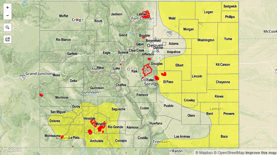

Zone-Specific Forecasts
Urban Corridor, Northeast Plains, Palmer Ridge, Southeast Plains, and Raton Ridge:
Isolated-to-widely scattered showers/storms, with the best coverage occurring adjacent to the higher elevations and along/near the preferred terrain of the Cheyenne Ridge, Palmer Ridge, and Raton Ridge. A couple storms will be severe, mainly over the Northeast Plains, namely Weld, Morgan, Logan, and Washington counties. Strong-to-severe storms will be capable of producing hail, lightning, strong winds, and periods of heavy rainfall. Maximum rain rates are as follows:
Urban Corridor: 0.8-1.2 inches/hour
Palmer Ridge: 1.0-1.5 inches/hour
Northeast Plains and Southeast Plains: 1.5-2.5 inches/hour
Raton Ridge: 0.8-1.2 inches/hour
Timing: Noon – 10 PM, with a few storms continuing until midnight/1 AM.
Front Range, San Luis Valley, and Southeast Mountains:
Isolated showers/thunderstorms expected, with the best coverage across southern portions of the Front Range and across the Southeast Mountains where moisture will be best. The San Luis Valley will be mostly sunny, with the one or two storms moving overhead from the surrounding higher terrain. Maximum rain rates are as follows:
Front Range: 0.8-1.2 inches/hour
Southeast Mountains: 0.6-0.8 inches/hour
San Luis Valley: 0.4-0.8 inches/hour
Timing: 11 AM – 11 PM for the mountains, 1 PM – 9 PM for San Luis Valley
Northwest Slope, Northern Mountains, Central Mountains, and Grand Valley:
Isolated, garden variety showers/storms will interrupt the otherwise hot and mostly sunny day across the area. Storms will favor the higher terrain, and only briefly move over adjacent lower valleys. The main threats from storm activity will be gusty winds and lightning, with light-to-moderate rainfall. Maximum rain rates are as follows:
Northwest Slope: 0.1-0.3 inches/hour
Northern Mountains: 0.2-0.5 inches/hour
Central Mountains and Grand Valley: 0.3-0.6 inches/hour
Timing: Noon – 10 PM
San Juan Mountains and Southwest Slope:
Scattered showers/thunderstorms are expected, with the main threats being gusty winds, lightning, and brief periods of moderate-to-heavy rainfall. The higher terrain will be favored, with storms only briefly drifting over adjacent valleys. Maximum rain rates will be 0.8-1.25 inches/hour.
Timing: 11 AM – 11 PM, with primetime for heavy rainfall threat between Noon and 8 PM.