Issue Date: 7/24/2016
Issue Time: 9:51 AM
A MODERATE FLOOD THREAT IS FORECAST FOR PORTIONS OF THE URBAN CORRIDOR, PALMER RIDGE, SOUTHEAST PLAINS, NORTHEAST PLAINS, AND FRONT RANGE.
A LOW FLOOD THREAT IS FORECAST FOR SURROUNDING AREAS, INCLUDING PORTIONS OF THE NORTHERN MOUNTAINS, CENTRAL MOUNTAINS, SOUTHEAST MOUNTAINS, RATON RIDGE, AND SAN JUAN MOUNTAINS.
The current water vapor analysis (below) shows two main features of note: a shortwave tracking across the northern US, and a strong upper-level high across the southern US. The shortwave trough has flattened the ridge and turned the flow aloft to a more westerly direction, which will continue to shift drier air into Colorado from the west. Ahead of this dry air, however, the plume of subtropical air is still situated across Colorado. The moisture aloft will, in itself, provide fuel for scattered showers and thunderstorms, but it is what is occurring at the surface that will drive the low-to-moderate flood threat.
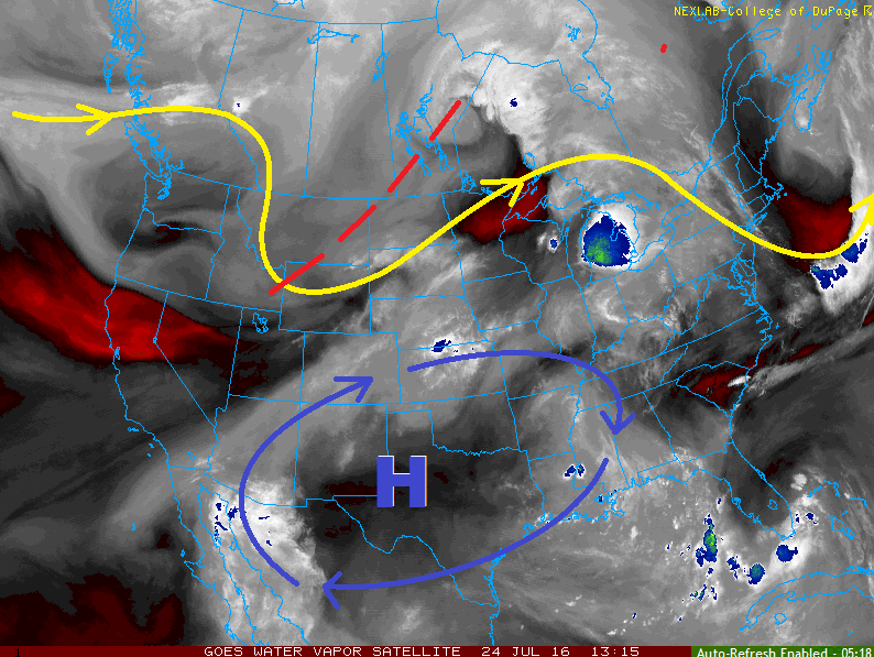
A surface cool front has moved into Northeast Colorado this morning, and will settle along/near the Palmer Ridge this afternoon. North of the front temperatures will be 5-10 degrees cooler than yesterday, and south of the front temperatures will be comparable to yesterday. More importantly for our product is that behind the cool front, moist upslope flow has developed, deepening the moisture available to showers and thunderstorms. IPW values will climb near/above one inch along the Front Range and eastward across the plains during the afternoon and evening hours. Additionally, the cool front will provide a focus for thunderstorm development, and storms anchoring to, or near, this boundary will present both a severe threat and an enhanced heavy rain threat.
Also, as the winds turn southeast behind the front and across the Palmer Ridge, a Denver Cyclone is expected to develop. This will place Douglas and Elbert Counties under the gun for strong/severe thunderstorms producing heavy rain. These areas have been included in the moderate flood threat. Along and west of the Continental Divide, scattered showers/thunderstorms are expected again today, mainly over the higher terrain. Westerly flow aloft will allow storms to move over lower valleys.
Today’s Flood Threat Map
For more information on today’s flood threat, see the map below (hover over threat areas for more details). For Zone-Specific forecasts, jump below the map.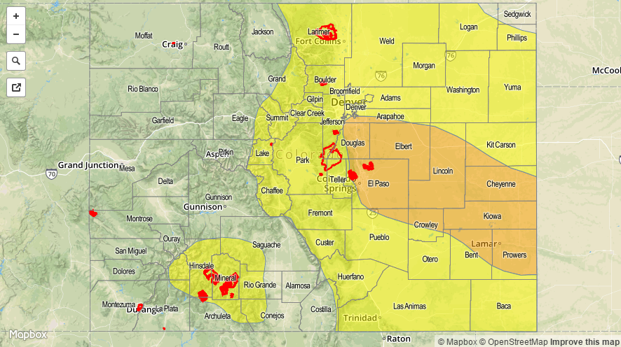

Zone-Specific Forecasts
Urban Corridor, Palmer Ridge, Raton Ridge, Northeast Plains, and Southeast Plains:
Scattered showers and thunderstorms are expected, with a few becoming strong/severe. For reasons outlined in the discussion above, the low-to-moderate flood threat is warranted. Training storms along the cool front/Denver Cyclone are a concern, and those concerns have been taken into consideration by the moderate flood threat area. Maximum rain rates are as follows:
Urban Corridor and Palmer Ridge: 1.5-2.0 inches/hour
Southeast Plains and Southeast Plains: 2.0-3.0 inches/hour
Raton Ridge: 1.0-1.6 inches/hour
Timing: 1 PM – 9 PM for most, with scattered thunderstorms continuing across the Southeast Plains and eastern portions of the Palmer Ridge/Raton Ridge until Midnight.
Front Range, Southeast Mountains, Northern Mountains, San Juan Mountains, Central Mountains, Southwest Slope, Northwest Slope, Grand Valley, and San Luis Valley:
Isolated-to-scattered showers and thunderstorms are expected, mainly over the higher terrain. The best coverage will occur across the San Juan Mountains, Central Mountains, Front Range, and Southeast Mountains, with lesser coverage elsewhere. The Northwest Slope and Grand Valley will see the least amount of activity today as drier air aloft continues to move in. Maximum rain rates are as follows:
Front Range and Southeast Mountains: 0.8-1.4 inches/hour
Northern Mountains, Central Mountains, and San Juan Mountains: 0.6-1.2 inches/hour
Northwest Slope and Grand Valley: 0.2-0.5 inches/hour
San Luis Valley: 0.4-0.8 inches/hour
Timing: 11 AM – 10 PM, with a few lingering showers/storms over southern mountains/San Luis Valley into the early morning hours.