Issue Date: May 8th, 2015
Issue Time: 10:55AM
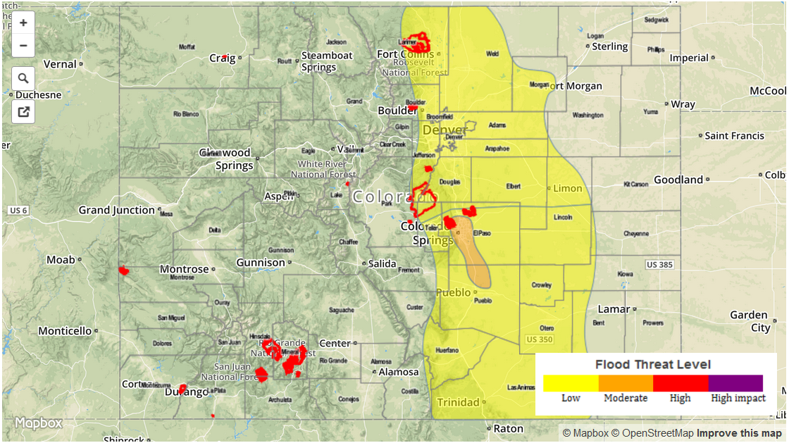
— Moderate flood threat for parts of Palmer Ridge
— Low flood threat for Front Range, Urban Corridor, Palmer Ridge, Southeast Mountains and parts of Northeast Plains and Southeast Plains
An already active weather pattern is about to get even more active across Colorado. The water-vapor image below shows the key players in the atmosphere today. A cut-off upper-level low pressure system is centered over Southern California this morning. It accounted for much needed rainfall over California and is now progressing east-northeastward towards Colorado. Within its flow, two additional disturbances are noted this morning, as shown by the dotted black lines. The first disturbance, already halfway across Colorado, is accounting for showers and isolated thunderstorms stretching from the Northwest Slope southeast through the Palmer Ridge regions. This disturbance is confirmed by visible satellite imagery showing a boundary between cloudy skies to its northeast and sunny to partly cloudy skies to the southwest. A second disturbance over Utah and Nevada will progress eastward and reignite shower and thunderstorm activity across Colorado later this afternoon.
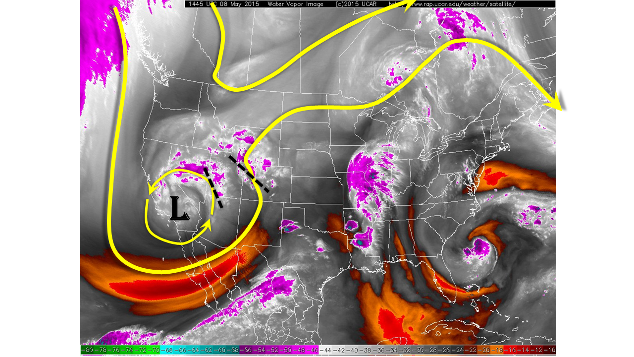
As has been the case all week, precipitable water (PW) values continue to run high east of the Continental Divide, with this morning’s numbers coming in between 0.7 and 0.8 inches. As the low-pressure system approaches from the east it is likely that higher PW values will be transported into Colorado from the southeast. PWs of 0.9 inches will be possible across the Southeast Plains region, which will help maintain a heavy rain threat. Another factor to consider in today’s flood threat is the high amounts of antecedent rainfall that have occurred over the past 7 days. Soils are either saturated or close to it across most of the Palmer Ridge and Urban Corridor and even the Grand Valley regions where weekly rainfall amounts of 2 to as high as 6 inches have occurred. Furthermore, several rivers, notably the South Platte and Fountain Creek continue to slowly rise and are approaching or already in “Action” levels (note that the “Action” level is the precursor to a “Minor flooding” level).
Taking all the factors together, today’s forecast is for the ongoing shower and storm activity to continue with more redevelopment in the afternoon. A Low flood threat is once again in place along the entire length of the I-25 corridor. Afternoon thunderstorm activity in the Southeast Plains may contain strong to severe thunderstorms capable of producing winds up to 60 mph, hail up to 2 inches in diameter and heavy rainfall up to 1.7 inches per hour. A Moderate flood threat has been posted over the Palmer Ridge for Fountain Creek due to elevated streamflow and more rainfall on the way.
As the main flood threat begins to subside later this evening, rain will change to snow overnight with snow levels slowly dropping to about 7,000 feet by Saturday. For the second year in a row, we will likely see a significant Mother’s Day snowstorm over the higher terrain.
Please see below for area-specific forecasts (click on “About the FTB” link above to view Colorado region names).
Urban Corridor, Front Range, Northeast Plains:
Showers and isolated thunderstorms continuing into the afternoon and early evening. An isolated strong storm is possible with some small hail. Rainfall rates will generally stay lighter than 0.5 inches per hour. A Low flood threat has been posted for parts of the area due to saturated soils. The South Platte River needs to be watched from Denver through Fort Morgan as it is approaching “Action” levels in many gages with more rainfall on the way.
Prime time: Noon through 8PM
Palmer Ridge, Southeast Plains, Raton Ridge and Southeast Mountains:
Showers and storms ending later this morning, but redeveloping in the afternoon and lasting into the late evening hours. Strong to severe storms will be possible from the afternoon through the late evening hours. Isolated rainfall rates up to 1.7 inches per hour are possible, accompanied by localized flash flooding. A Flood Advisory is already in place west of Colorado Springs this morning, prompting a Moderate flood threat from Colorado Springs down to the Arkansas River. A Low flood threat is in place elsewhere.
Prime time: 1PM through 10PM
Central Mountains, San Juan Mountains, San Luis Valley and Southwest Slope:
Partly cloudy skies this morning with showers and perhaps a weak thunderstorm developing in the early afternoon. Rainfall rates will stay below 0.4 inches per hour. No flood threat is expected. Later this evening, rain will transition into snow with snow levels dropping into the higher valleys overnight.
Northwest Slope, Grand Valley, and Northern Mountains:
Ongoing showers this morning with more redevelopment in the afternoon. An isolated thunderstorm cannot be ruled out. Rain rates will stay below 0.3 inches and hour. Despite the rainfall over the past few days, no flood threat is expected due to the light rainfall intensity today. Rainfall will increase in coverage overnight as a disturbance approaches from the west. Rain will turn into snow in the higher elevations, with snow levels dropping overnight.