Issue Date: Monday, June 20th, 2016
Issue Time: 10:45AM MDT
— MODERATE flood threat for parts of the Front Range, Urban Corridor, Palmer Ridge, Southeast Plains and Southeast Mountains
— LOW flood threat for parts of Northeast Plains, Central Mountains and Raton Ridge
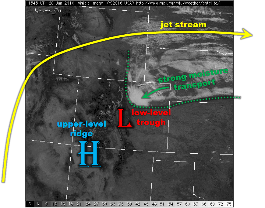
Today’s visible satellite imagery, below, shows a rather small-scale but nonetheless impressive plume of low-level moisture being transported in from Nebraska. Despite the presence of a stout upper-level ridge, centered over southern Colorado, it is often said the higher terrain such as the 14ers that our state sports can generate its own circulation. Today will be an excellent example of this. As the plume of moisture, with Precipitable Water values as high as 1.3 inches makes it upslope over the Palmer Ridge, strong elevated heating will generate a strong cyclonic circulation in the lowest ~8,000 feet of the atmosphere. This will set the stage for plenty of instability for scattered to widespread thunderstorms. Heavy rainfall will be likely today over the higher elevations of the southern Front Range and western Palmer Ridge. Furthermore, slow wind speeds will favor slow storm motion, while deep easterly flow will contribute to the possibility of training where repeated cells pass over the same area twice. A Moderate flood threat has been issued for the Palmer Ridge, with a Low threat for surrounding areas. Of particular concern will be fire scars, such as the fresh “TA-27” fire scar in El Paso County.
Today’s Flood Threat Map
For more information on today’s flood threat, see the map below (hover over threat areas for more details). For Zone-Specific forecasts, scroll below the map.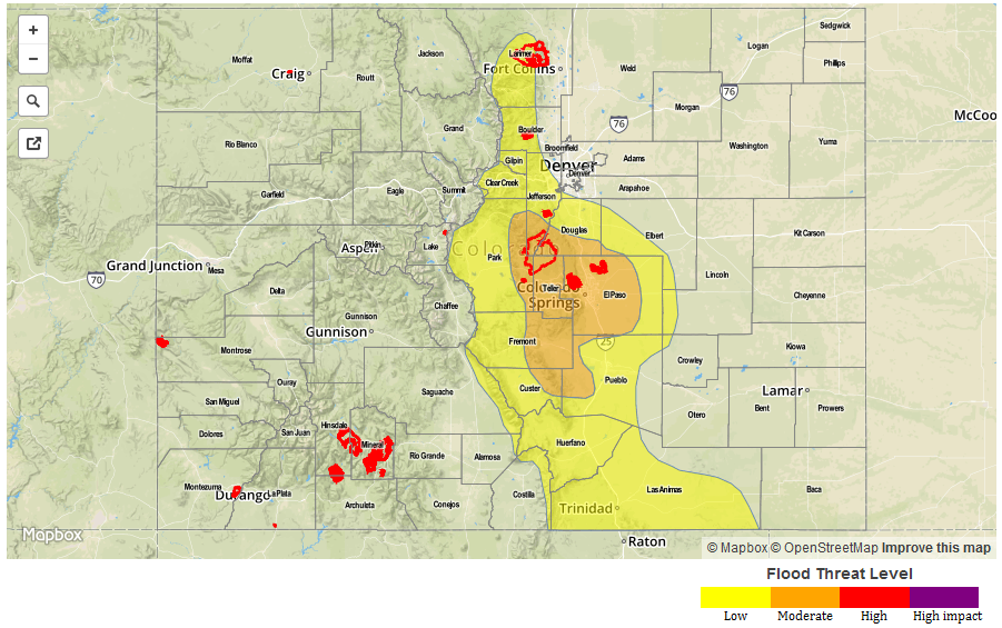
Zone-Specific Forecasts:
Urban Corridor, Northeast Plains, Palmer Ridge, Southeast Plains, Southeast Mountains, Raton Ridge, Front Range, Central Mountains:
Partly cloudy early, then scattered to widespread showers and thunderstorms developing over the higher terrain. Slow storm motion and training of cells could result in several hours of heavy rainfall activity at a given location. Fire scars are extremely vulnerable today, especially in light of recent burn activity. Primetime and max 1-hour rain rates are:
Palmer Ridge, Front Range and Urban Corridor: 1-hr max rain rates up to 1.8 inches, 3-hour max up to 2.8 inches. Primetime: 12pm – 11pm
Northeast Plains, Southeast Plains, Southeast Mountains, Raton Ridge and Central Mountains:
1-hr max rain rates up to 1.6 inches, 3-hour max up to 2.4 inches. Primetime: 12pm – 1am
San Juan Mountains, San Luis Valley, Northern Mountains, Grand Valley, Northwest Slope, Southwest Slope:
Sunny and continued very warm today with above average temperatures as high as 100F possible in the lower elevations of the Grand Valley. There is a slight chance of showers and weak thunderstorms in the San Juans, but 24-hour rainfall will stay below 0.5 inches. Flooding is not expected today.