Issue Date: 5/26/2016
Issue Time: 10:30 AM
A MODERATE FLOOD THREAT IS FORECAST FOR PORTIONS OF THE FRONT RANGE, URBAN CORRIDOR, PALMER RIDGE, SOUTHEAST PLAINS AND NORTHEAST PLAINS REGIONS.
A LOW FLOOD THREAT ENCOMPASSES THE MODERATE FLOOD THREAT, AND INCLUDES PORTIONS OF THE NORTHERN MOUNTAINS, CENTRAL MOUNTAINS, SOUTHEAST MOUNTAINS, RATON RIDGE, AND SOUTHEAST PLAINS.
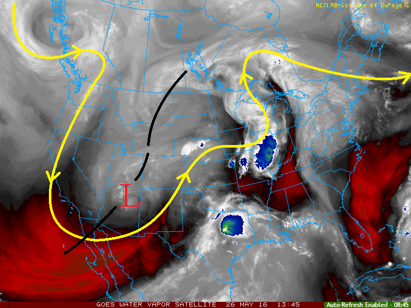
Current analysis of the atmosphere shows the upper-level low centered over northern Arizona, and a surface low centered over the OK/TX panhandles. A surface boundary extends from the surface low center back across the Southeast Plains, and then northward along the Front Range. South of the boundary, the air is a bit drier with dewpoints in the 20s and 30s. To the north of the boundary, dewpoints are in the 40s and 50s.
The upper-level low will move east-northeastward throughout the day today, reaching southeast Colorado by tonight. The surface low will continue to transport moisture into eastern Colorado from the central US plains. This moist, upslope flow, combined with upper-level support and steep lapse rates, will support strong-to-severe thunderstorms today/tonight over portions of the Northern Mountains, Central Mountains, Front Range, Northeast Plains, Southeast Plains, Palmer Ridge, and Raton Ridge regions.
To the west, scattered showers and thunderstorms are expected as broad-scale support spreads overhead. The higher elevations will be favored for thunderstorm activity, but a few will drift over lower valleys. Low-level moisture will be a bit on the low side, so showers/thunderstorms will remain high-based; rain rates will be tempered. Gusty winds, lightning, and small hail will be the main threats from stronger storms (relatively speaking). The highest peaks will likely see a couple inches of snow, while most areas receive rainfall.
For more information regarding timing, rain rates, and impacts, please see the zone-specific discussions below.
Today’s Flood Threat Map
For more information on today’s flood threat, see the map below (hover over threat areas for more details). For Zone-Specific forecasts, jump below the map.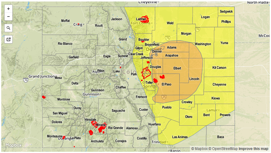

Zone-Specific Forecasts
Urban Corridor, Northeast Plains, Palmer Ridge, Southeast Plains, and Raton Ridge:
Scattered thunderstorms are expected today for all areas. Some of the thunderstorms will become strong-to-severe, with the main threats being large hail, lightning, and a couple tornadoes. Moderate-to-heavy rainfall is also expected, thus the issuance of the low-to-moderate flood threat. The threat will continue into the nighttime hours for all regions, but especially over the Palmer Ridge, Urban Corridor, and western portions of the Southeast Plains regions due to north-northeasterly low-level flow favoring persistent showers/thunderstorms in those locations. Maximum rain rates will be 1.5-2.2 inches/hour across all regions. Overall, the flood threat will peak this afternoon and evening, but will remain in effect throughout the period. Scattered showers/thunderstorms will continue overnight and into tomorrow morning.
Timing: 11 AM – 11 AM Friday
Northern Mountains, Central Mountains, Front Range, and Southeast Mountains:
Scattered showers and thunderstorms are expected. A couple will become strong-to-severe, with the main threats being hail, lightning, and damaging winds. Moderate-to-heavy rain will also attend stronger storms, with maximum rain rates varying:
Northern Mountains and Central Mountains: 0.8-1.4 inches/hour
Front Range and Southeast Mountans: 1.2-1.8 inches/hour
The Waldo Canyon Burn Scar will need to be monitored closely today/tonight.
Scattered showers and thunderstorms will continue through the overnight hours and into tomorrow morning, mainly across the Front Range and Southeast Mountains.
Timing: 11 AM – 11 AM Friday
Northwest Slope, Grand Valley, Southwest Slope, San Juan Mountains, and San Luis Valley:
Scattered showers and thunderstorms expected throughout the day and into the nighttime hours. Coverage will peak during the late afternoon/early evening, and most storms will have ended by Midnight. A few isolated showers over the higher terrain will linger into tomorrow morning. Maximum rain rates will be 0.4-0.7 inches/hour. The highest elevations will receive a couple inches of snow.
Timing: 11 AM – Midnight, with a few lingering into the morning