Issue Date: 5/25/2016
Issue Time: 9:55 AM
NO FLOOD THREAT IS FORECAST.
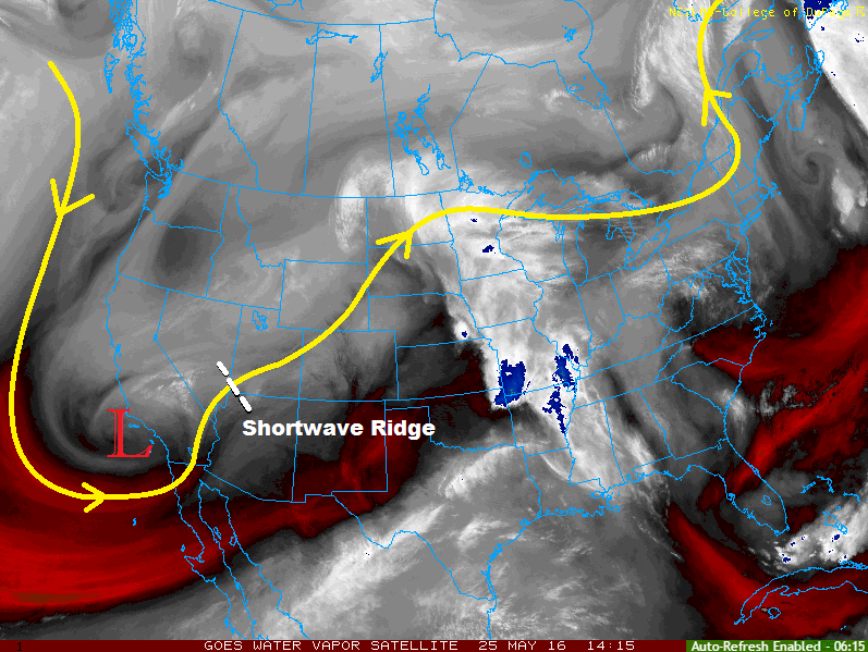
A shortwave ridge (depicted in the water vapor image below) will move overhead today, which will bring subsidence aloft. The ridge will be largely responsible for the drying/warming trend across the state through this period. There will be a few exceptions, and we will get to that below. Generally speaking, though, today will be a very pleasant day across Colorado. Overnight, changes start knocking on the doorstep and set the stage for unsettled weather on Thursday.
There will be a couple isolated showers/weak thunderstorms over the Northwest Slope, Northern Mountains, and Front Range regions today, owing to a nearby 700-mb trough axis and associated moisture oriented SW to NE across the intermountain west. Further south, orographic effects may be able to produce one or two isolated showers/weak thunderstorms over the higher terrain of the San Juan Mountains, but those probabilities are low. Overall, high country regions other than the Northwest Slope, Northern Mountains, and Front Range will remain mostly sunny and dry, with gusty winds. Overnight and during the early morning hours tomorrow, as the ridge moves out of the area and the upper-level low draws nearer, a few isolated showers/weak thunderstorms will develop over the higher terrain.
For the lower elevations of eastern Colorado, today will feature mostly sunny conditions with high temperatures ranging from the mid/upper 70s to upper 80s (in the far Southeast Plains). With surface dewpoints hanging on in the 40s and 50s this morning, a couple isolated thunderstorms will develop this afternoon/evening across the Urban Corridor, Palmer Ridge, and Northeast Plains. Overnight, a cool front will begin to push southward across the Northeast Plains, bringing an isolated thunderstorm or two.
Today’s Flood Threat Map
For more information on today’s flood threat, see the map below (hover over threat areas for more details). For Zone-Specific forecasts, jump below the map.

Zone-Specific Forecasts
Urban Corridor, Northeast Plains, Palmer Ridge, Southeast Plains, and Raton Ridge:
Mostly sunny with high temperatures a few degrees warmer than yesterday. A couple isolated thunderstorms will develop this afternoon and evening as a result of daytime heating working on remaining surface moisture. The regions with the best chance of seeing isolated thunderstorms, relatively speaking, will be the Palmer Ridge and Northeast Plains. The Southeast Plains and Raton Ridge will remain dry. Maximum rain rates are as follows:
Urban Corridor: 0.15-0.25 inches/hour
Northeast Plains and Palmer Ridge: 0.3-0.5 inches/hour
Southeast Plains and Raton Ridge: N/A
Overnight and into the early morning hours tomorrow, a cool front will move southward through northeast Colorado, kicking up a couple isolated showers/weak thunderstorms. Rain rates in these storms will generally be 0.3-0.6 inches/hour.
Northern Mountains, Northwest Slope, and Front Range:
Isolated showers/weak thunderstorms are expected this afternoon and evening, producing mainly light rain, gusty winds, and occasional lightning. A few isolated showers/storms will develop during the overnight/early morning hours over the higher terrain in response to the approaching upper-level low. Maximum rain rates will be 0.15-0.25 inches/hour.
Timing: 11 AM – 8 PM
Central Mountains, Grand Valley, Southeast Mountains, Southwest Slope, San Juan Mountains, and San Luis Valley:
The main weather story today will be the mostly sunny skies and occasionally breezy conditions. One or two isolated showers/weak thunderstorms are possible over the higher terrain of the San Juan Mountains this afternoon, but those probabilities are very low. A couple isolated showers/weak thunderstorms will develop over the higher terrain during the early morning hours tomorrow in response to the approaching upper-level low, setting the stage for tomorrow’s unsettled weather.