Issue Date: 5/11/2016
Issue Time: 9:42 AM
A LOW FLOOD THREAT CONTINUES FOR THE CACHE LA POUDRE RIVER FOR LOW-LYING AREAS.
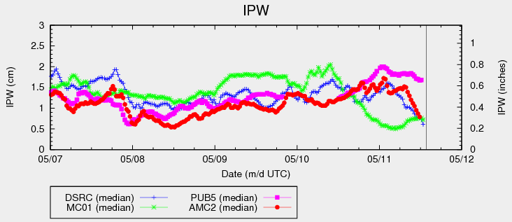
An upper-level trough will slowly move eastward across the Northern Rockies/Great Plains today, with a disturbance rounding the base of the trough and across Colorado this afternoon/evening. This disturbance will help kick off another round of showers/thunderstorms today, albeit in less numbers than previous days. Coverage will be isolated overall, with more scattered coverage expected across the Palmer Ridge, Southeast Plains, and Raton Ridge regions. The IPW chart more or less bears this out, showing better moisture in place at the Pueblo station (pink like), with moisture taking a dip from yesterday at the Grand Junction, Shriever AFB, and Boulder stations.
No flood threat is warranted from thunderstorm activity today, as instability values will be low and moisture has been lessened from previous days. However, there is potential for a stronger storm or two across the Palmer Ridge, Raton Ridge, and Southeast Plains; shear and instability will be best here. At any rate, the threat from the strongest storms will be lightning, gusty winds, small hail, and brief moderate-to-heavy rainfall. Precipitation will come to an end tonight across most regions as ridging/drier air works into the state, with only a few lingering showers remaining over the Southeast Plains/Raton Ridge into early tomorrow morning.
For a breakdown on what to expect in each region, see the region-specific forecast discussions below.
Today’s Flood Threat Map
For more information on today’s flood threat, see the map below (hover over threat areas for more details). For Zone-Specific forecasts, jump below the map.

Zone-Specific Forecasts
Urban Corridor, Southeast Plains, Palmer Ridge, Raton Ridge, and Northeast Plains:
Scattered showers and thunderstorms expected this afternoon and evening, mainly along and south of I-70. An isolated shower/weak thunderstorm or two will occur north of there. The main threats from any stronger thunderstorm will be small hail, lightning, gusty winds, and brief moderate-to-heavy rainfall. Rain rates will generally be light in the 0.2-0.4 inches/hour range. Maximum rain rates from thunderstorms will be 0.4-0.7 inches/hour, mainly across the Palmer Ridge, Southeast Plains, and Raton Ridge.
Activity will diminish during the late evening/overnight hours from north-to-south and west-to-east. Only a couple showers will linger into the early morning hours across the Southeast Plains/Raton Ridge.
Primetime: 11 AM – 11 PM
Front Range, Northwest Slope, Northern Mountains, Grand Valley, Central Mountains, and Southwest Slope:
Isolated showers and weak thunderstorms are expected over the higher terrain this afternoon and early evening. Subsidence and drying will move in during the nighttime hours bringing an end to activity. Rain rates will be low (0.1-0.25 inches/hour).
Timing: 11 AM – 8 PM
San Juan Mountains, Southeast Mountains and San Luis Valley:
Isolated-to-widely scattered showers/weak thunderstorms are expected, mainly over the higher terrain. The San Luis Valley will largely miss out on any precipitation. Activity will mostly come to an end during the late evening/overnight hours. Rain rates will be low, ranging from 0.15-0.3 inches/hour.
Timing: 11 AM – 10 PM, with a few lingering showers into the early morning hours.