Issue Date: 5/10/2016
Issue Time: 9:58 AM
A LOW FLOOD THREAT IS FORECAST FOR PORTIONS OF THE NORTHEAST PLAINS, SOUTHEAST PLAINS, AND PALMER RIDGE. A LOW FLOOD THREAT CONTINUES FOR THE CACHE LA POUDRE RIVER FOR LOW-LYING AREAS.
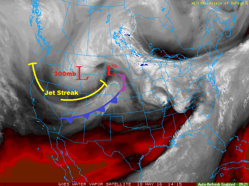
On top of this morning’s water vapor image, I have labeled the approximate locations of a couple key features to this period’s forecast. The Low labeled “300 mb” is the upper-level low center, “jet streak” is the location of the upper-level jet streak, and the low labeled as “Sfc” is the surface low center. The cool front is currently draped across Colorado, back into northern AZ, and will not move southward much through the day today, with the boundary finally pushing out of the state around midnight tonight.
Overall, as the jet streak sinks to the south in response to the upper-level low drifting southward, the best large-scale lift will reside along (and south of) a corridor from the Southwest Slope to the southern half of the Northeast Plains. This area of “best” lift will sit overtop the cool front boundary and upslope flow regions, providing a focus for the most shower/thunderstorm activity. A few strong thunderstorms are possible across the Palmer Ridge, southern portions of the Northeast Plains, and northern portions of the Southeast Plains. These locations are outlined by the low flood threat area.
Over the mountains this afternoon/evening, showers and weak thunderstorms will mainly be focused along the frontal boundary and over the higher terrain south of I-70. One or two showers/weak thunderstorms could develop over the higher terrain of the Northern Mountains as daytime heating warms the mountains, but not much is expected due to unfavorable upper-level conditions.
Overnight, activity will end from north to south as the front exits and upper-level subsidence takes over. However, a few will linger into the morning hours across the southern half of Colorado until the subsidence arrives.
Today’s Flood Threat Map
For more information on today’s flood threat, see the map below (hover over threat areas for more details). For Zone-Specific forecasts, jump below the map.

Zone-Specific Forecasts
Urban Corridor, Southeast Plains, Palmer Ridge, Raton Ridge, and Northeast Plains:
Isolated-to-scattered showers/thunderstorms, mainly south of I-76 and north of Highway 50. A couple storms will become strong-to-marginally severe across the Palmer Ridge, northern portions of the Southeast Plains, and southern portions of the Northeast Plains. Rain rates will generally be light (0.1-0.3 inches/hour) except for under strong thunderstorms, where maximum rain rates will push 1.6-2.0 inches/hour. Dry air underneath the thunderstorms will limit that somewhat, and storm motions will help mitigate the flood threat, as well. Thus, only a low flood threat is warranted.
Timing: 11 AM – 8 PM, with a few lingering into the overnight/early morning hours
Front Range, Grand Valley, Northwest Slope, and Northern Mountains:
Isolated showers and weak thunderstorms possible north of I-70, with more widely scattered coverage to the south. The Northwest Slope will be the driest region during this period, overall. Rain rates will generally be light at 0.1-0.2 inches/hour, with thunderstorms over the Front Range producing the best rain rates at 0.2-0.4 inches/hour.
Timing: 11 AM – 10 PM
Central Mountains, San Juan Mountains, Southwest Slope, Southeast Mountains and San Luis Valley:
The higher terrain along the frontal zone will be favored for scattered showers and thunderstorms throughout the period, with isolated showers/weak thunderstorms elsewhere. Rain rates will generally be light, with maximum rain rates of 0.15-0.3 inches/hour. Activity will largely diminish overnight, but a few isolated showers will linger until around midnight near the southern CO border.
Timing: 11 AM – 10 PM