Issue Date: 9/23/2015
Issue Time: 9:08 AM
A LOW FLOOD THREAT IS FORECAST FOR PORTIONS OF THE SAN JUAN MOUNTAINS, SOUTHWEST SLOPE, SOUTHEAST MOUNTAINS, RATON RIDGE, SOUTHEAST PLAINS, NORTHEAST PLAINS, AND PALMER RIDGE REGIONS.
The first day of Fall will bring a second consecutive day of unsettled weather to most of Colorado; the Northwest Slope and Grand Valley regions will be the exceptions, where dry conditions will welcome the official changing of the seasons. Elsewhere, ample moisture and favorable dynamics will allow for isolated-to-scattered showers and thunderstorms to develop this afternoon and evening, producing mainly light-to-moderate rainfall, gusty winds, and some lightning.
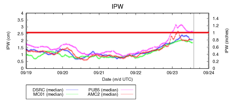
A few storms will be capable of producing heavy rainfall, thanks to the amount of mid-level moisture present from the remnants of tropical disturbance (see IPW chart above) and ample moisture available in the low-levels (surface dewpoints are in the 50s and 60s across eastern Colorado). The locations that are most likely to be impacted by heavy rainfall have been included in the low flood threat area. For more information on rain rates and timing, please see the zone-specific discussions below.
Today’s Flood Threat Map
For more information on today’s flood threat, see the map below (hover over threat areas for more details). For Zone-Specific forecasts, jump below the map.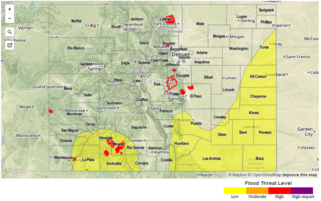
Zone-Specific Forecasts
Northwest Slope and Grand Valley:
Partly cloudy early becoming mostly sunny later, with high temperatures a few degrees warmer than yesterday. No precipitation expected.
Northern Mountains, Front Range, Southeast Mountains, Central Mountains, San Luis Valley, San Juan Mountains, and Southwest Slope:
Isolated-to-scattered showers and thunderstorms expected. Weak showers/thunderstorms over the Front Range, Northern Mountains, San Luis Valley, and Central Mountains will yield maximum rain rates of 0.25-0.5 inches/hour, while stronger thunderstorms over the San Juan Mountains, Southwest Slope, and Southeast Mountains will be capable of producing heavy rainfall to the tune of 0.8-1.2 inches/hour. Otherwise, skies will be mostly cloudy today, with high temperatures just above climatological average.
Timing: 11 AM – 11 PM, with a few showers lingering into tomorrow morning.
Urban Corridor, Northeast Plains, Southeast Plains, Palmer Ridge, and Raton Ridge:
Isolated-to-scattered showers and thunderstorms, with the best coverage across the Raton Ridge, Southeast Plains, and Palmer Ridge. Maximum rain rates will break down as follows:
Urban Corridor: 0.4-0.8 inches/hour
Raton Ridge, Southeast Plains, and Northeast Plains: 1.2-2.0 inches/hour
Palmer Ridge: 0.8-1.2 inches/hour
Timing: 1 PM – Midnight, with a few isolated showers and thunderstorms continuing into the morning hours tomorrow.