Issue Date: 9/15/2015
Issue Time: 9:05 AM
NO FLOOD THREAT IS FORECAST.
A little bit of everything is expected today:
– Scattered showers continue over the High Country
– Fire danger increases for portions of the Palmer Divide, Urban Corridor, Central Mountains, Front Range, Southeast Plains, Raton Ridge, and Northeast Plains regions
– A couple of strong-to-severe storms are possible near the CO/KS border
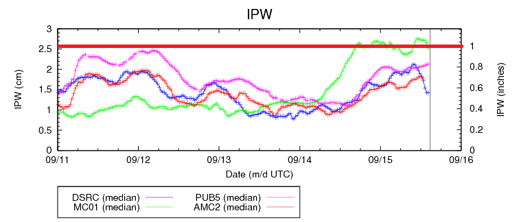
The scattered showers/weak thunderstorms over the High Country today/tonight will be garden-variety, thanks to unfavorable timing of the shortwave moving across the state, lessening moisture, and cloud cover limiting instability. The downward trend is already evident for Grand Junction (green line) in the IPW graph above. The best rainfall will occur over the Northwest Slope, Grand Valley, and western extents of the Northern Mountains regions; even so, maximum rain rates will be 0.4-0.7 inches/hour, which is below flash flooding thresholds. Most of the activity will be confined to the along and west of the Continental Divide and north of I-70 where moisture will hang on the longest.
The fire danger cannot be oversold today as dry fuels, gusty winds, and low relative humidities will combine to create significant fire conditions for the regions listed above. Red Flag Warnings have been issued by the National Weather Service, so be sure and check with your local NWS office for more details. Please, avoid any outdoor burning in locations under the Red Flag Warning, and be especially careful disposing of cigarettes.
Finally, there will be a couple of isolated strong-to-severe storms develop along the CO/KS border, thanks to a developing dry line and passing shortwave disturbance. The near-surface environment will be dry, so the main threats will be strong outflow winds, dry lightning, and perhaps a bit of hail. Very little rainfall will occur.
Today’s Flood Threat Map
For more information on today’s flood threat, see the map below (hover over threat areas for more details). For Zone-Specific forecasts, jump below the map.

Zone-Specific Forecasts
Northwest Slope, Northern Mountains, Front Range, Southeast Mountains, Central Mountains, San Luis Valley, Grand Valley, San Juan Mountains, and Southwest Slope:
Scattered showers/weak thunderstorms expected today through tonight as the upper-level longwave trough continues to advance across the western US. The best rainfall will occur across the Northwest Slope, Grand Valley, and western portions of the Northern Mountains where moisture will be best. No flash flooding is expected. Fire danger is high across portions of the Front Range and Central Mountains.
Rain rates will generally be light at less than 0.25 inches/hour. Any potential for rain rates greater than that will exist across the aforementioned regions, at 0.4-0.7 inches/hour.
Timing: 11 AM – 6 AM
Urban Corridor, Northeast Plains, Southeast Plains, Palmer Ridge, and Raton Ridge:
Red Flag Warnings are in place, and a couple of isolated strong-to-severe storms are possible near the CO/KS border. These thunderstorms will be capable of producing damaging outflow winds, dry cloud-to-ground lightning, and hail.
Across the Urban Corridor, an isolated shower/weak thunderstorm moving overhead cannot be ruled out, but will result in only gusty outflow winds and some lightning; no rainfall is expected.
Timing: 2 PM – 9 PM