Issue Date: Thursday, September 29th, 2022
Issue Time: 9:30AM MDT
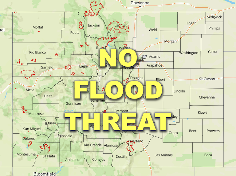
— Flooding is NOT expected today
— Fire-Burn Forecast Summary: 1 burn area under LOW threat; click HERE for more info
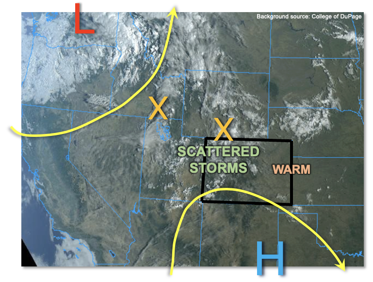
Today will be a transition day between the warm, relatively dry weather that Colorado has seen over the past few days, to a cooler, rainier weather pattern setting up beginning tomorrow. As shown in the visible satellite image, below, the upper-level ridge continues to weaken to our southeast. This has allowed for the import of moister air of monsoonal/Pacific origin into our state this morning. Grand Junction’s PW has risen notably from 0.63 to 0.76 inches. Further east, Platteville has also seen some modest moistening with a PW rising from 0.48 to 0.63 inches over the past 24 hours. PW will continue to very gradually rise through the day, and over the next 24-48 hours. However, the majority of this will be above the boundary layer, and thus not very impactful for thunderstorm potential. As also seen in the visible satellite image, a strong trough has entered the Pacific Northwest as of this morning. It will move ESE into the Northern Rockies over the next few days, but help push a couple of weak disturbances (“X” in image below) across mainly northern Colorado today. With the enhanced dynamics, we expect an increase in shower and storm activity for mainly western Colorado. Scattered showers and storms are expected by early afternoon, and persisting into the evening hours. Although brief moderate rainfall intensity is possible, flooding is NOT expected today. A couple of showers and weaker storms could also persist into the early overnight hours over the Northern Mountains.
Today’s Flood Threat Map
For more information on today’s flood threat, see the map below. If there is a threat, hover over the threat areas for more details, and click on burn areas to learn more about them. For Zone-Specific forecasts, scroll below the threat map.
Zone-Specific Forecasts:
Northern Mountains, Central Mountains, Grand Valley, San Juan Mountains, Southwest Slope, San Luis Valley, Northwest Slope, Front Range & Southeast Mountains:
Becoming mostly cloudy with scattered showers and storms developing by early afternoon. Max 30-min rain rates up to 0.5 inches are possible over far northern Colorado, and up to 0.4 inches elsewhere. Flooding is NOT expected today.
Primetime: Noon through 9PM, with isolated showers persisting into the early overnight hours
Northeast Plains, Southeast Plains, Urban Corridor, Palmer Ridge & Raton Ridge:
Mostly sunny and warm with high temperatures a few degrees above normal. Isolated showers and perhaps a weaker storm cannot be ruled out this afternoon and evening, especially closer to the foothills. Max 30-min rain rates up to 0.2 inches.
Primetime: 2PM through 7PM