Issue Date: Wednesday, September 21st, 2022
Issue Time: 10:10AM MDT
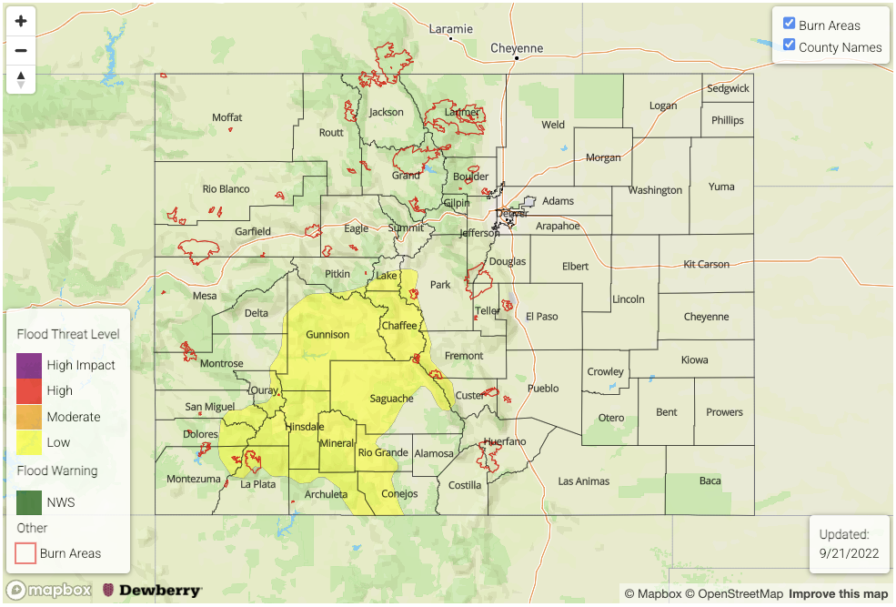
— A LOW flood threat has been posted for parts of the Central Mountains, Southeast Mountains, San Juan Mountains and Southwest Slope
— Fire-Burn Forecast Summary: 3 burn areas under MODERATE threat; 4 areas under LOW threat click HERE for more info
The well anticipated plume of late season monsoonal moisture begins its foray into Colorado beginning today, lasting through tomorrow. In addition, plenty of dynamical support provided by a cut-off low over northern California (see visible satellite image below) will keep rain in the forecast nearly statewide. PW at Grand Junction has increased from 0.73 to 0.92 inches over the past 24-hours. Moisture has also increased sharply over eastern Colorado with Platteville PW climbing from 0.43 to 0.93 inches! Moreover, moisture is well distributed through the entire atmosphere, including a very moist boundary layer especially by late September standards. In short, moisture will not be the limiting factor to the heavy rainfall threat.
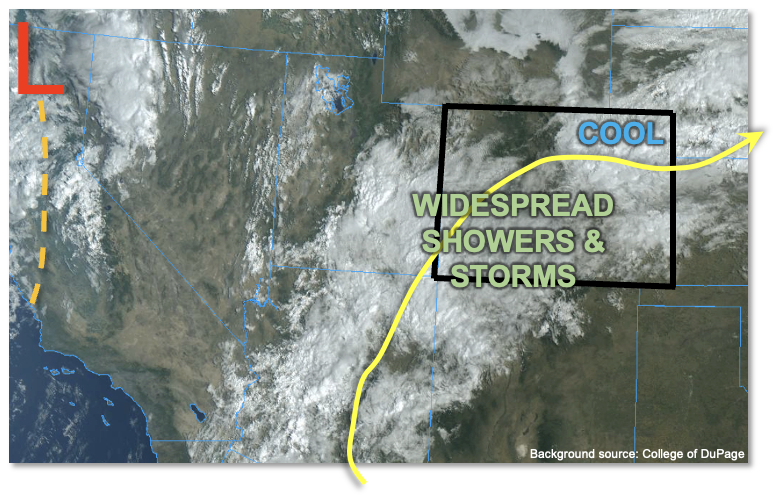
There are two limiting factors to the flood threat today: (increasingly) quick steering flow and limited instability. Steering flow this morning is already at 20+ mph and will continue to increase to 25-30 mph by afternoon. Regarding instability, as seen in the visible satellite image, below, an expansive, thick cloud deck will limit sunshine for most of central and western Colorado today. In turn, maximum instability will be a meager 500-700 J/kg CAPE, and only for a period of several hours. On a day like today, with a tropical-style “moist adiabatic” sounding, instability does not tell the entire heavy rainfall threat. Cloud warm layer depths of up to 1km will overcome limited instability to produce relatively efficient rainfall rates, but still constrained overall by quick steering flow.
To sum everything up, we expect a quick increase in shower and storm activity mainly over the central and southern higher terrain. Over primarily southern portions of the higher terrain, the combination of highest instability, warmest boundary layer and relatively slower steering flow (especially through mid-afternoon) warrants a LOW flood threat for primarily the 2-3 hour duration through this afternoon. A lull in activity is expected later this evening, ahead of another round of showers and weaker, embedded storms that are expected to accompany the approaching upper-level trough overnight.
Elsewhere, low to briefly moderate intensity rainfall is expected with significant total accumulation likely by Thursday afternoon, but flooding issues are not expected.
Today’s Flood Threat Map
For more information on today’s flood threat, see the map below. If there is a threat, hover over the threat areas for more details, and click on burn areas to learn more about them. For Zone-Specific forecasts, scroll below the threat map.
Zone-Specific Forecasts:
Central Mountains, Southeast Mountains, San Juan Mountains, San Luis Valley, Southwest Slope & Grand Valley:
Overcast with showers and storms increasing in coverage by late morning. Max 1-hour rain rates up to 0.9 inches with max 3-hour rain rates up to 1.8 inches. A LOW flood threat has been posted for southern and central parts of the higher terrain for this afternoon through early evening, where multiple rounds of moderate rainfall could trigger isolated flash flooding, debris slides and mud flows over steeper terrain.
Activity should subside temporarily by late evening, but another round of showers and storms is expected overnight. Max 1-hour rain rates up to 0.7 inches with this activity.
By Thursday morning, total rainfall up to 2.5 inches is expected over parts of the San Juan Mountains and Central Mountains.
Primetime: 1PM through 6AM Thursday (continuing into Thursday afternoon)
Northwest Slope, Northern Mountains, Front Range, Urban Corridor, Palmer Ridge & Northeast Plains:
Mostly cloudy and cool with scattered to widespread showers and weak storms expected this afternoon and evening. Max 30-min rain rate up to 0.5 inches possible, with max 3-hour rainfall up to 1.2 inches. Some ponding of rainfall may occur in low lying areas but flooding is NOT expected today.
Showers and embedded storms are expected to continue into the overnight hours, with max 1-hour rain rates up to 0.6 inches.
By Thursday morning, total rainfall up to 1.5 inches is expected over parts of the Front Range.
Primetime: 2PM through 6AM Thursday (continuing into Thursday afternoon)
Raton Ridge and Southeast Plains:
Mostly cloudy and much cooler today with widely scattered showers and storms developing this afternoon. Max 30-min rain rates up to 0.5 inches (west) and 0.8 inches (east, right along KS border) are possible, but flooding is NOT expected today.
Primetime: 2PM through 6AM Thursday