Issue Date: Thursday, September 15th, 2022
Issue Time: 10:25AM MDT
— A LOW flood threat has been posted for parts of the Palmer Ridge and Northeast Plains
— Fire-Burn Forecast Summary: 3 burn areas under LOW threat; click HERE for more info
One does not have to live in Colorado for a long time to know that morning clouds during the warm season are unusual. As seen in the visible satellite image, below, an expansive cloud deck resides over the western and central parts of the state. Ongoing showers and weak storm activity is noted over the Northern Mountains, Central Mountains and Northwest Slope. The supporting feature is a mid-level disturbance, of modest intensity, draped from northwest Colorado through the New Mexico border. This feature is well juxtaposed with a moisture maximum: this morning’s PW at Grand Junction continued to run high at 0.91 inches, while Platteville came in at 0.80 inches.
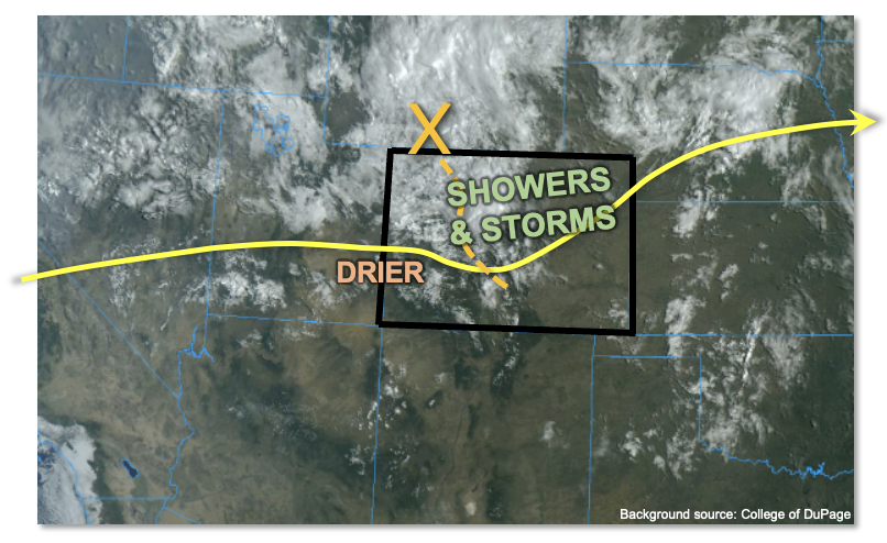
As the disturbance moves across the state, PW is expected to stay elevated over central and eastern Colorado, while falling slightly over far western areas. This will support scattered to widespread showers and storms today, mainly over the northeastern quadrant of the state. Most activity over the higher terrain will be benign, with only brief moderate to (very briefly) heavy rainfall expected. Instability will be a key uncertainty as the expansive cloud deck will limit heating in its vicinity. However, over parts of the Front Range, Palmer Ridge and Northeast Plains, instability up to 1,200 J/kg CAPE is expected to develop this afternoon. Additionally, with low-level flow backing to have a notable southerly component by early afternoon, a Denver Cyclonic Vorticity Zone is expected to develop. This will promote enhanced convergence over the climatologically favored Palmer Ridge area. In this region, 30-60 minutes of heavy rainfall will be possible during a 2-3 hour window this afternoon. A LOW flood threat has been posted for isolated flash flooding in this region. Storms are expected to weaken into showers by early evening as instability wanes. Nonetheless, very welcome rainfall is expected for parts of the Northeast Plains.
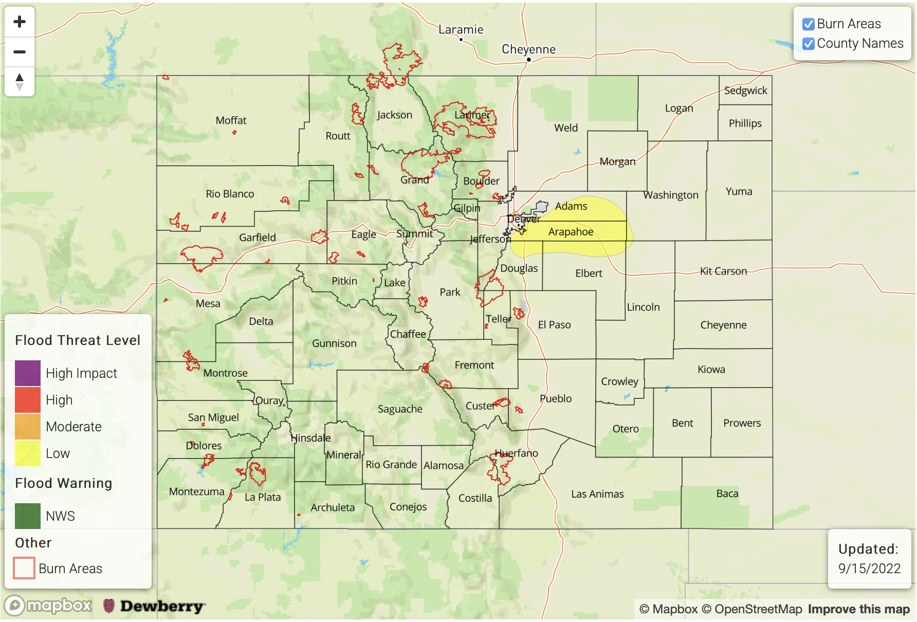
Today’s Flood Threat Map
For more information on today’s flood threat, see the map below. If there is a threat, hover over the threat areas for more details, and click on burn areas to learn more about them. For Zone-Specific forecasts, scroll below the threat map.
Zone-Specific Forecasts:
Northeast Plains, Urban Corridor & Palmer Ridge:
Increasing clouds with scattered to widespread showers and storms developing by early afternoon. Max 30-min/60-min rain rates up to 1.2/1.6 inches possible especially over parts of the northern Palmer Ridge. A LOW flood threat has been posted for this area.
Elsewhere, brief moderate to heavy rainfall is possible especially during the afternoon, with max 30-min accumulation up to 0.6 inches (west) and 1.0 inches (east). However, flooding is NOT expected.
Primetime: 1PM to 9PM
Northwest Slope, Northern Mountains, Central Mountains, Front Range & Grand Valley:
Mostly cloudy with scattered showers and embedded storms expected through mid-afternoon, then some clearing is possible. Cool conditions with temperature 5-10F below normal today. Max 30-min rain rates up to 0.5 inches possible. Some ponding of runoff may occur, but flooding is NOT expected today.
Primetime: 10AM through 5PM
San Juan Mountains, Southwest Slope, Southeast Plains, Southeast Mountains, Raton Ridge & San Luis Valley:
Mostly sunny early, then partly cloudy with isolated to widely scattered showers and weak storms possible. Max 30-hour rain rates up to 0.7 inches (far eastern areas towards KS border) and 0.4 inches (west of I-25). Flooding is NOT expected today.
Primetime (west): 10AM through 4PM
Primetime (east): 1PM through 9PM