Issue Date: Tuesday, September 13th, 2022
Issue Time: 9:15AM MDT
— A LOW flood threat has been issued for the San Juan Mountains, Grand Valley and portions of the Northwest Slope, Southwest Slope and Central Mountains
— Fire-Burn Forecast Summary: 3 burn areas under LOW threat; click HERE for more info
As we’ve been tracking in the FTO a major pattern change has begun as an incoming trough helps to push the remnants of Hurricane Kay over western Colorado today. The water vapor imagery below shows the nice subtropical moisture plume in blue, and widespread lift is accompanying the disturbance. As this feature moves northeast throughout the day and into tomorrow, there will be an increase in PW and mid and upper-level dynamics over the area. Today, these features are expected to cause widespread rainfall over western Colorado. The current cloud cover over the area is forecast to expand in coverage with showers already beginning over the southwest corner of the state.
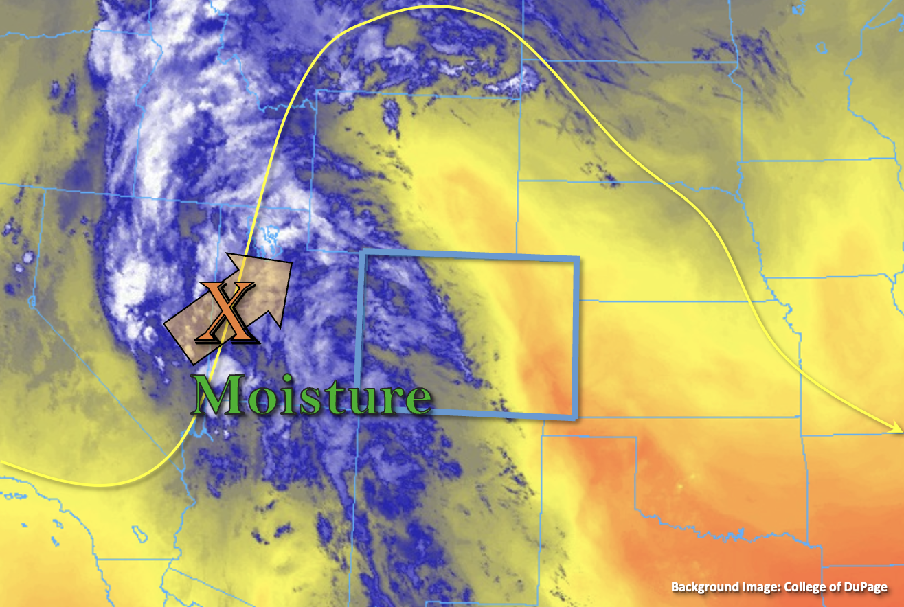
PW at Grand Junction has risen quite a bit over the last 24-hours and was measured at 0.75 inches this morning. However, a dry surface layer was noted in the sounding. As the multi-hour rainfall event begins, the dew point depression should begin to lessen, which means rainfall rates should become more efficient with higher accumulations possible over the lower elevation valleys. While fairly quick southeast to northwest storm motion should somewhat limit the threat from any individual storm, training storms are expected to increase the flood threat over portions of the high terrain. This is especially true for south and southwest facing slopes. Due to the longer duration threat from rainfall today, a LOW flood threat has been issued.
Meanwhile, it should remain dry for most of eastern Colorado with PW at Platteville measured at a measly 0.27 inches. A couple isolated showers may develop along and near the Continental Divide, over the Southeast Mountains and adjacent Raton Ridge area, but accumulations are expected to remain light.
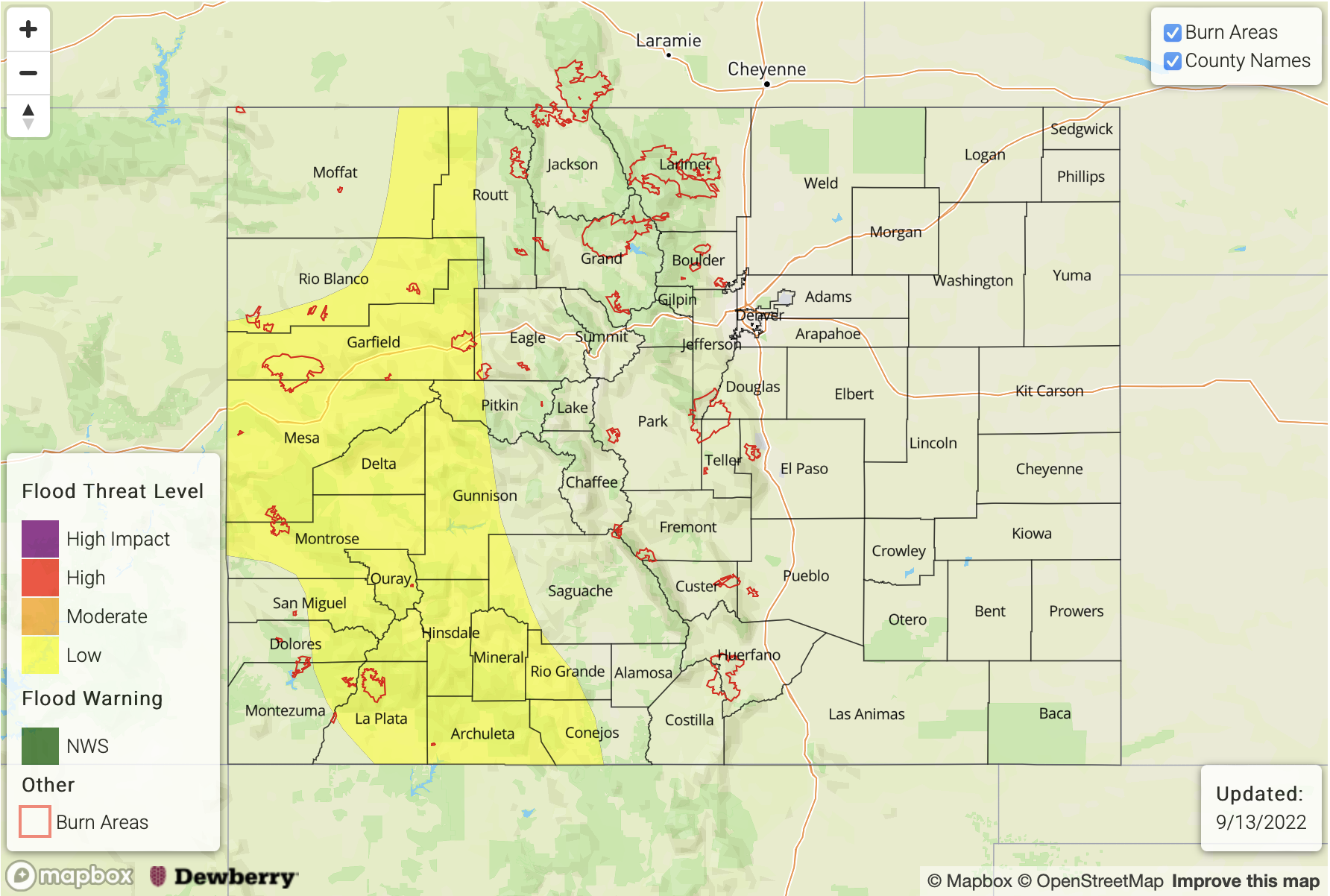
Today’s Flood Threat Map
For more information on today’s flood threat, see the map below. If there is a threat, hover over the threat areas for more details, and click on burn areas to learn more about them. For Zone-Specific forecasts, scroll below the threat map.
Zone-Specific Forecasts:
Northern Mountains, Central Mountains, Northwest Slope, Grand Valley, San Luis Valley, San Juan Mountains & Southwest Slope:
Max 30-minute rain rates up to 0.9 inches and 3-hour rain rates up to 1.9 inches will be possible for these zones today. Best chances for the higher accumulations will be over the south and southwest facing slopes of the high terrain where training storms are most likely to develop. Due to the isolated nature of the heavier rainfall totals, only a LOW flood threat has been issued. Flood threats today include mud flows and debris slides over steeper terrain along with ponding in low-lying areas. Rises on local streams and creeks may also be possible closer to the heavy rainfall cores. Most rainfall should come to an end by later this evening, but lighter rainfall is likely to linger over the high terrain into tomorrow morning.
Primetime: 10AM to Ongoing
Southeast Mountains, Front Range, Raton Ridge, Urban Corridor, Palmer Ridge, Northeast Plains & Southeast Plains:
Not much rainfall action today. Best chance for isolated storms will be over the Southeast Mountains with storms also possible over the Front Range along and near the Continental Divide late today into tonight. Isolated afternoon storms could also develop over the Raton Ridge area with moisture from the south sneaking northwards. If storms can develop north of the southern border, totals should remain under 0.25 inches. With only light storm totals forecast, flooding is NOT expected. Otherwise, another dry day is forecast with temperatures remaining above average.