Issue Date: Wednesday, September 7th, 2022
Issue Time: 10:50 AM MDT
Summary:
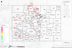
The upper-level ridge continued its dominance across our region on Tuesday, with more record-breaking warmth and dry conditions. The exception was again across the southern San Juans, where isolated storms impacted the highest elevations. QPE data suggests amounts up to 0.50” in the vicinity of Durango, where an automated station measured 0.40”. The QPE maximum in extreme southwestern Kit Carson County was not precipitation but rather the radar picking up on a wind farm.
The high temperature at Grand Junction Airport hit 101 degrees yesterday, breaking the previous record of 99. Check out some of the other records that were broken yesterday:
Record breaking highs for Tuesday. Thanks to our cooperative observers for the great info they provide for us! #cowx pic.twitter.com/PQvmk4F4PZ
— NWS Boulder (@NWSBoulder) September 7, 2022
No flooding was reported yesterday. For precipitation estimates in our area, check out the map below. Remember, if you observe flooding in your area, you can use the “Report a Flood” page to make a flood report when you can safely do so.
