Issue Date: Sunday, August 28th, 2022
Issue Time: 10:35 AM MDT
Summary:
Saturday was a much less eventful day across Colorado in terms of precipitation. Residual moisture from the day prior and the beginning of fall-like temperatures in Northern Colorado caused many to wake up to cooler, foggy conditions which dampened storm development in the morning. Dry air mixing into the midlevels of the atmosphere from the west also helped to limit storms throughout the day. Still, some isolated convection was able to pop up along the high terrain in Western Colorado thanks to diurnal heating. Eastward storm progression eventually allowed some widely scattered storms along the Front Range and Urban Corridor as well, though with very modest precipitation totals. By nightfall, any lingering storms quickly dissipated without daytime heating.
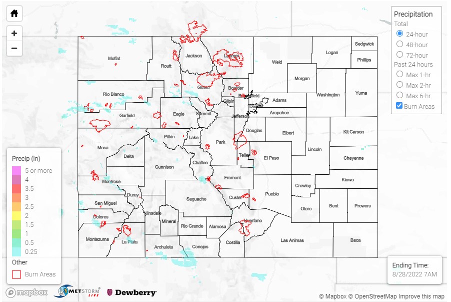
Highest precipitation totals were observed in the Southwest Slope and San Juan Mountains yesterday. A trained spotter reported pea to dime sized hail, as well as 0.36 inches of rainfall near Vallecito in the Southwest Slope. Across La Plata county, 0.30-0.67 inches was reported by CoCoRaHS observers, including 0.47 in Durango.
On the Northwest Slope, a flash flood warning was issued for Rio Blanco and Garfield counties, including the 2019 Hunt fire. Observations in this part of the state are particularly limited and QPE does not place any precipitation over that burn scar itself. Still, MetStormLive placed between 0.25-0.50 also from a line of convection that developed along a boundary near the Rio Blanco and Garfield county borders. In the Central Mountains, a flash flood warning was issued for Gunnison and Pitkin counties. There a CoCoRaHS observer in Redstone reported 0.19 inches, though QPE placed between 0.25-0.50 from a nearby isolated convective cell. A bit further east, another flood advisory was issued for Larimer County, including portion of the Cameron Peak burn scar. The Northern Mountains and Front Range saw some widely scattered afternoon showers and thunderstorms, though rainfall totals were limited.
No flooding was reported on Saturday. For precipitation estimates in your area, check out the map below. Remember, if you observe flooding in your area you can use the “Report a Flood” page to make a flood report, when it’s safe to do so.
Denver’s radar is down for maintenance upgrades through the end of August. QPE may be underestimated across the region.
Click Here For Map Overview