Issue Date: Sunday, August 28th, 2022
Issue Time: 10:35 AM MDT
— Flooding is NOT expected today
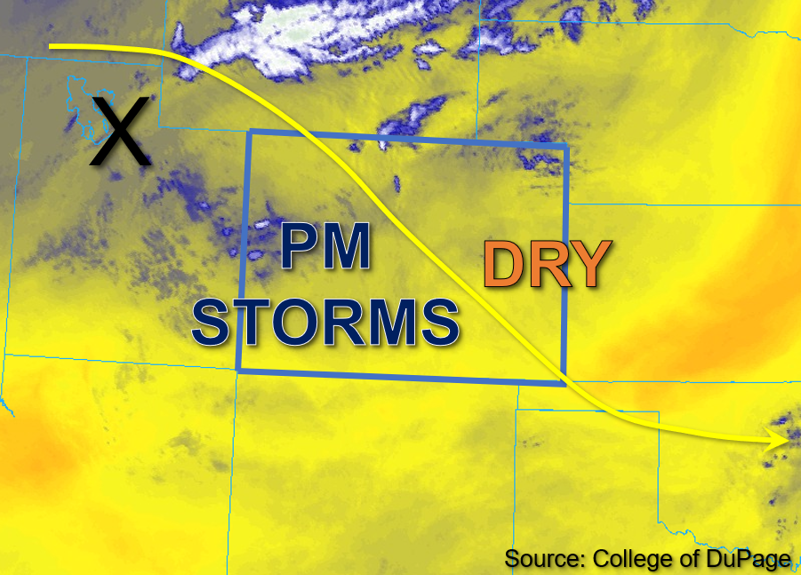
A weak disturbance currently located in the central part of Colorado is expected to exit the state today, followed by another disturbance moving in from the west from Utah, which is marked by the “X” in the water vapor image below. These mid-level dynamics are expected to trigger isolated to widely scattered storms across the western half of the state today. The most notable change in the forecast today from prior days, and the greatest hindrance to storms, is the sharp decrease in moisture throughout Colorado.
Grand Junction measured PW was 0.80 inches, a slight moistening from yesterday, while Platteville measured a significant drop in column moisture with a PW of 0.46 inches; this indicates a very sharp moisture gradient from west to east across the state. Additionally, surface dewpoints in the upper 30s to low 40s°F indicate boundary layer moisture has also dropped significantly from yesterday over eastern Colorado. Given negligible instability over eastern Colorado, most storms should be confined to the mountains west of the Continental Divide this afternoon. However, with weak forcing from the aforementioned disturbance, some elevated showers and weak storms may drift into the eastern plains this afternoon and produce primarily gusty winds with only limited rainfall accumulation.
Further west, both column and boundary layer moisture are slightly higher with surface dew points averaging in the mid-40s°F. Instability values are forecast to reach between 500-1000 J/kg of CAPE this afternoon across parts of western Colorado. Combined with the added energy from the incoming mid-level dynamics, this will provide enough added lift to trigger widely scattered storms over primarily higher elevations of western Colorado this afternoon. The combination of greatest depth of moisture and instability is forecast to be over the central and southern San Juan Mountains and is thus where the isolated heaviest downpours will be possible with the stronger storms this afternoon. Still, rain rates are expected to remain below flood thresholds and flooding is NOT expected today.
Today’s Flood Threat Map
For more information on today’s flood threat, see the map below. If there is a threat, hover over the threat areas for more details, and click on burn areas to learn more about them. For Zone-Specific forecasts, scroll below the threat map.

Zone-Specific Forecasts:
Southwest Slope, San Juan Mountains, San Luis Valley, Grand Valley, Central Mountains, Northern Mountains, & Northwest Slope:
Some scattered clouds and a few isolated weak rain showers are ongoing across portions of western Colorado this morning. By early afternoon, isolated to widely scattered storm development is likely along and west of the Continental Divide. This rainfall is expected to be mostly light to moderate in intensity except over portions of the higher elevations of the Central Mountains, San Juan Mountains, and eastern Southwest Slope. Isolated max 30-to-45-minute rain rates up to 0.4 inches will be possible for the Northern Mountains and Northwest Slope, and up to 0.6 inches will be possible for the Central Mountains, Southwest Slope, and San Juan Mountains. Gusty winds, lightning, minor field ponding, and light runoff over steep terrain may occur, but NO flooding is expected today.
Primetime: 1PM to 9PM
Front Range, Urban Corridor, Northeast Plains, Palmer Ridge, Southeast Plains, Southeast Mountains, & Raton Ridge:
Skies are mostly clear this morning for eastern Colorado aside from a few stray high clouds. By early to mid-afternoon, a few isolated to widely scattered rain showers or weak storms are expected to develop over the Front Range and Southeast Mountains and drift into the adjacent foothills. Max 30-to-45-minute rain rates up to 0.4 inches will be possible for the southern Urban Corridor and Palmer Ridge, and up to 0.6 inches for the southern Front Range and the northern Southeast Mountains. These storms should be quicker moving relative to the western half of the state due to faster steering speeds east, and given weak instability and limited moisture, they should be short-lived. Therefore, NO flooding is expected today.
Primetime: 2PM to 11PM