Issue Date: Saturday, August 27th, 2022
Issue Time: 10:25 AM MDT
— Flooding is NOT expected today
— Fire-Burn Forecast Summary: 3 burn areas under LOW threat, click HERE for more info
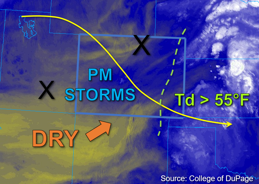
This morning, midlevel dynamics associated with the upper trough continue to move out of eastern Colorado, with drier air and subsidence pulling in behind it. Meanwhile, a weak disturbance in the flow is forecast to move into western Colorado with some subtle midlevel dynamics this afternoon, as noted by the furthest west “X” in the water vapor image below. Moisture throughout the column and boundary layer has dropped notably since yesterday for central and western Colorado, with Grand Junction measuring a PW value of 0.78 inches this morning, and Platteville measure a PW value of 0.75 inches. At the surface, dewpoints in the mid-40s°F are common over western Colorado except for some low-50s°F noted over the far southwest portions of the state near the New Mexico border. Dewpoint depressions are small for much of western Colorado and resulted in valley fog this morning across some lower elevations that is beginning to erode.
As the weak midlevel impulse enters western Colorado this afternoon, it will combine with the diurnal upslope circulation to trigger isolated storms over some of the higher elevations west of the Continental Divide. With surface moisture forecast to mix out significantly today, these storms should produce primarily gusty winds north and west of the Continental Divide, with the heavier rainfall chances focused over the southwest portions of the state where more residual surface moisture should remain. Additionally, instability values between 800-1200 J/kg of CAPE are forecast for these areas. Given steering speeds forecast in the 5 to 10mph range, these storms could potentially anchor to the high terrain and produce relatively brief, but locally heavy rainfall within a few hours window before instability drops and drying increases. However, rain rates are expected to remain just below flood thresholds so NO flooding is expected today.
Over far eastern Colorado, dew points in the mid and upper 50s°F and even low 60s°F were noted with PW above 1 inch. Though some continued drying is expected statewide, some areas in the far southeastern plains may be able to hold onto some surface moisture. An isolated storm or two may drift across this area and produce brief, locally moderate to heavy rainfall due to higher instability values forecast to reach between 1200-1800 J/kg of CAPE. However, forcing for storms in this area should be weak and thus preclude a greater rainfall threat. NO flooding is expected today.
Today’s Flood Threat Map
For more information on today’s flood threat, see the map below. If there is a threat, hover over the threat areas for more details, and click on burn areas to learn more about them. For Zone-Specific forecasts, scroll below the threat map.

Zone-Specific Forecasts:
Southwest Slope, San Juan Mountains, San Luis Valley, Grand Valley, Central Mountains, Northern Mountains, & Northwest Slope:
Early morning valley fog across some lower elevations is eroding, leading to mainly clear skies for the western half of the state. This afternoon, isolated to widely scattered storms are expected to develop over primarily the higher terrain west of the Continental Divide. These storms will be capable of producing 30-to-45-minute rain rates of up to 0.8 inches, along with lightning and gusty winds for mainly the Southwest Slope, western San Juan Mountains, and the Grand Valley. Further north, isolated storms are also possible over the Northwest Slope and Northern Mountains, but given the forecast dry boundary layer, 30-to-45-minute rain rates up to 0.5 inches are anticipated. Aside from isolated light runoff over the steeper terrain and perhaps some minor road and field ponding at lower elevations under the isolated stronger storm cores, NO flooding is expected today.
Primetime: 1PM to 9PM
Front Range, Urban Corridor, Northeast Plains, Palmer Ridge, Southeast Plains, Southeast Mountains, & Raton Ridge:
Clear skies and temperatures slightly cooler than yesterday are expected for eastern Colorado today. With some surface moisture forecast to remain in place over the far Southeast Plains, a few isolated storms may be possible over the southeastern border counties. Forcing is lacking, but given the forecast moderate instability and a fairly deep layer of southerly flow, a storm or two may be able to stall out and produce 30-to-45-minute rain rates up to 0.8 inches, along with gusty winds and perhaps some small hail. A few stray weak showers may also be possible over the Front Range and Southeast Mountains, as well as over the far Northeast Plains, but moisture and instability are much more lacking in these areas. NO flooding is expected today.
Primetime: 2PM to 8PM