Issue Date: Tuesday, August 23rd, 2022
Issue Time: 10:35 AM MDT
— Flooding is NOT expected today
— Fire-Burn Forecast Summary: 3 burn areas under LOW threat; click HERE for more info
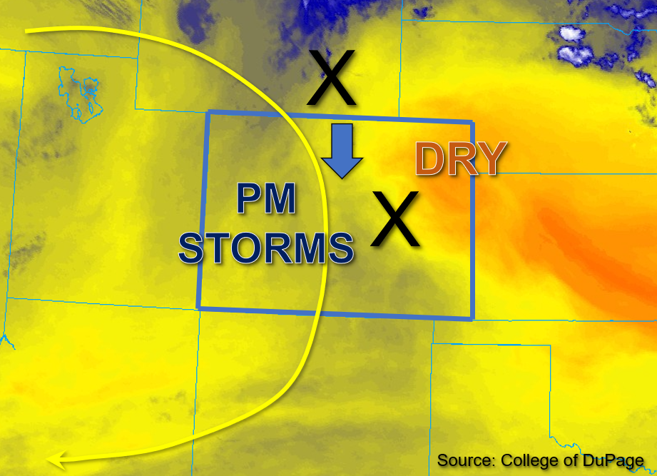
As the high pressure to the west continues to build, associated subsidence is pushing into Colorado from the north. A disturbance in the flow is currently located in central Colorado, and a secondary disturbance is located further north over Wyoming (both marked by the “X’s” in the water vapor image below); both of which are forecast to move southward throughout the state with the northerly flow today. These weak impulses should provide some subtle midlevel energy to trigger widely scattered storms in the higher elevations mainly along and west of the Continental Divide this afternoon.
Column moisture is continuing to trend downward from prior days, with Grand Junction measuring a PW value of 0.8 inches and Platteville measuring PW of 0.66 inches this morning, both notably decreased from yesterday. Additionally, surface dewpoints in the upper 30s to mid-40s°F (northwest) and upper 40s to low 50s°F (south and east) show a decrease in boundary layer moisture as well. What moisture remains this morning is forecast to mix out beginning early afternoon with the dry air intrusion moving in from the north. While a few isolated to widely scattered storms may develop over the mountains, the northern storms are expected to produce mainly gusty winds, along with a brief shower or two with low rain rates given low forecast instability and meager moisture.
Meanwhile across the southwestern portions of the state, instability may reach values between 800-1200 J/kg of CAPE this afternoon. With slightly greater boundary layer moisture forecast over these areas and enhanced uplift from terrain, initially convective storms may produce locally heavy downpours. But given the decreasing moisture throughout the day, the window for heavy rainfall should be limited to only 30 to 45 minutes before storms weaken in intensity. Therefore, NO flooding is expected today.
Today’s Flood Threat Map
For more information on today’s flood threat, see the map below. If there is a threat, hover over the threat areas for more details, and click on burn areas to learn more about them. For Zone-Specific forecasts, scroll below the threat map.

Zone-Specific Forecasts:
Southwest Slope, San Juan Mountains, San Luis Valley, Southeast Mountains, Grand Valley, Central Mountains, Northwest Slope, & Northern Mountains:
As patchy early morning fog in parts of central and southwest Colorado continues to erode this morning, some high mountain clouds are beginning to build. By early afternoon, widely scattered storm development is anticipated over the high terrain along and west of the Continental Divide. Echoing the pattern of prior days, these storm cores should remain small. The greatest heavy rainfall chances exist over portions of southwestern Colorado where isolated 30-minute rain rates up to 0.6 inches and 45-minute rain rates up to 0.8 inches are possible, specifically over the western San Juan Mountains and eastern Southwest Slope. Some runoff may occur over steeper terrain but NO flooding is expected today.
Primetime: 1PM to 10PM
Front Range, Urban Corridor, Northeast Plains, Palmer Ridge, Southeast Plains & Raton Ridge:
Skies are mostly clear this morning across eastern Colorado. This afternoon, an isolated to a few widely scattered storms may develop over the mountains, with an additional storm or two possible over the Palmer and Raton Ridges. Given the forecast meager moisture and instability, these storms should produce primarily gusty winds, with max 30-minute rain rates up to 0.4 inches and 45-minute rain rates up to 0.6 inches possible over the mountains and ridges. NO flooding is expected today.
Primetime: 3PM to 9PM