Issue Date: 9/8/2015
Issue Time: 8:57 AM
NO FLOOD THREAT IS FORECAST.
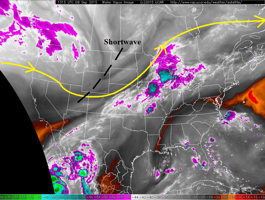
If you love September weather in Colorado, chances are good that you will love today’s forecast. Drier, subsident air will work in from the west behind a shortwave translating across the northern Rockies (black dashed line); this drier air will be responsible for the increase in sunshine and fewer showers/thunderstorms. As is typical with Colorado, however, there will be an opportunity for isolated-to-widely scattered showers/weak thunderstorms this afternoon and evening across the southern half of the state. Aside from that activity, though, today will overwhelmingly be marked by seasonable temperatures under partly-to-mostly sunny skies.
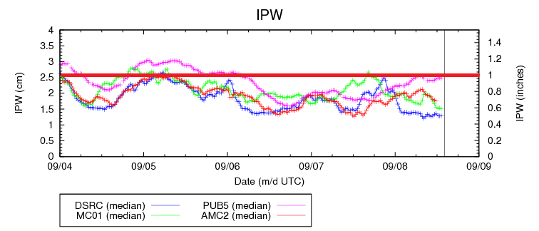
There are not any flash flooding concerns for today, as moisture is in fairly short supply. Pueblo has not received the effects of drying from the west just yet, but the IPW graph shows that the other three normal reporting stations (Grand Junction, Boulder, and Shriever AFB) have come under the drying influence. It is only a matter of time before Pueblo receives the same treatment. For more information regarding rain rates and timing, please check out the zone-specific discussions below.
Today’s Flood Threat Map
For more information on today’s flood threat, see the map below (hover over threat areas for more details). For Zone-Specific forecasts, jump below the map.

Zone-Specific Forecasts
Northwest Slope, Northern Mountains, and Grand Valley:
Mostly sunny skies and seasonable temperatures will be the weather story today. Overnight, mostly clear skies will give way to cooler than average low temperatures for tomorrow morning.
Front Range, Southeast Mountains, Central Mountains, San Luis Valley, San Juan Mountains, and Southwest Slope:
North of I-70, partly-to-mostly sunny skies will be present, allowing temperatures to climb to seasonal averages across the area. To the south of I-70, isolated-to-widely scattered showers/weak thunderstorms will develop this afternoon and evening, coming to an end around, or just after, sunset. Rain rates will not be very high, maximizing at 0.2-0.4 inches/hour, with most rates less than 0.2 inches/hour.
Timing: Noon – 8 PM, with a lingering shower or two over the Southeast Mountains until midnight.
Urban Corridor, Northeast Plains, Southeast Plains, Palmer Ridge, and Raton Ridge:
North of I-70, mostly sunny skies will prevail as the moisture/support sags further southeast as the day progresses. South of I-70, isolated-to-scattered showers/weak thunderstorms are expected this afternoon and evening, mainly across the Palmer Ridge, southern Urban Corridor, and western portions of the Southeast Plains/Raton Ridge. Further east, instability will be a bit higher so isolated thunderstorms cannot be ruled out, but chances are much lower than the aforementioned favored regions. Maximum rain rates are as follows:
Urban Corridor and Northeast Plains: 0.15-0.25 inches/hour
Palmer Ridge: 0.4-0.8 inches/hour
Southeast Plains and Raton Ridge: 0.8-1.2 inches/hour