Issue Date: Wednesday, August 17th, 2022
Issue Time: 10:25 MDT
Summary:
It was another active day for heavy rain across Colorado yesterday, and the Denver Metro Area/Urban Corridor saw an early start! By 9 AM, Broomfield had already received 3.5” of rainfall from a nearly stationary thunderstorm that lasted several hours.
In total, 3.70” was recorded in Broomfield in just 3 hours, which is 25% of the average annual rainfall! Throughout the afternoon, other areas of the city continued to see significant rainfall as well- up to 1.51” in Aurora. Two flood advisories were issued north of Denver, with many reports of streets, parks, and rivers with severe flooding specifically near Broomfield, Thornton, and Louisville. Some of the flooding events observed include:
• Rock Creek in Lafayette was completely submerged, with a report of at least 5 feet of water over the bike path
• 6” of water over Highway 287 in Broomfield
• Spader Way in Boulder was closed between 1st Ave. and DesCombes Drive due to flooding
• Continued flooding of Toll Gate Creek in Aurora
• Midway Park in Broomfield was severely flooded
Check out some of the flooding at a park in Broomfield, Colorado this morning.
The #Denver suburb received 3.70 inches of rain in just 3 hours today. For perspective, that’s 25% of their annual rainfall! #COwx pic.twitter.com/kFhE7u1ti9
— FOX Weather (@foxweather) August 16, 2022
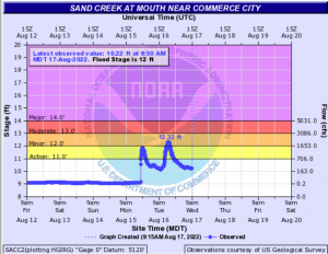
Only one stream reached flood stage yesterday, this time at Sand Creek near Commerce City. View the hydrograph below to see the significant increase in discharge from rainfall Monday and Tuesday, which ultimately pushed the creek into minor flood stage yesterday morning.
The Southeast Plains and south-central part of the state also saw heavy rainfall and increased activity yesterday from afternoon and evening storms. In the Southeast Plains, highest totals include 2.58” via a trained spotter in Walsh and 2.28” near Las Animas via a Mesowest gage. Most other observations ranged from 0.1”-2”. Moving west, totals over the Raton Ridge to San Luis Valley were generally between 0.15”-1.5”, including up to 1.4” near Trinidad, 1.49” southwest of Pueblo, and 1.24” near Huerfano, via CoCoRaHS observations and Mesowest gages. The Southwest Slope was a bit drier yesterday however, with observations staying mostly under 0.5”.
In the Grand Valley, the Pine Gulch burn scar was issued a flash flood warning, but it was cancelled by 6 PM with no flooding reported. This area saw up to 0.86” according to a CoCoRaHS observer, although other observations generally stayed between 0”-0.64”. To the south, a debris flow consisting of minor mudslides over Highway 145 in Telluride was reported yesterday as well, but the highway was quickly cleared within a few hours. Rainfall near Telluride was 0.23” or less.
The Central Mountains also saw continued rainfall from the day before, with totals for the area reaching up to 1.16” in Silverthorne, but generally staying between 0”-1”.
The northern Front Range and Urban Corridor stayed relatively dry, with trace -0.05” observations. Thankfully, there was no flooding yesterday on the Cameron Peak burn scar, although the Poudre River was observed to be dark brown from mud and sediment runoff from the rain in the area on Monday.
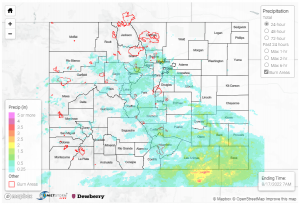
If you observe flooding in your area, remember to use the “Report a Flood” page to make any flood reports when you can safely do so. For precipitation estimates in our area, check out the map below.

