Issue Date: Tuesday, August 16th, 2022
Issue Time: 10:45 MDT
Summary:
Yesterday saw early morning showers for the Southeast Plains, associated with a frontal boundary extending back into eastern Colorado from a low centered over Nebraska/South Dakota. These showers cleared out from west to east by mid-morning from daytime heating along with the northeastward progression of the associated low. The Eastern Plains received between 0-1.0” in most places with a few higher totals such as 1.57” in Vernon and 1.2” near Lincoln.
Further west, late morning daytime heating combined with above normal precipitable water from a plume of monsoonal moisture circling the high-pressure ridge to the southeast, which allowed for convection to develop across much of the high terrain in the western half of the state. Storms increased in coverage and intensity as the afternoon progressed, and slow steering flow expanded storms onto the Urban Corridor and Palmer Ridge as well. Slow storm motion combined with ample available moisture allowed for very heavy rainfall, especially under embedded convection.
By evening, there was widespread coverage of showers and thunderstorms across much of the state. Drying generally occurred from west to east, as the high-pressure ridge weakened and moved eastward. Still, showers and thunderstorms lasted well into the overnight hours and early morning for the Southeast Plains, Palmer and Raton Ridge.
The Urban Corridor received the bulk of the rainfall yesterday- Flood Advisories and Severe Thunderstorm warnings patchworked the area from north Aurora and southeast Denver all the way to west of Colorado Springs. From Castle Rock up to northwest Aurora received the heaviest precipitation from the storms, with most observations in and around the city between 1-2”, although southwest and northeast of the city received lower amounts generally under 1”. Some of the most significant precipitation totals are listed below:
• 2.91” in Louviers
• 2.91” in Aurora
• 2.83” west of Castle Rock
• 2.76” in Broomfield
• 2.60” near Cherry Creek State Park
• 2.48” southwest of Lone Tree
Flooding was significant due to the amount of rainfall that occurred. Below are reports of street flooding in Southeast Denver and nearby areas:
• South Chambers Road in Aurora was impassable due to flooding
• South Parker Road in Aurora was impassable
• 6 inches of water at Mansfield and E Loyola Drive in Foxfield
• 6-12 inches of water at East Bellevue Avenue and Syracuse in Greenwood Village
• Approximately 1 foot of water at the I-25 northbound on-ramp in Centennial- see below!
• Several feet of water flooding a basketball court in Lone Tree
• Several feet of water flooding a gas station lot in Aurora
This was flash flooding at I-25 and Arapahoe Rd (CO 88) around 3:30pm today. @NWSBoulder #cowx #flooding pic.twitter.com/d4Y64lIeqK
— Kyle Witter (@kyle_witter) August 16, 2022
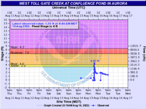
Several stream gages in the eastern metro area of Denver saw significant increases in discharge, some even reaching minor flood stage during the peak of the storm. The hydrograph below is from a stream gage in southeast Aurora. You can observe the spike in streamflow, reaching minor flood stage (over 4 feet) for a brief period of time.
North of Colorado Springs, flooding was reported in Elbert County over CR 106, between CR 5 and 13. However, northwest of the city saw the most activity- overlapping flood advisories, a severe thunderstorm warning, and multiple reports of 1” hail. In that area, flash flooding was reported 3 miles west of Callaghan, with “1-2 inches falling in the past hour”. Flash flooding was also reported in Peyton, along with up to 1.7” of rainfall.
Found some hail north of Peyton. #cowx pic.twitter.com/M1eU1uL25p
— Matt Minnillo and Blue Thunder (@MattBlueThunder) August 15, 2022
Out in the Grand Valley, there were many Flood Advisories issued, including partial coverage of the Pine Gulch burn scar. However, this area saw relatively low totals compared to surrounding areas to the south and east; only up to 0.25” in Grand Junction. The Southwest Slope received higher amounts, including up to 0.89” in Montezuma (this CoCoRaHS observer stated “I’m not sure that I’ve ever had so much rain in my 16 or more years of measuring.”), 0.91” northeast of La Plata, while the Raton Ridge area saw up to 1.02” in Trinidad! Other observations in the southwest range from 0”-0.8”.
The Central Mountains and Front Range received up to 1.20” of rainfall, concentrated around the areas west of Colorado Springs and Denver. South of Glenwood Springs saw at least 0.82”, and I-70 was closed yesterday by 7:00 PM due to a Flash Flood Warning issued over the Grizzly Creek burn scar, but reopened a few hours later. No flooding or debris flows have been reported.
Higher totals of up to 1.6” were observed near Drake and Estes Park, near the southern edge of the Cameron Peak burn scar. Four flood advisories over the burn area between approximately 2:13 PM and 7:15 PM. At 2:30 PM, reports came in from Larimer County Office of Emergency Management of flooding on the burn scar, resulting in an extended closure of several roads in the Retreat neighborhood. By 2:39 PM, emergency management had closed the road due to rockslides about 2 miles east of Drake.
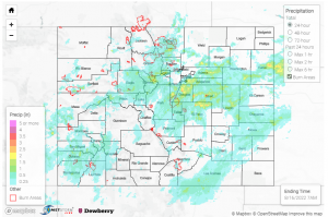
If you observe flooding in your area, remember to use the “Report a Flood” page to make any flood reports when you can safely do so. For precipitation estimates in our area, check out the map below.

