Issue Date: Tuesday, August 16th, 2022
Issue Time: 10:35 AM MDT
— The flood threat will persist into the overnight hours
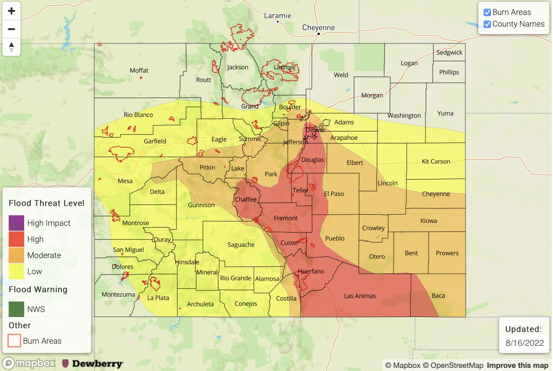
— A HIGH flood threat has been issued for the Southeast Mountains, Raton Ridge, Urban Corridor, Palmer Ridge, & Southeast Plains
— A MODERATE flood threat has been issued for the Grand Valley, Central Mountains, & Front Range
— A LOW flood threat has been issued for the San Juan Mountains, San Luis Valley, Southwest Slope, Northwest Slope, Northern Mountains, & Northeast Plains
— Fire-Burn Forecast Summary: 4 burn areas under HIGH threat, 4 burn areas under MODERATE threat, 1 burn area under LOW threat; click HERE for more info
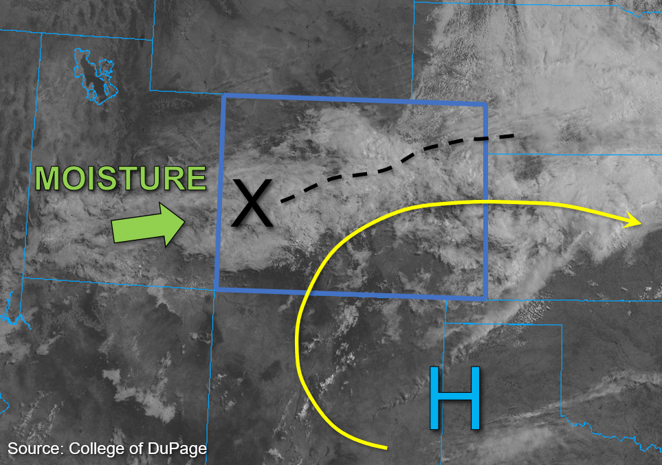
Rain showers are ongoing across portions of central and eastern Colorado with nearly 2 inches of rain in one hour already recorded near Broomfield this morning, and flooding is already occurring according to local storm reports. Midlevel energy continues to build across the state, marked by the “X” in the water vapor image below, and similarly to yesterday, monsoonal moisture continues to wrap around the high pressure (currently centered over the Texas panhandle). PW values of 1.20 and 1.34 inches were measured in Grand Junction and Platteville, respectively, indicating ample column moisture. At the surface, dew points in the low to mid-50s°F (west) and greater than 60°F (east) further shows the depth of moisture present even in the lowest levels of the boundary layer.
This afternoon, upslope flow in association with a deepening surface low pressure is expected to transport additional moisture in from the south and east, creating a pooling effect east of the Continental Divide where moisture can build up against the mountains and adjacent foothills. Instability is forecast to reach values of 1200-1800 J/kg of CAPE for portions of the Eastern Plains, with values ranging from 800-1100 J/kg of CAPE more common over the mountains and west of the Continental Divide. Initially, convective storms producing high rain rates are expected before instability wanes and storms transition to more widespread coverage. Thereafter, storms are expected to produce longer-duration moderate to heavy rainfall across most of southern and central Colorado over a 3-to-6-hour period. Given that west to southwesterly upper-level steering flow is forecast to be weak today, within the range of 5 to 10 mph (west) and 15 to 20mph (east), storms are expected to be relatively slow-moving. Of additional concern are soils that are already saturated from prior days of heavy rainfall; as such, all the aforementioned factors increase confidence in a higher-end flood threat for central and southern Colorado today.
A HIGH flood threat has been issued for portions of southeast Colorado, a MODERATE flood threat for portions of southern and central Colorado, and a LOW flood threat for portions of western and northern Colorado. Urban and small stream flooding are of particular concerns today, similarly to yesterday, with added concerns for excessive runoff, mud flows, and debris slides over steeper terrains that may receive several hours of moderate to heavy rainfall.
Today’s Flood Threat Map
For more information on today’s flood threat, see the map below. If there is a threat, hover over the threat areas for more details, and click on burn areas to learn more about them. For Zone-Specific forecasts, scroll below the threat map.
Zone-Specific Forecasts:
Southeast Mountains, Central Mountains, Grand Valley, Front Range, Urban Corridor, Palmer Ridge, Northeast Plains, Raton Ridge, & Southeast Plains:
Heavy rainfall is already occurring this morning over portions of the Front Range and Urban Corridor where 1-hour rain rates up to 2 inches have been recorded by local rain gages; this, along with several local storm reports of flooded roads in the area, has prompted the issuance of a Flash Flood Warning for portions of Boulder and Broomfield Counties by NWS Boulder until 11AM. Please refer to the local NWS for further information and warning issuance updates.
As storm coverage increases today, initially convective storms could produce 1-hour rain rates up to 2.25 inches and 3-to-6-hour storm totals of up to 6 inches for portions of the Southeast Mountains, Central Mountains, Front Range, Urban Corridor, Raton Ridge, and western Southeast Plains, warranting the issuance of a HIGH flood threat for these forecast zones. A MODERATE flood threat extends further east into the adjacent plains, further west toward Grand Valley, and further north, where max 1-hour rain rates of 1.75 inches and 3-to-6-hour storm totals up to 4 inches are possible. Urban and small stream flooding are of particular concerns today, along with excessive runoff, mud flows, and debris slides over steep terrain.
Primetime: Ongoing through Overnight
Southwest Slope, San Juan Mountains, San Luis Valley, Northwest Slope, & Northern Mountains:
Cloud cover overspreads much of western Colorado today, with some light embedded precipitation occurring over some of the higher elevations. Storm coverage should be more limited for these forecast zones today given lesser instability forecast for these zones. That said, storms may be briefly convective initially and produce max 1-hour rain rates up to 1.25 inches, and 3-hour storm totals up to 2.5 inches. Some minor urban and small stream flooding may occur, along with the potential for excessive run off, mud flows, and debris slides over steeper terrain; as such, a LOW flood threat has been issued for portions of the Southwest Slope, San Juan Mountains, San Luis Valley, Northwest Slope, and Northern Mountains.
Primetime: Ongoing through Overnight