Issue Date: Monday, August 15th, 2022
Issue Time: 11:40 AM MDT
Summary:
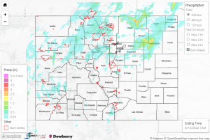
The upper-level ridge to our southeast weakened some on Sunday, allowing increased monsoonal moisture across the state and wider coverage of precipitation. Storms developed over the mountains by mid-afternoon, with some cells able to track into the lower elevations of the Northeast Plains later in the day. Rain generally fell along and north of I-70; QPE data suggests the heaviest rain fell across Weld, Morgan, and Washington Counties, with localized amounts up to 3”.
West of Denver, two Flash Flood Warnings were issued along I-70, including one for the Grizzly Creek burn scar, although flooding on the scar itself could not be confirmed. The Colorado Department of Transportation temporarily closed portions of I-70 as a precaution, while flash flooding was observed in Glenwood Springs off of Transfer Trail Road, per video posted to Twitter:
Flash flooding captured in Glenwood Springs, CO off of Transfer Trail Rd after some big storms rolled in. Flash flooding warning still in effect for the Glenwood Canyon.@9NEWS @DenverChannel @WeatherBug @weatherchannel @wunderground @NWSGJT #cowx #Weather #glenwoodsprings pic.twitter.com/Xx95P4h19P
— Watts Brooks (@WattsBrooks1) August 15, 2022
Rainfall amounts of 2.04” and 1.04” were measured near Glenwood Springs. Additionally, a rockslide was reported along CO-131 at Old Bond Road, and a mudslide was reported along US-24 between Eagle River and FS Road 762. Several other flood reports were received by CDOT across the Central Mountains.
Further southwest across northwestern Ouray County, a Flood Advisory was issued, with members of the public reporting localized flooding near Montrose. 1.25” of rain in one hour was reported 6 miles southwest of Montrose, while a CoCoRaHS observer 12 miles southwest of Montrose measured a storm total of 0.95”; the 1.25”/hour report has an estimated ARI of 100 years!
Across the Northern Mountains and Front Range, heavy rainfall was also observed. Two Flood Advisories and one Flash Flood Warning were issued for portions of the Cameron Peak burn scar, but no flooding was reported. Notable rainfall totals across the Front Range include 1.53” north of Floyd Hill and 1.24” northeast of Estes Park.
Farther east across the Northeast Plains, storms prompted two Severe Thunderstorm Warnings and a Flood Advisory across northern Weld County. Notable rain gauge totals over the Plains include 1.06” near New Raymer, 1.02” near Briggsdale, and 1.00” near Woodrow. Check out this picture of flooding south of Grover:
Flooding over highway 390 south of Grover near the junction with 112. @NWSBoulder #cowx pic.twitter.com/SowuPux4lt
— Matt Ley (@Matt_wyo) August 15, 2022
If you observe flooding in your area, remember to use the “Report a Flood” page to make any flood reports when you can safely do so. For precipitation estimates in our area, check out the map below.
