Issue Date: Monday, August 15th, 2022
Issue Time: 10:55AM MDT
PM Update (1:30PM MDT): There’s an increasing likelihood for storms to produce high rain rates overnight in eastern Washington County and Yuma County. The High flood threat has been extended into the area where local totals just over 5 inches will be possible. The Moderate threat over the Front Range has been extended slightly west to include the eastern portion of the Northern Mountains where longer duration rainfall could cause some flooding issues later this evening.
— The flood threat will persist into the overnight hours
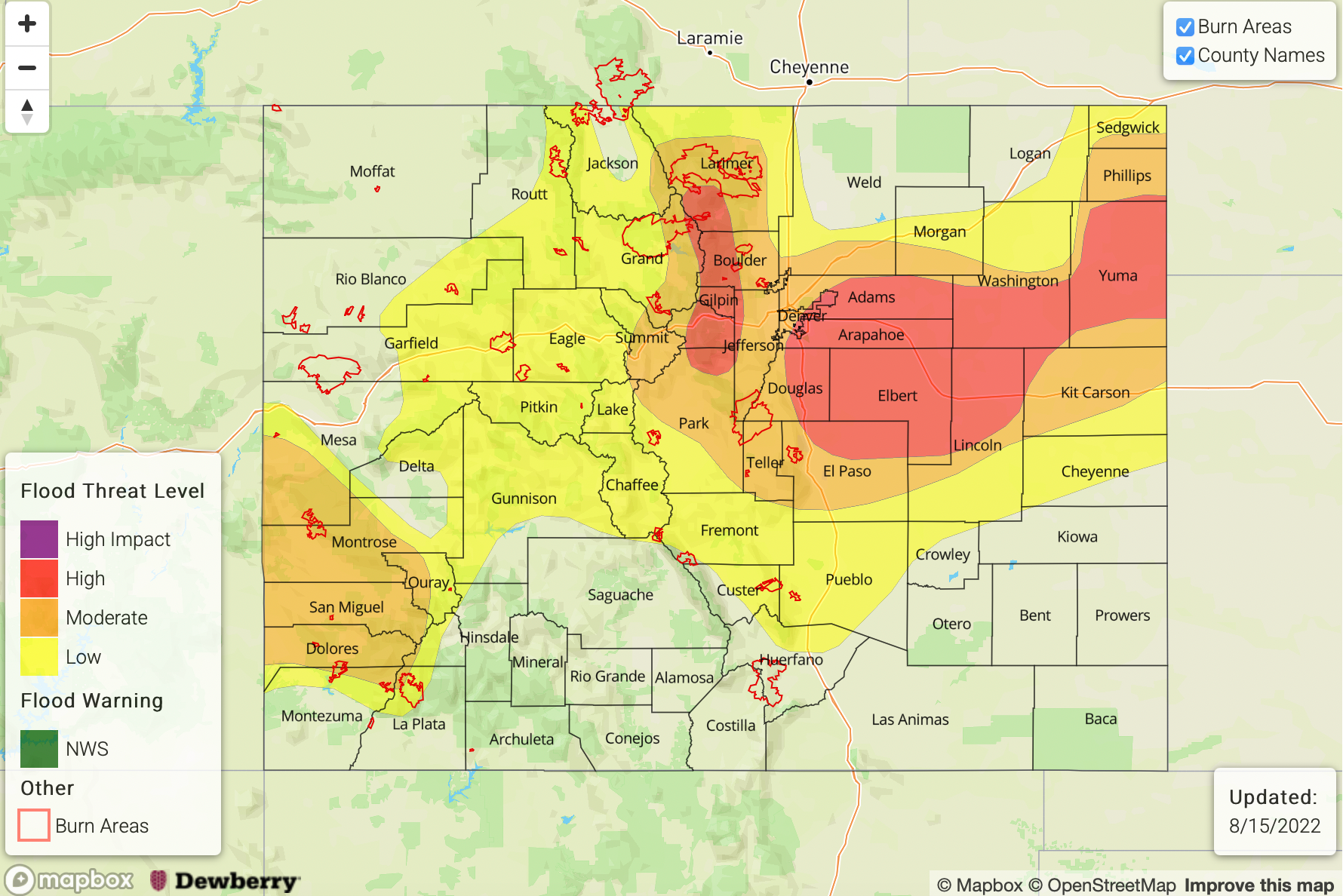
— A HIGH flood threat has been issued for the Front Range and portions of the Urban Corridor, Palmer Ridge and Northeast Plains
— A MODERATE flood threat has been issued for the Southwest Slope and portions of the Central Mountains, Northern Mountains and San Juan Mountains
— A LOW flood threat has been issued for portions of the Southeast Mountains, Southeast Plains, Northwest Slope and Grand Valley
— Fire-Burn Forecast Summary: 4 burn area under HIGH threat; 4 burn areas under MODERATE threat, 2 burn area under LOW threat; click HERE for more info
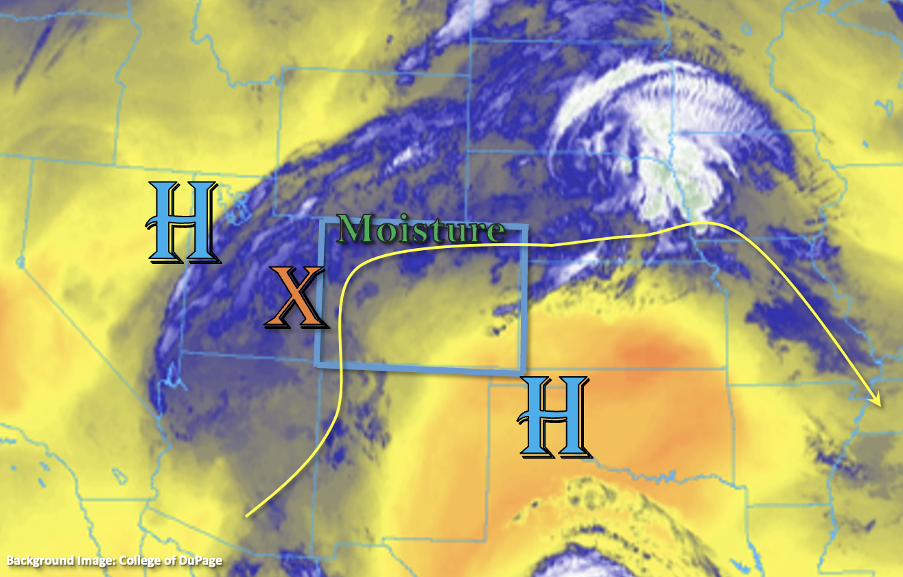
There’s a bit of a change to the synoptic pattern today as the 500mb High to our southeast weakens, and the High centered over the Great Basin begins to build a ridge back to the west. A surface Low is also forecast to develop near the Kansas and Colorado border, which should help pull some monsoon moisture south with northerly flow over portions of eastern and northern Colorado. SSW (south) and WSW (north/central) steering flows should remain weak under the ridging pattern, and storms should become more widespread by this afternoon and evening with some daytime heating, the addition of mid-level energy and enhanced convergence over the adjacent plains.
Moisture is on the upswing across the state with a well-defined monsoon moisture plume still rotating around the High (blue and white below). PW was measured at 1.14 inches and 1.04 inches in Grand Junction and Platteville, respectively, which in the 95th percentile for this time of year! The column of moisture looks impressive in morning soundings, as does the warm layer, so storms should produce some very efficient rain rates with longer duration rainfall and a couple rounds of storms also causing an increase in the flood threat.
Over western Colorado, the flood threat is expected to be greatest over the high terrain in the southwest corner, and a MODERATE threat has been issued. Cloud cover and ongoing rainfall further north may limit the instability that can build, so only a LOW flood threat has been issued for the area and heavy rainfall should be more isolated. Over eastern Colorado, persistent rainfall is anticipated along the Front Range, so a HIGH flood threat has been issued. Additionally, heavy rainfall is likely over portions of the adjacent plains with increased convergence along a developing surface trough and over the Palmer Ridge. A High threat has been issued. There is less confidence of the location and likelihood for heavy rainfall tonight near the eastern border, so a larger MODERATE threat area has been drawn. If storms can move into the area, very high rain rates are expected. The flood threat for eastern Colorado will persist until just after midnight with lighter showers anticipated thereafter. Flood threats today include urban flooding issues (low-lying areas, roads, gulches and small streams), mud flows and debris slides over steeper terrain, and heavy ponding under the storm cores.
Today’s Flood Threat Map
For more information on today’s flood threat, see the map below. If there is a threat, hover over the threat areas for more details, and click on burn areas to learn more about them. For Zone-Specific forecasts, scroll below the threat map.
Zone-Specific Forecasts:
Southeast Mountains, Front Range, Urban Corridor, Palmer Ridge, Northeast Plains, Raton Ridge & Southeast Plains:
In addition to the singular thunderstorm, longer duration rainfall may cause some flooding issues along the Front Range. Max 1-hour rain rates up to 2.5 inches and 3-hour rain rates just under 3.5 inches will be possible. This could cause isolated mud flows and debris slides as well as road flooding. A HIGH flood threat has been issued. Over the Southeast Mountains, the Wet Mountains could see 1-hour rain rates up to 1.25 inches, so a LOW flood threat has been issued. For the adjacent plains, high moisture and enhanced convergence could produce 1-hour rain rates up to 2.5 inches (west) and 3.5 inches (east). A HIGH flood threat has been issued, which persists into the overnight hours. Lighter rainfall may linger through tomorrow morning. In addition to heavy rainfall, stronger storms may produce outflow winds and small hail.
Primetime: 1:30PM to 6AM
San Juan Mountains, Southwest Slope, Central Mountains, San Luis Valley, Northwest Slope, Northern Mountains & Grand Valley:
Ongoing rainfall and cloud cover may limit the flood threat north, but where there are breaks in cloud cover and instability can build, storms that develop could produce very heavy rainfall. A LOW flood threat has been issued. Further south, better moisture, instability and lift are forecast, and a MODERATE threat has been issued for the high terrain in the area. Max 1-hour rain rates up to 1.2 inches (north) and 1.4 inches (south) will be possible with the majority of the rainfall falling in the first 30-45 minutes. A couple rounds of storms south could boost storm totals up to 2.25 inches. In addition to heavy rainfall, thunderstorms may produce small hail and strong outflow winds. Flood threats include road flooding, ponding in low-lying areas as well as isolated mud and debris flows. The flood threat should end later this evening with lighter rainfall likely continuing overnight with mid-level energy moving through the flow.
Primetime: 1PM to 6AM