Issue Date: Sunday, August 14th, 2022
Issue Time: 10:30 AM MDT
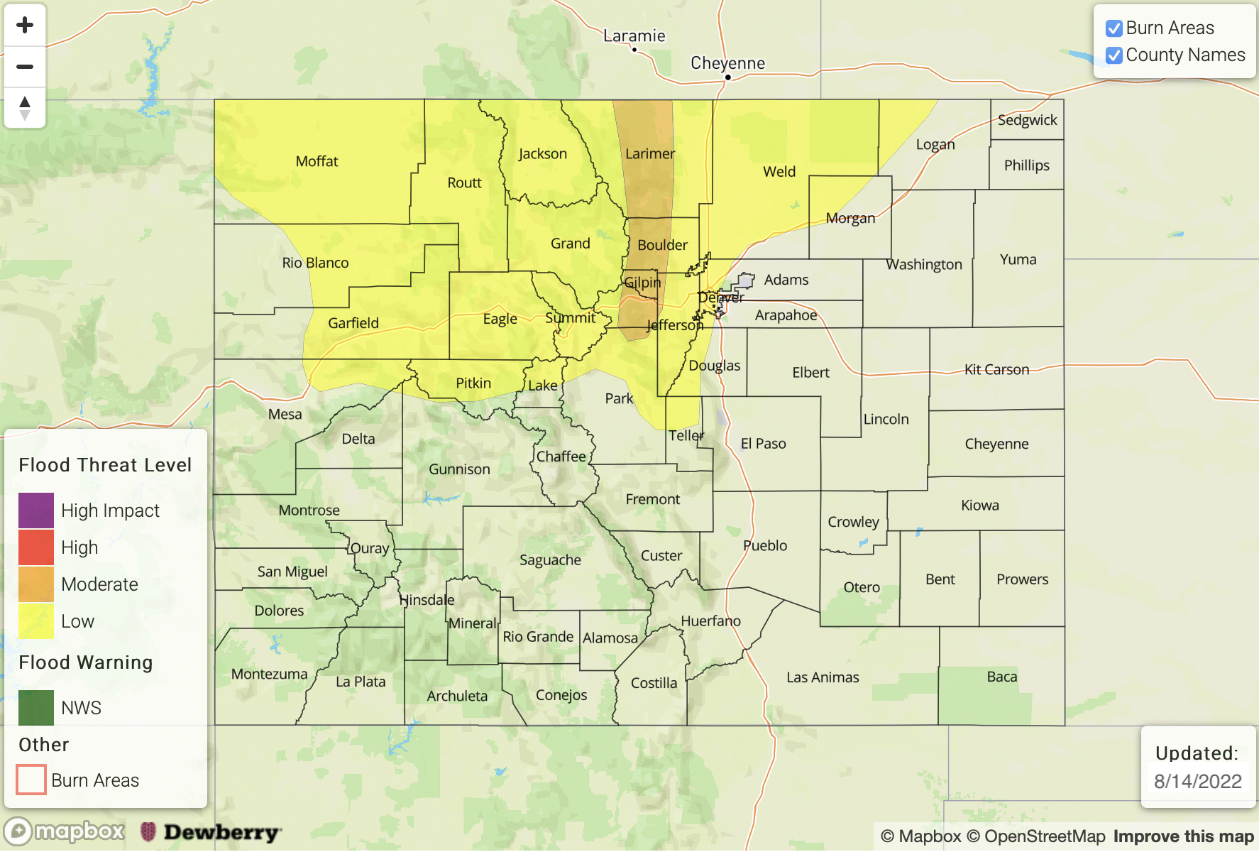
— A MODERATE flood threat has been issued for the Front Range
— A LOW flood threat has been issued for the Northwest Slope, Grand Valley, Central Mountains, Northern Mountains, Urban Corridor, & Northeast Plains
— Fire-Burn Forecast Summary: 3 burn areas under HIGH threat, 3 burn areas under MODERATE threat, 3 burn areas under LOW threat; click HERE for more info
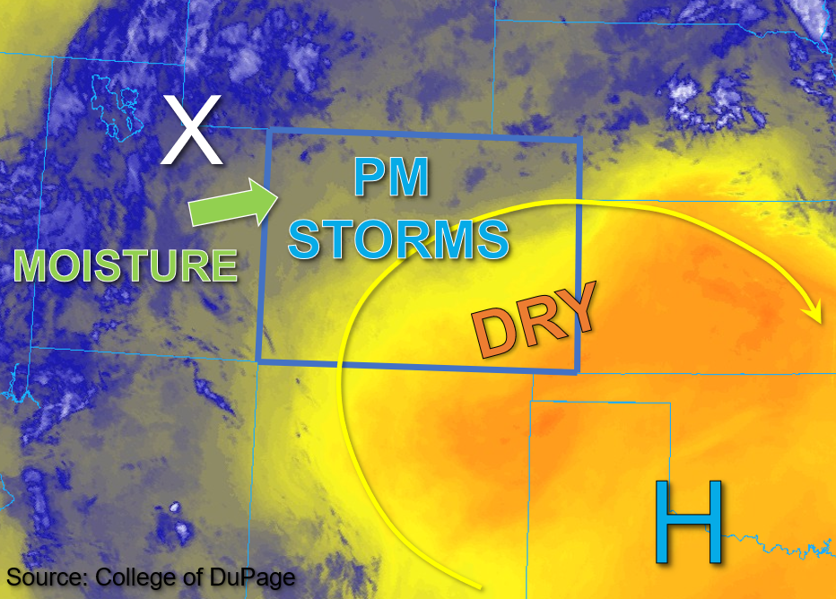
This morning, the high-pressure center is located over southwest Oklahoma after shifting slightly southeast overnight. Its position should remain relatively unchanged or shift slightly back west today. As a result, southwest flow for southern Colorado becomes more westerly further north, along with steering speeds in the 10 to 15mph range. A shortwave disturbance is located over northeastern Utah this morning, marked by the “X” in the water vapor image below, and is forecast to track into northern Colorado by early afternoon. This disturbance, in conjunction with instability ranging from 1500-2000 over the northern-central parts of the state, is expected to trigger scattered to numerous storms over primarily the northern half of the state by early afternoon.
Column moisture has increased overall today compared to yesterday, with Grand Junction measuring a PW value of 1.10 inches and Platteville measuring a PW value of 1.02 inches. Additionally, surface moisture has increased, and dewpoint depressions are much shallower today relative to yesterday, indicating deeper boundary layer moisture throughout. Given the increasing southerly wind component with relatively slow steering flow, the highest concern for flooding exists across the northern Front Range where convergence and training storms are most likely. A MODERATE flood threat has been issued for this forecast zone, while a LOW flood threat has been issued for greater portions of northern Colorado.
Isolated to widely scattered storms may also occur over the high terrain south and west of the Continental Divide, with an isolated storm or two also possible over the Palmer Ridge. Given less instability and moisture and higher dewpoint depressions for these areas, NO flooding is expected for the southern half of the state today.
Today’s Flood Threat Map
For more information on today’s flood threat, see the map below. If there is a threat, hover over the threat areas for more details, and click on burn areas to learn more about them. For Zone-Specific forecasts, scroll below the threat map.
Zone-Specific Forecasts:
Northwest Slope, Grand Valley, Northern Mountains, Central Mountains, Front Range, Urban Corridor, & Northeast Plains:
A few weak showers are beginning to develop over the far Northwest Slope this morning. By early afternoon, scattered to numerous storms are expected to overspread much of northern Colorado. Max 1-hour rain rates for the Front Range (especially above 7,000 feet) could reach up to 1.75 inches, and 3-hour storm totals up to 2 inches are possible, along with the potential for training storms. A MODERATE flood threat has been issued to reflect these higher rain rates forecast. A LOW flood threat has been issued for the Northwest Slope, Grand Valley, Northern Mountains, Central Mountains, Urban Corridor, and Northeast Plains, where 1-hour rain rates up to 1.25 inches and 3-hour storm totals up to 2 inches are possible.
Primetime: 12PM to Midnight
Southwest Slope, San Juan Mountains, San Luis Valley, Southeast Mountains, Raton Ridge, Palmer Ridge, & Southeast Plains:
Clouds are beginning to build over the higher elevations this morning, with mostly clear skies for the rest of southern Colorado. This afternoon, scattered storms are expected over the higher terrain west of the Continental Divide. However, with much less instability to work with, storms are not expected to be of long duration. A few isolated moderate downpours may occur over the western San Juan Mountains and eastern Southwest slope and produce 1-hour rain rates up to 0.75 inches. A few brief, isolated storms may also develop over the higher elevation ridges and produce 30-minute rain rates up to 0.4 inches. Flooding is NOT expected today.