Issue Date: 9/7/2015
Issue Time: 9:30 AM
NO FLOOD THREAT IS FORECAST.
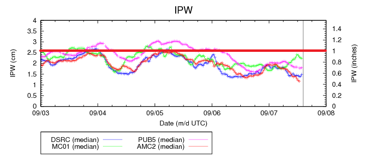
Mother Nature did not get the memo that today is Labor Day, and she is working to bring isolated-to-scattered showers and thunderstorms to Colorado. Overall, activity will show a slight uptick from yesterday, but no flood threat is expected. The IPW graph gives a glimpse into why no flood threat is expected; precipitable water values are below an inch at the four normal reporting stations, and should not increase drastically through the afternoon/evening hours. All in all, these values will lend themselves to low/moderate rainfall rates when combined with the marginal instability for the following regions: Southwest Slope, San Juan Mountains, Northwest Slope, Northern Mountains, Front Range, Southeast Mountains, Grand Valley, San Luis Valley, Urban Corridor, and western portions of the Palmer Ridge/Northeast Plains/Southeast Plains/Raton Ridge.
The exception to the rules outlined above will be across far eastern Colorado, near the CO/KS border. In that area, a surface cool front will remain stalled/become diffuse through the afternoon hours, resulting in a pool of higher dewpoint values and greater instability. Rain rates will be higher there than any other point in the state, maximizing around 1.5-2.0 inches/hour. Easterly storm motions at about 15-20 knots will help limit the flood threat, and thus no flood threat is issued. Street/field ponding, especially in areas that have drainage issues, will be a concern under brief heavy rainfall. Other threats will be strong, gusty winds (45-55 mph), lightning, and small hail (up to 1 inch in diameter).
Today’s Flood Threat Map
For more information on today’s flood threat, see the map below (hover over threat areas for more details). For Zone-Specific forecasts, jump below the map.

Zone-Specific Forecasts
Urban Corridor, Northeast Plains, Raton Ridge, Palmer Ridge, and Southeast Plains:
Isolated-to-scattered showers and thunderstorms today and tonight, ending from west to east as drier air filters in amid westerly flow aloft. For most areas, max rain rates will be 0.25-0.5 inches/hour. Near the CO/KS border, however, maximum rain rates will be 1.5-2.0 inches/hour.
Timing: 2 PM – Midnight, with a few showers/weak thunderstorms continuing into the early morning hours across the Northeast Plains, Southeast Plains, and Palmer Ridge.
Front Range, Northern Mountains, Northwest Slope, Central Mountains, San Juan Mountains, Southwest Slope, Grand Valley, San Luis Valley and Southeast Mountains:
Isolated-to-scattered showers and weak thunderstorms are expected, with the greatest coverage across the higher terrain along and north of I-70. Westerly steering winds aloft will help push storms over adjacent valleys, but during the evening as drier air filters in, storms will become more anchored to the higher terrain. Rain rates will be low, generally 0.15-0.3 inches/hour, and maximizing around 0.4-0.6 inches/hour.
Timing: Current – 9 PM, with a couple isolated showers lingering into the early morning hours.