Issue Date: Thursday, August 11th, 2022
Issue Time: 10:15 AM MDT
Summary:
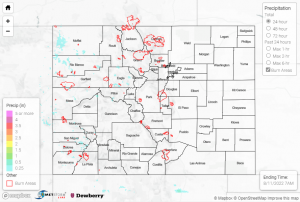
Rainfall seemed to continue the trend from yesterday. The eastern half of the state saw no precipitation outside of a few reports of under 0.1” around the Urban Corridor. The west was a little more active, although most areas still received less than 0.15” if they received any precipitation. A severe thunderstorm warning was issued from 4:30 pm – 5 pm over the Colorado-Utah border east of Moab, but no flooding or severe weather was reported. This area received 0.12” according to a Mesowest gage, and Grand Junction to the north saw up to almost 0.1”. Areas where precipitation observations stayed below about 0.1” include Durango, Placerville, Gypsum, and El Jebel.
0.38” near Dolores, 0.39” northwest of Rifle, and 0.24” north of Minturn were among the highest totals for Colorado yesterday. There was a Flood Advisory issued north of Eagle, from 6:36 pm – 9:45 pm, but no flooding was reported.
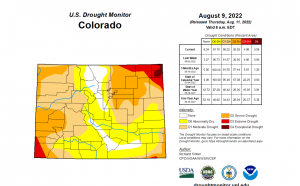
The newest U.S. Drought Monitor update was released, shown as the image below. Due to the weekend’s significant rainfall, there was a decrease of land in most of the drought categories, from “None” to “Severe”. The percentage of area with no drought increased from 3.27% to 8.24%! The Abnormally Dry category decreased from 96.73% to 91.76%, and there were also decreases in the Moderate and Severe drought categories by approximately 4% – welcome improvements to conditions across Colorado.

There was no flooding reported yesterday.
If you observe flooding in your area, remember to use the “Report a Flood” page to make any flood reports when you can safely do so. For precipitation estimates in our area, check out the map below.
