Issue Date: Tuesday, August 9th, 2022
Issue Time: 9:00 AM MDT
Summary:
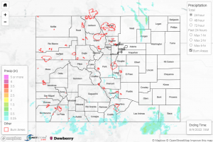
Monday saw relatively quieter weather compared to Sunday’s widespread heavy rainfall and flooding. Isolated to widely scattered showers and storms developed with daytime heating by mid-afternoon across mainly the southern half of the state, with storms remaining confined to the high terrain.
The heaviest rain was observed across the far southern Front Range, and southwestward and southeastward from there across the southern mountains and foothills. QPE data indicates amounts were generally in the 0.5”-1.5” range, with notable observations of 0.95” west of La Veta and 0.58” north of Pagosa Springs from automated gauges. Several Flash Flood Warnings were issued along the southern I-25 corridor, although no flooding was reported. One of the warnings was for portions of northeast Fremont/southwest Teller Counties west of Colorado Springs, with a CoCoRaHS observer reporting 0.72” of rain and hail up to 0.5” near Cripple Creek. The other two warnings were issued for north central Custer County and for the Spring Creek burn scar.
For the northern half of the state, the only noteworthy precipitation was from isolated cells that tracked into eastern Weld County, prompting a Severe Thunderstorm Warning; no reports of severe weather were received. Rain gauge coverage is sparse, but QPE data suggests a narrow swath of up to 1.5” of rain from eastern Weld into northwestern Morgan Counties.
If you observe flooding in your area, remember to use the “Report a Flood” page to make any flood reports when you can safely do so. For precipitation estimates in our area, check out the map below.
