Issue Date: Monday, August 8th, 2022
Issue Time: 11:45 AM MDT
Summary:
As anticipated, yesterday was a very active day across Colorado. By late morning scattered showers developed over the Northeast Plains and Palmer Ridge along a weak frontal boundary dipping into the state from the northeast to southwest. In the afternoon, isolated to widely scattered storms began firing up in the high elevations of the Front Range, Central and San Juan Mountains, Raton Ridge, and Southeast Plains; scattered storms also developed in the Southwest Slope. These storms quickly increased in coverage and intensity, spilling onto the Southeast Plains and tapping into moisture funneling in from southwest along the stalled frontal boundary draped across the southeast quadrant of state. In the evening, strong thunderstorms developed along the Front Range, Urban Corridor, Southeast Mountains, Raton Ridge, and Southeast Plains. General drying occurred from north to south as storms began to taper off overnight for the Urban Corridor. Showers and thunderstorms remained overnight for the Palmer Ridge and Southeast Plains. Lingering moisture overnight and this morning resulted in many waking up to dense fog across the Eastern Plains.
A total of 27 flood warnings or advisories were issued across the state yesterday and wide swaths of heavy rain was reported from Fort Collins to Walsenburg and Pueblo to Kit Carson! In addition to the many flood warnings, several severe thunderstorm and tornado warnings were issued for the Eastern Plains. Torrential rainfall also occurred with the severe thunderstorms, making them particularly dangerous with a combination of high winds, large hail, heavy rain, and several reported funnel clouds.
The Cameron Peak and Spring Creek burn scars were the two scars most threatened by heavy rain yesterday and both were issued flash flood warnings for all or portions of each scar. A CoCoRaHS gauge near Livermore in Larimer County reported 1.00 inches of rain yesterday, accompanied by up to 0.75 inch hail. Thankfully no flooding was reported on either of these scars, though there were still plenty of flood reports across Central and Southern Colorado.
In La Plata county, a “mudslide occurred north of the Vallecito Marina and Yacht Club as a result of heavy rain from thunderstorms”. The Vallecito Reservoir and Vallecito Creek MesoWest gauges only reported 0.01 and 0.06 inches of rain, respectively, but CoCoRaHS observers in Bayfield (south of the reservoir) reported between 0.32-0.48 inches of precipitation yesterday, and the Durango area received up to 0.70 inches of rain. A bit further west in Cortez, up to 0.87 inches was reported along with “minor flooding on local fields and ditches”.
In Alamosa, a CoCoRaHS observer reported 0.70 inches of rain from a “heavy thunderstorm” that caused street and parking lots to flood.
On Poncha Pass in the Central Mountains, a “boulder the size of an engine” was reported to have fallen on Highway 285. Nearby rainfall reports are modest, ranging from only 0.09-0.13 inches. However, 72-hour QPE for this area suggests up to 0.50-1.00 inches of rain have fallen in this area in the last few days.
In Walsenburg, Huerfano County Road 340 was reported flooded by law enforcement. Impressive rainfall totals of 1.75 inches and 2.20 inches were reported in or near Walsenburg and Lathrop State Park.
Multiple flood reports were made across the Denver Metro Area and Urban Corridor last night, including:
- Street flooding at Colfax Ave and Monaco Parkway from hail covering street drainage. There were reports of up to 6 inches of water running across the road and 0.75 inch hail stones
- Multiple roads flooded in City Park area east of Denver
- A newly constructed portion of I-70 was closed between York St. and Brighton Blvd. due to floodwaters, stranding several vehicles and prompting rescue from Denver Fire (tweet below)
- Reports of nuisance flooding and water ponding on roads in Thornton, Westminster, Aurora, and Commerce City
Floodwater blocking I-70 between York and Brighton! Traffic at a complete standstill #Denver #cowx pic.twitter.com/IINXxdn0nb
— Chris Riske (@RiskeChris) August 8, 2022
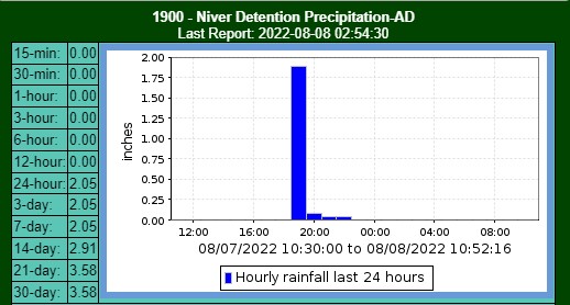
Most of the Metro Area flooding was a result of very quick, very intense storms over impervious surfaces where most of the rainfall was translated to runoff. A MHFD gauge at Niver Detention Pond in Thornton (below) picked up 2.05 inches yesterday, with over 1.75 of that falling in a single hour. The 25-year, 1-hour ARI precipitation in Thornton is 1.77 inches – so this storm was just below a 25-year ARI. In other words, there was just a 4% chance of a storm of this magnitude occurring in any given year!
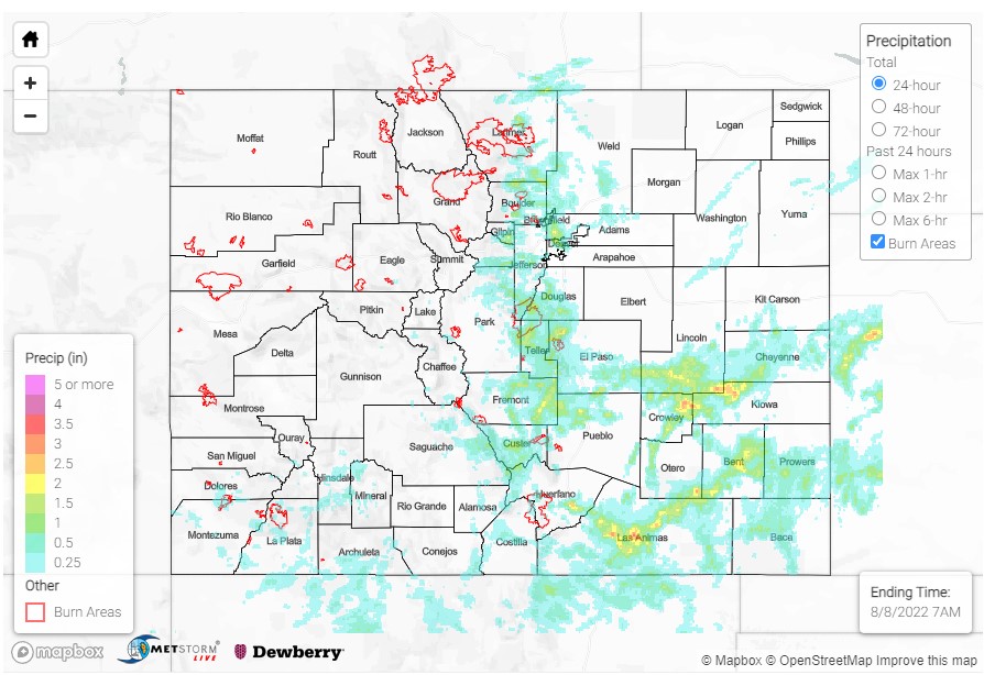
Across the Urban Corridor rainfall totals vary wildly, with some locations picking up impressive totals and others completely missed. Some highlights for the Urban Area/Front Range include:
- 1.71 in Berthoud
- 1.71 in Westminster
- 1.63 in Lyons
- 1.60 in Kittredge
- 1.27 in Niwot
- 1.18 in Broomfield
- 1.05 in Conifer
- 1.01 in Hygiene
- 0.95 in Sedalia
- 0.85 in Windsor
West of Colorado Springs, a debris flow was reported in Divide with rocks on Highway 24 between Lower Twin Rocks Road and Jade Road. A CoCoRaHS observer in Divide reported up to 0.71 inches of rain, but a nearby observer in Florissant reported 2.29 inches yesterday! In Colorado Springs itself, there were several reports made on social media of water flowing across residential roads, and rocks/mud washed onto Hay Creek Road.
A bit further south in the Florence-Canon City-Penrose area, flooding was reported along Highway 115 near Pathfinder Park, along County Road 13A, and debris flows were reported on Highway 67 north of Highway 50, and on Highway 50 itself around Mile Marker 228 (west of Canon City). A CoCoRaHS observer in Penrose reported 1.95 inches of rain yesterday, and the Freemont County Airport reported 1.42 inches.
Lastly, heavy rain caused multiple flooded roadways across the northern and western portions of Pueblo West, stranding at least one vehicle. There was also a “100-foot wide channel of flowing water through properties – at least several inches deep” reported. Between 1.32-1.82 inches of rain were reported by CoCoRaHS observers in Pueblo West Yesterday.
Other notable totals across Southern Colorado:
- 2.72 in Haswell
- 2.50 in Model
- 2.18 in La Junta
- 2.15 in Karval
- 1.95 in Penrose
- 1.75 in Westcliffe
- 1.74 in Colorado Springs
- 1.50 in McClave
- 0.68 in Chromo
- 0.65 in Pagosa Springs
Remember, if you observe flooding in your area please use the “Report a Flood” page to make any flood reports when you can safely do so. For precipitation estimates in our area, check out the map below.

