Issue Date: Sunday, August 7th, 2022
Issue Time: 11:50 AM MDT
Summary:
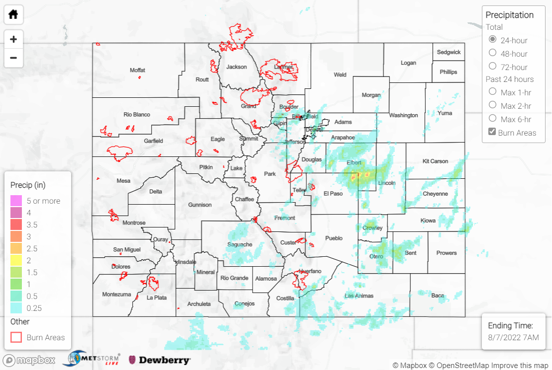
Saturday featured continued showers and storms, although increasingly drier mid-level air limited precipitation coverage to mainly the southeast half of the state. Convection initiated over the Palmer Ridge and foothills of the southern mountains/central Front Range by late afternoon, with storms subsequently tracking northeastward into the Plains.
The heaviest rain was observed over the Palmer Ridge and Southeast Plains; for the Palmer Ridge, QPE indicates amounts of up to 3” across northeast El Paso/southeast Elbert Counties, while for the Southeast Plains, QPE indicates amounts of up to 2” for portions of Crowley, Otero, and Bent Counties. One Flash Flood Warning and three Severe Thunderstorm Warnings were issued south of Limon, with an 80-mph gust and shingles torn off houses reported near Kutch. Notable rainfall totals in this area include 3.14” and 2.50” south of Simla and 1.75” near Ramah. Near La Junta and Las Animas, a Flash Flood Warning and several Severe Thunderstorm Warnings were issued; Highway 50 was reported as flooded between Reynolds Avenue and County Road 24 and at mile marker 394. An underpass was reported flooded in La Junta, with an 87-mph gust measured at an automated station near Cheraw; multiple power poles were also reported down. Near the Kansas border, a Severe Thunderstorm Warning was issued south of Burlington, with a 52-mph gust and nickel-sized hail reported.
Across the central Front Range and Urban Corridor, QPE indicates rainfall amounts of up to 1.75”. Penny-sized hail was reported in Denver, along with 0.95” of rain falling in just 20 minutes, which has an estimated ARI of about 14 years! Other notable rainfall totals include:
• 1.66” and 1.28” near Nederland
• 1.14” in Denver
• 1.14” near Brighton
• 0.84” near Broomfield
Heavy rain was also observed over the southern mountains and foothills, with localized totals of up to 1.50” per QPE data. Rain gauge observations include 1.31” west of Antonito, 1.01” north of Del Norte, and 0.74” in Trinidad.
If you observe flooding in your area, remember to use the “Report a Flood” page to make any flood reports when you can safely do so. For precipitation estimates in our area, check out the map below.
