Issue Date: Sunday, August 7th, 2022
Issue Time: 10:40AM MDT
— The flood threat will persist into the overnight hours
— A HIGH flood threat has been issued for the Urban Corridor, Palmer Ridge, Southeast Mountains and Southeast Plains
— A MODERATE flood threat has been issued for the San Juan Mountains, Raton Ridge, Front Range and Northeast Plains
— A LOW flood threat has been issued for the Central Mountains
— Fire-Burn Forecast Summary: 1 burn area under HIGH IMPACT threat, 2 burn areas under HIGH threat, 1 burn area under MODERATE threat; click HERE for more info
There will be quite the pattern shift today as a trough passing to the north will flatten out the ridge. The ridge begins to rebuild itself back to the west by this evening, which should give storms more southerly (south) and easterly (north) movement this afternoon and evening. As the trough continues to move east throughout the day, it is expected to continue to push a weak cool front southward across the state. This boundary, as is typical during the summer, will likely stall somewhere over the Palmer Ridge, and may help to produce a couple severe thunderstorms over the plains later today. Post-frontal upslope flow is anticipated over the eastern mountains, and with the jet closer to the upper-level Low, slow steering flows for the numerous to widespread storms that develop will likely cause very heavy rainfall to be generated in their cores.
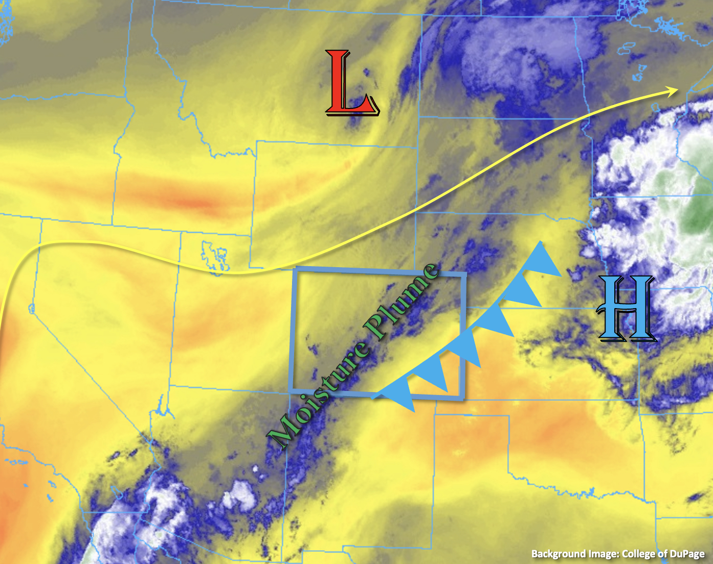
It is still quite moist over eastern Colorado with PW at Platteville measured at 1.02 inches this morning, and dew points in the upper 50°Fs to low 60°Fs. At North Platte, PW was measured at 1.73 inches, so there’s a strong, increasing moisture gradient over the eastern plains. Upslope flow across the plains is expected to hold this high moisture intact. With a well-defined warm layer depth, rainfall efficiency is expected to produce some high rain rates, and a couple round of storms could potentially increase totals, if they track over the same area. This will be mostly likely to occur over the mountains and immediate adjacent plains. Over the eastern plains, enhanced convergence over the elevated ridges and along the boundary may allow storms to anchor to an area and drop some very high totals over a 2 to 3 hour period. Due to the widespread nature of the heavy rainfall and efficient rain rates forecast, a HIGH flood threat has been issued. There will also be an increased risk for rapid rises in local streams/creeks, gulches and arroyos where the storms remain stationary and over impervious areas.
Drier air remains over northwest Colorado with PW at Grand Junction measured at 0.83 inches, which will keep rainfall chances low for the area again today. With the main moisture axis over the San Juan Mountains and mid-level lift moving through the flow, heavy rainfall is anticipated for the area. Saturated soils will increase the risk for mud flows, debris slides and excessive runoff. For this reason, a MODERATE flood threat has been issued.
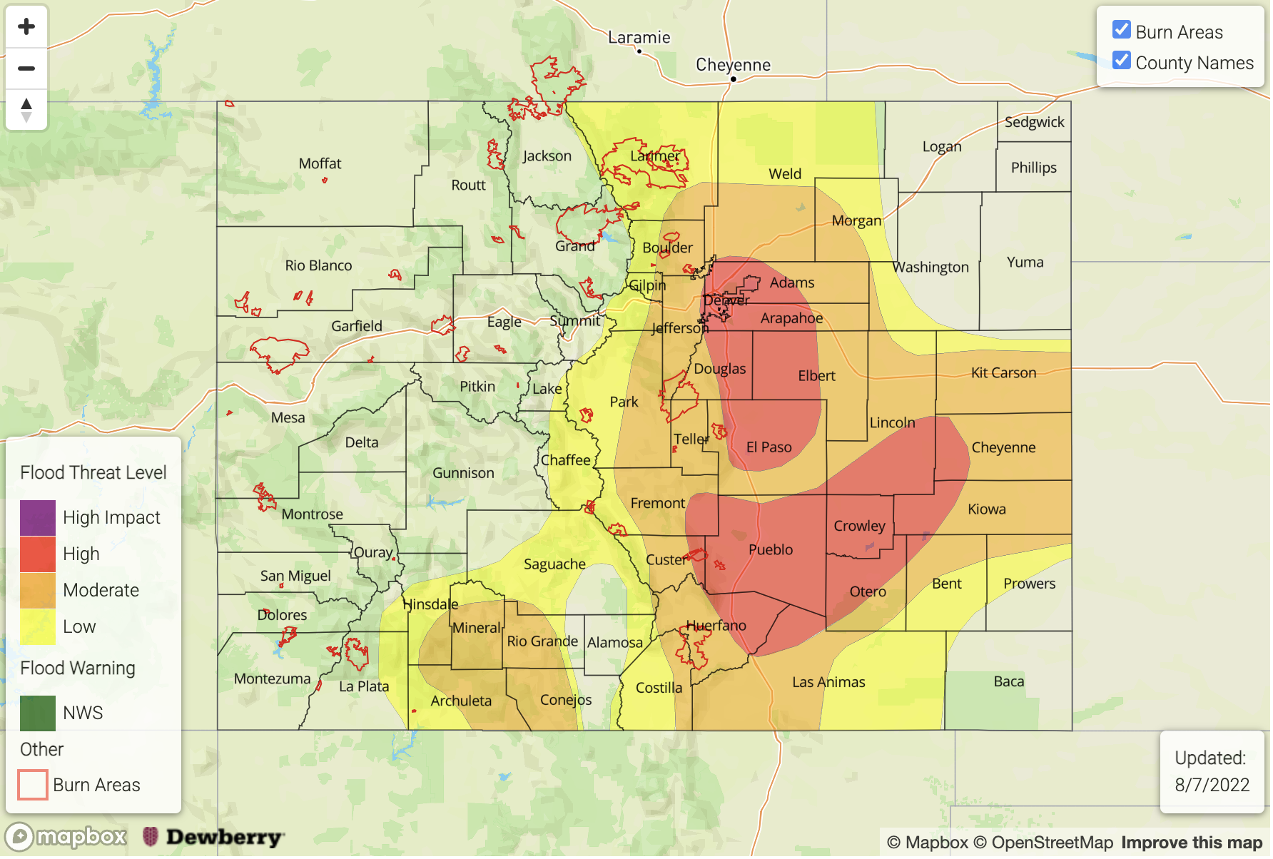
Today’s Flood Threat Map
For more information on today’s flood threat, see the map below. If there is a threat, hover over the threat areas for more details, and click on burn areas to learn more about them. For Zone-Specific forecasts, scroll below the threat map.
Zone-Specific Forecasts:
Southeast Plains, Southeast Mountains & Raton Ridge:
As storms move off the mountains this afternoon, they should encounter high moisture, which should allow for upscale growth. In addition to slow steering flows, storms are likely to develop along a boundary, which could cause heavy rainfall over the course of a few hours. Thus, this is an overnight threat with lighter showers likely lingering through tomorrow morning. Max 1-hour rain rates up to 3 inches and isolated storm totals up to 5 inches will be possible, so a HIGH flood threat has been issued. A couple stronger thunderstorms may develop which would be capable of producing large hail and wind, and wind should become the dominate threat by later this evening. Flood threats today include road flooding, heavy field ponding, flooding of low-lying areas, arroyos and rises in local streams and rivers. Do not attempt to drive through high water and be sure to stay tuned to your local NWS office for the latest on warnings that are issued.
Primetime: 1:30PM to Ongoing
Front Range, Urban Corridor, Palmer Ridge & Northeast Plains:
Widespread heavy rainfall is anticipated with the storms that develop this afternoon. Initially over the mountains, storms should be more scattered, and as the move east into deeper moisture, upscale growth is expected. Some areas may receive rainfall from a couple storms, which would help to boost local storm totals. Max 30-min rain rates up to 2.2 inches and 1-hour rain rates up to 2.75 inches will be possible under the strongest storms that develop. Over impervious areas, this could cause excessive runoff, road flooding and rises in local streams, creeks and dry gulches. Over steeper terrain, mud flows and debris slides will also be possible. A HIGH flood threat has been issued. In addition to heavy rainfall, small hail and outflow winds could occur under the stronger thunderstorms that develop. Use caution near underpasses this afternoon/evening and do not attempt to drive through high water.
Primetime: 12:30PM to 11PM
San Juan Mountains, Central Mountains, Southwest Slope, San Luis Valley, Northwest Slope, Northern Mountains & Grand Valley:
Similar to yesterday, little to no precipitation is forecast over the central/northern portions of these zones with drier air remaining over the area. Further south, moisture and mid-level lift will allow scattered storms to develop over the high terrain favoring the San Juan Mountains for accumulation. Max 1 to 2 hour totals up to 1.75 inches and 30-minute rain rates up to 1.2 inches will be possible. With saturated soils over the area, there will be an increased risk for rises in local streams/creeks, road flooding, mud flows and debris slides. A MODERATE flood threat has been issued. Light showers may linger over the mountains tonight, but the flood threat should end a couple hours after sunset.
Primetime: 12:30PM to 4AM