Issue Date: Saturday, August 6th, 2022
Issue Time: 10:35AM MDT
— A MODERATE flood threat has been issued for the Palmer Ridge and portions of the Northeast and Southeast Plains
— A LOW flood threat has been issued for the Raton Ridge and portions of the San Juan Mountains, Front Range and Southeast Mountains
— Fire-Burn Forecast Summary: 1 burn area under MODERATE threat, 3 burn areas under LOW threat; click HERE for more info
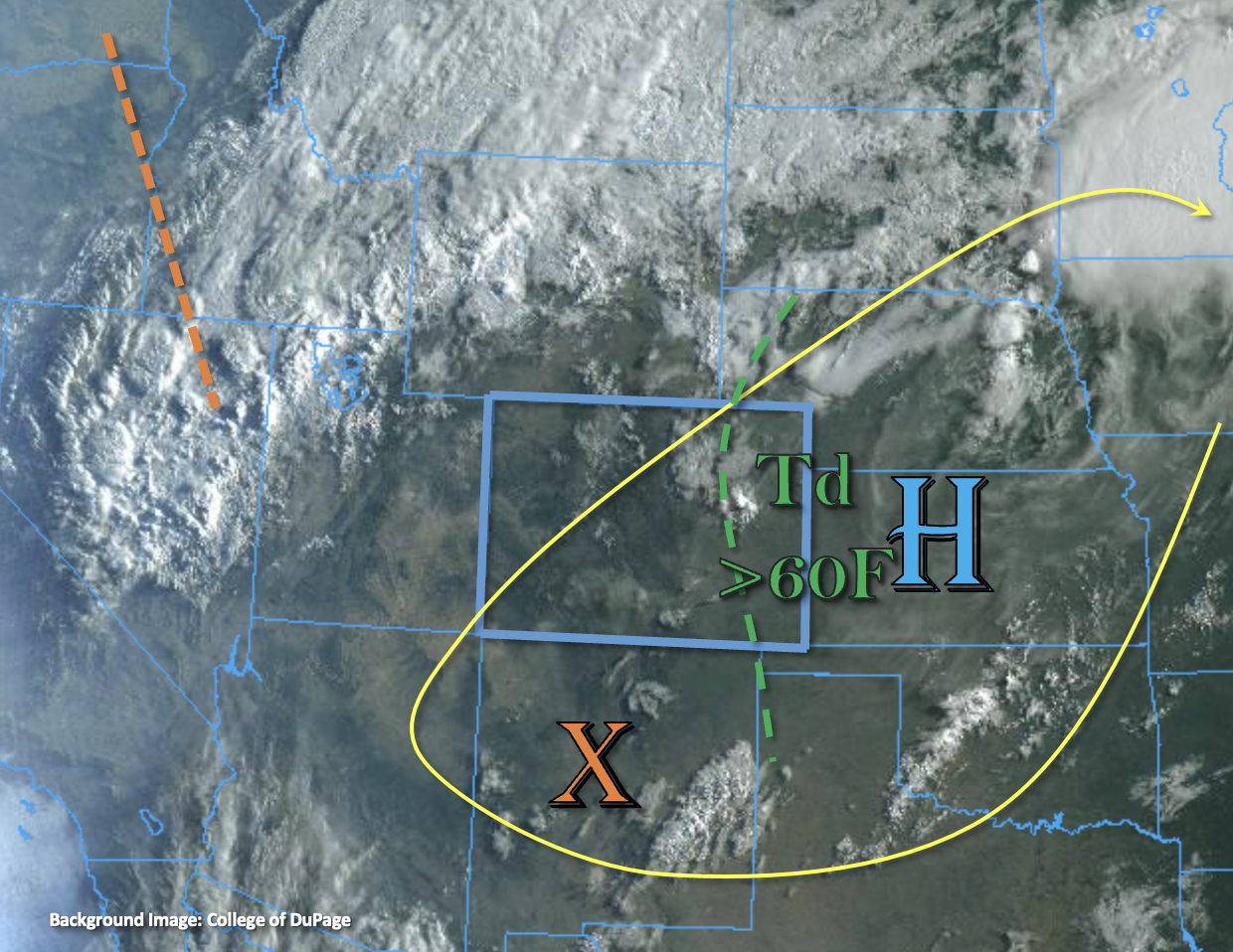
Drawn in this morning’s visible satellite imagery is the elongated High to our east and an incoming trough from the west (orange dashed). Also marked in the image are the 60°F dew points, and PW values across the eastern plains are estimated as high as 1.4 inches. PW at Platteville was measured at 1.25 inches, which is quite high and about a quarter of an inch jump from yesterday. Back over western Colorado, PW at Grand Junction was measured at 0.85 inches with values increasing to an inch across the southern border. A quick way to sum up the moisture content – the monsoon moisture plume remains overhead. While the majority of the lift will remain west and north of the state today with the trough, there was a small shortwave noted in New Mexico (orange “X”), which is expected to move northwards. As it encounters daytime heating and the monsoon moisture, it should help to produce scattered storms this afternoon and evening favoring the eastern and southern high terrains for development. With southwest steering flows around the High, spillover of thunderstorms into the adjacent eastern plains is anticipated.
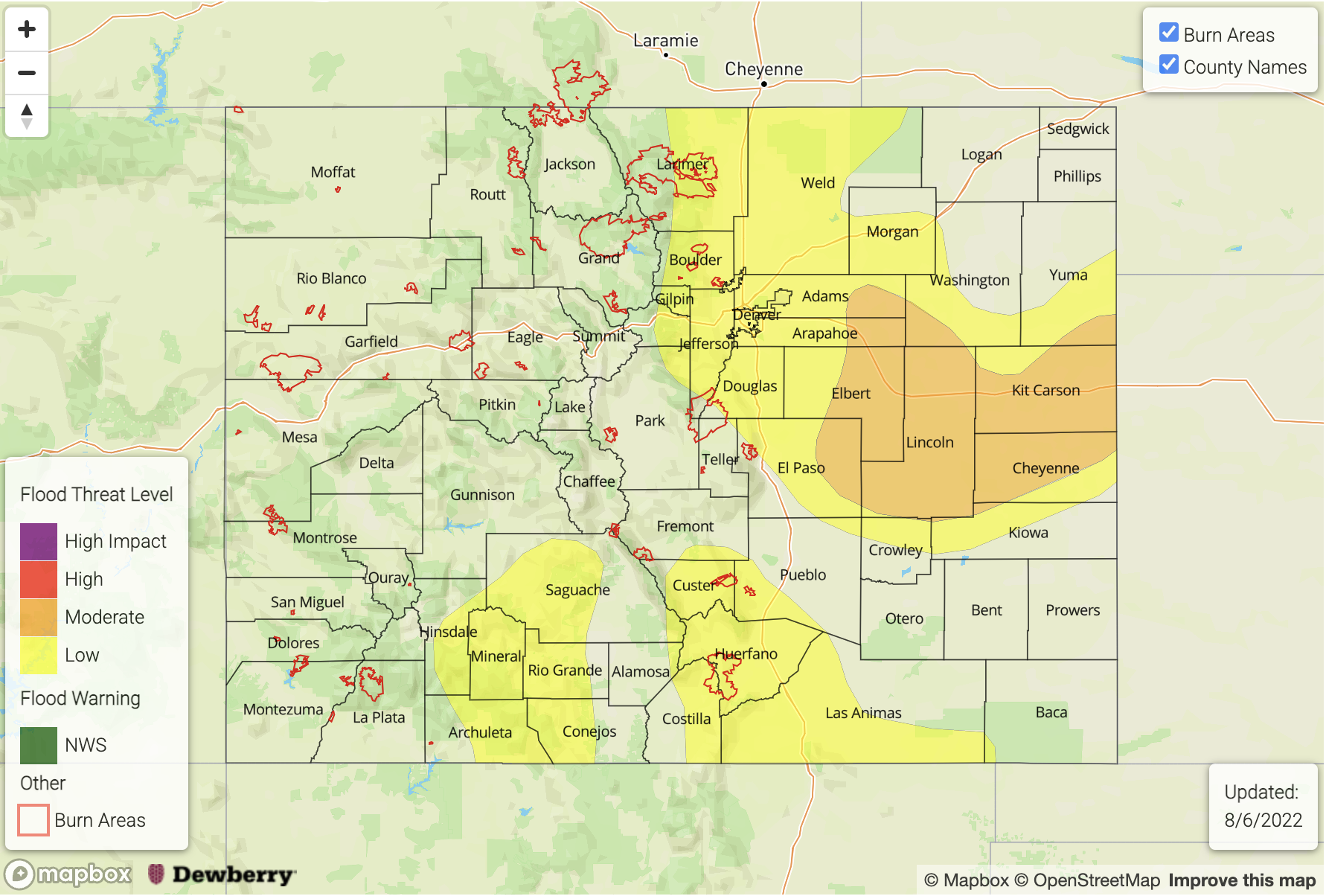
There will be a couple of areas to watch for the flood threat today. Over the mountains, portions of the Front Range, Southeast Mountains and San Juan Mountains may see isolated, heavy rainfall from a couple thunderstorms that develop. If storms (south) track over areas that have saturated soils, there is an increased likelihood for a mud flow, debris slide or excessive runoff. A LOW flood threat has been issued. Over the adjacent plains, enhanced convergence is forecast over the Palmer Ridge, an area with high atmospheric moisture content. So, upscale growth of storms are anticipated in this area with outflow boundaries likely initiating additional storm develop. A MODERATE flood threat has been issued with a LOW threat issued for the Raton Ridge. Stronger storms over these areas may generate road flooding, field ponding and flooding of low-lying areas. In addition to heavy rainfall, a couple storms over eastern Colorado may produce strong wind gusts and hail.
Today’s Flood Threat Map
For more information on today’s flood threat, see the map below. If there is a threat, hover over the threat areas for more details, and click on burn areas to learn more about them. For Zone-Specific forecasts, scroll below the threat map.
Zone-Specific Forecasts:
Palmer Ridge, Northeast Plains & Southeast Plains:
Heavy rainfall is anticipated with thunderstorms that move into portions of these zones this afternoon and evening. Initially some storms may pose a small hail threat with wind becoming that dominate threat later this evening. Upscale growth of storms is anticipated and could cause more widespread heavy rainfall over the Palmer Ridge, so a MODERATE flood threat has been issued. Max 30-minute rain rates up to 2 inches and 1-hour rain rates up to 3 inches will be possible. This could cause road flooding, field ponding and flooding of low-lying areas. Rainfall may linger overnight, but the flood threat should end a few hours after sundown. Tomorrow morning expect cloudy and cool conditions behind the passage of a cold front.
Primetime: 3PM to 2AM
Southeast Mountains, Front Range, Raton Ridge & Urban Corridor:
Storms are expected to be more isolated today, especially north with some mid-level drying and heating. Over this area, max 30-minute rain rates up to 1.25 inches will be possible for the stronger storms that can develop. Further south, max 30-minute rain rates up to 1.5 inches (mountains) and 2.25 inches (adjacent plains) will be possible. Over steeper terrains mud flow and debris slides will be possible, and excessive runoff may also cause road flooding, field ponding and rises on local streams/creeks. Storms may linger overnight further south with weak mid-level lift and moisture over the area. A LOW flood threat has been issued.
Primetime: 12:30PM to 2AM
San Juan Mountains, Central Mountains, Southwest Slope, San Luis Valley, Northwest Slope, Northern Mountains & Grand Valley:
Little to no precipitation is forecast over the central/northern portions of these zones with drier air over the area moving in with a small jet streak. Further south, moisture should be able to hang on and a couple stronger storms may develop capable of producing heavy rainfall. This could be problematic if they track over saturated soils. For reference, Lily Pond SNOTEL soils are about 65% saturated. Max 30-minute rain rates up to 1.2 inches and 1-hour rain rates up to 1.4 inches will be possible. A LOW flood threat has been issued. A few storms may track into the SLV with the southwest steering flow and isolated storm totals up to 0.5 inches may be possible along with strong outflow winds.
Primetime: 2PM to Midnight