Issue Date: Friday, August 5th, 2022
Issue Time: 11:25 AM MDT
Summary:
Yesterday was another low to moderate flood threat day across Southern Colorado, and heavy rain and flooding did not take long to materialize. In the late morning high-based, isolated thunderstorms began to fire up in the San Juan and Southeast Mountains, tapping into available monsoonal moisture and diurnal heating. Storms increased in coverage and intensity as the afternoon progressed, as well as development on the Raton Ridge and Southeast Plains. By evening, the most intense storms were along the Southern Front Range, west of Colorado Springs, and spilling onto the Urban Corridor and Palmer Ridge.
Now for the heavy rain and flood reports:
Severe thunderstorms and heavy rain resulted in a flash flood over Highway 24 east of Florrissant last night. A trained spotter in the area reported 2.65 inches of heavy rain and a nearby MesoWest gage in Divide reported 2.61 total. There could be some hail contamination with these precipitation totals, because there was enough pea-sized hail to accumulate and crush some patio furniture in Divide.
#cowx @NWSPueblo #pubspotter TE67 lots of pea sized hail in Divide. Just stopped. pic.twitter.com/YBdoQiMDAO
— JonZ (@JonZenor) August 5, 2022
A bit further south, a severe thunderstorm near Cripple Creek produced up to 0.50 inch hail; a CoCoRaHS observer reported 1.05 inches of rain as well from this severe thunderstorm.
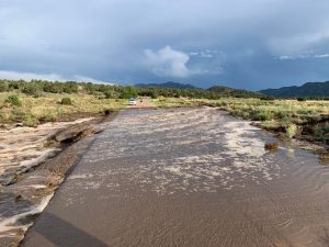
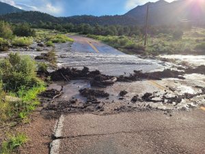
In Freemont County, flooding and debris flows were reported at multiple locations on County Road 28 (Copper Gulch Road). Over 6 feet of “water with mud and debris” was reported at several water crossings located between mile markers 10 and 14. Gauge observations in this area are sparse, and a MesoWest gage at Copper Gulch only reported 0.03 inches yesterday. However, QPE places up to 1.5 inches of rain in this area. Freemont County Emergency Management shared the following images on Facebook of water and debris across the roadway.
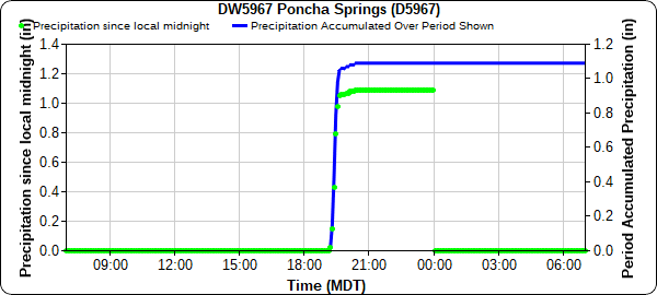
In Poncha Springs and Salida, law enforcement reported significant flooding north of Highway 50 between the two towns. There was also a public report of over 2 inches of rain and flood water entering the garage of their home. Based on the hyetograph below, most of the rain in this area fell in a very short time – this gauge picked up 1.09 inches in just over an hour. Poncha Pass also saw significant flooding with debris flow consisting of boulders on Highway 285. The Decker burn scar is near Poncha Springs/Salida and was included in the issued flash flood warnings, but it doesn’t appear that any of the floods occurred on the burn scar itself.

The Spring Creek burn scar was also issued a flash flood warning yesterday. Stations near La Veta reported between 0.33-0.41 inches of rain, and no flooding was reported on this scar.
On the Southwest Slope, a series of flood warnings were issued including Mesa Verde National Park. The Mesa Verde gauge picked up 0.83 inches of rain. Due to the rural nature of this area of the state, there are limited gages and flood reports elsewhere, but a Dolores gauge in one of the flood warnings picked 2.47 inches over the course of the evening and overnight hours. CDOT also reported rocks on Highway 145, it is unclear if this is heavy rain related, but the rocks were within one flash flood warning polygon.
#CO145 northbound/southbound: Rocks on the road between County Road M44 and FS Rd. 516. Slower speeds advised. https://t.co/yayPmPmj1e
— Colorado Department of Transportation (CDOT) (@ColoradoDOT) August 5, 2022
A few other notable totals in Southern Colorado:
• 1.43 in Kim
• 1.20 in Boncarbo
• 1.13 in Cortez
• 1.05 in Peyton, along with a 0.88 inch hail report
• 0.68 in Gardner
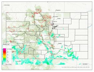
If you observe flooding in your area, remember to use the “Report a Flood” page to make any flood reports when you can safely do so. For precipitation estimates in our area, check out the map below.


