Issue Date: Thursday, August 4th, 2022
Issue Time: 11:10 AM MDT
Summary:
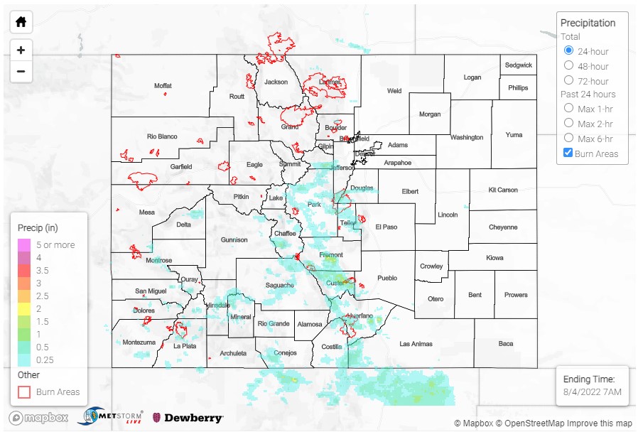
Yesterday saw slightly cooler temperatures for much of the state, which helped to limit some storm potential until later in the day – the exception being on the Eastern Plains and portions of the Grand Valley, which were still quite toasty. Even with cooler temperatures, there was plenty of monsoonal moisture present for widely-scattered storms to fire up along the high terrain of the San Juan, Central, and Southeast Mountains, as well as the Front Range by the afternoon. Generally slower steering flow kept the storms that did develop in place for longer, allowing for heavy localized rainfall. Showers and thunderstorms tapered off shortly after nightfall.
Several flash flood warnings and flood advisories were issued yesterday, particularly for Southern Colorado including the San Juan, Central, Southeast Mountains, Raton Ridge, and Southwest Slope. Several burn scars were also included in the warnings, including the Junkins, Hayden Pass, and Spring Creek burns.
A CoCoRaHS observer near the northern edge of the Spring Creek scar reported 0.60 inches of rain yesterday and left a remark of “street/meadow flooding on Pass Creek Road”. There was also a report of a flash flood in Coaldale with “water rushing over roadway” at the northern extent of the Hayden Pass burn scar. West of that burn, another CoCoRaHS observer in Lake George reported 0.84 inches of rain and “considerable erosion”. The Hayden Pass fire occurred in 2016, which shows how long these burn areas can remain sensitive, especially after several days of consistent rainfall.
Outside of burn areas, there was also a flash flood reported in Texas Creek, where Freemont County sheriff reported a “rock slide on Highway 50 at Mile Mark 261.” On the Mineral-Hinsdale county line, another flash flood and a debris flow were reported due to heavy rain, with “5 feet of standing water on the road…from blocked culvert, causing a vehicle to be trapped”. The debris flow occurred on Highway 149, blocking the northbound lane.
The towns of Poncha Springs and Walsenburg were also included in flash flood warnings. In Walsenburg, a CoCoRaHS observer reported 1.06 inches of rain yesterday, along with small hail.
Some other notable rainfall totals around the state include:
- 1.51 inches in Hartsel
- 0.74 inches in Westcliffe
- 0.61 inches in Evergreen, which came down in just 20 minutes (between 5-10 year 30-minute ARI)
Northern and Southern Portions of Urban Corridor also saw evening showers, including totals up to 0.33 in Castle Rock and 0.39 in Loveland.
If you observe flooding in your area, remember to use the “Report a Flood” page to make any flood reports when you can safely do so. For precipitation estimates in our area, check out the map below.
