Issue Date: Wednesday, July 27th, 2022
Issue Time: 11AM MDT
— A MODERATE flood threat has been posted for the Northeast Plains, Southeast Mountains and San Juan Mountains
— A LOW flood threat has been posted for parts of the Front Range, Urban Corridor, Palmer Ridge, Raton Ridge, Southeast Plains, Central Mountains and Southwest Slope
— The flood threat extends into the overnight hours over northeast Colorado
— A PM update is possible today
— Fire-Burn Forecast Summary: 1 burn area under HIGH threat; 2 burn areas under MODERATE threat; 4 burn areas under LOW threat; click HERE for more info
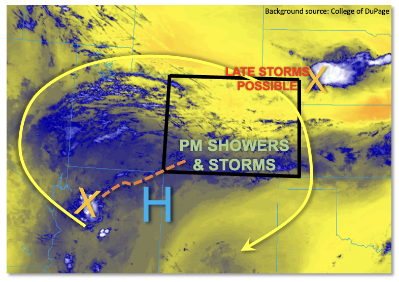
Heavy rainfall will be back in the picture today for many parts of Colorado, though the details are once again tricky to pin down. As shown in the water vapor image, below, the monsoonal upper-level ridge has now moved west over the past 24 hours and is located along the AZ/NM border. With northwest flow across northern Colorado, some subtle drying is trying to work its way over northern and northwestern parts of the state. But this will be limited as upslope flow turns moisture advection back to positive later this afternoon. A very large gradient in moisture was noted this morning with PW at the Platteville research site coming in at a paltry 0.62 inches, while Dodge City, KS measured over 1.5 inches. We expect PW to increase into the 0.9 – 1.4 inch range across eastern Colorado today. Over southern areas, moisture was in the 0.8 – 1.1 inch range with little to no change expected through the day.
A large-scale monsoonal disturbance was noted over the Four Corners. Although the main feature is well southwest of Colorado, a ripple in the flow carries all the way back into southern Colorado. This feature, along with plenty of moisture and instability in the 1,000 – 1,400 J/kg range will support scattered to numerous storms over the southern high terrain this afternoon and evening. A MODERATE flood threat is warranted over the climatologically preferred higher terrain for heavy rainfall primarily over the 30-60 minute duration though some areas could experience up to 3 hours of heavy rainfall.
Further northeast, another remnant disturbance was over western Nebraska, which is causing subsidence in its wake. This feature is actually associated with a poorly defined stationary front that will likely oscillate north/south throughout the day. It is possible that a moist outflow boundary from evening storms could ignite some late evening/overnight convection over the Front Range and Urban Corridor. A LOW flood threat is currently warranted given the uncertainty, but an afternoon update is possible to address this evolving threat.
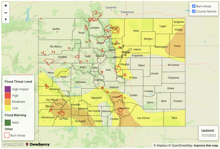
Today’s Flood Threat Map
For more information on today’s flood threat, see the map below. If there is a threat, hover over the threat areas for more details, and click on burn areas to learn more about them. For Zone-Specific forecasts, scroll below the threat map.
Zone-Specific Forecasts:
Northern Mountains, Central Mountains, Grand Valley, San Juan Mountains, Southwest Slope, San Luis Valley, Southeast Mountains, Raton Ridge, Southeast Plains & Northwest Slope:
Mostly sunny with some residual clouds left over the southwest, then turning mostly cloudy with scattered to numerous showers and storms developing by early afternoon. Highest coverage will be over the southern higher terrain. A MODERATE flood threat has been posted for parts of the San Juan and Southeast Mountains for max 30-min rain rates up to 1.0 inch and max 1-hour rain rates up to 1.7 inches. Isolated flash flooding, debris slides and mud flows will all be possible over steeper terrain. A LOW flood threat has been for other southern areas for mainly the threat of isolated flash flooding.
Primetime: Noon through 10PM
Northeast Plains, Front Range, Urban Corridor & Palmer Ridge:
Turning mostly sunny and hot today with widely scattered to scattered showers and storms expected mainly in the late evening and lasting into the overnight hours. A few isolated storms are possible over El Paso County earlier in the afternoon. Max 1-hour rainfall up to 3.0 inches will be possible over far eastern areas, warranting a MODERATE flood threat. Further west, along the Urban Corridor and Front Range, the threat is more conditional, but should storms develop, max 1-hour rainfall up to 2.8 inches is possible. An afternoon update is possible to address this evolving threat.
Primetime: 1PM to 3AM