Issue Date: Tuesday, July 26th, 2022
Issue Time: 10:50AM MDT
— A LOW flood threat has been issued for the Southwest Slope, Northeast Plains, Palmer Ridge and portions of the San Juan Mountains, Urban Corridor and Southeast Plains
— Fire-Burn Forecast Summary: 1 burn area under LOW threat; click HERE for more info
The zoomed-out water vapor imagery below shows a very nice monsoon pattern with clockwise rotation around the High and counterclockwise rotation around the Low pulling a well-defined moisture plume northward from the Pacific Ocean and Gulf of California. A passing trough to the north is still helping to pull in a slightly drier air mass across Colorado’s northern border with northwesterly flow aloft. Today’s setup looks very similar to yesterday’s setup with a few changes to the details. For one, a surface Low is forecast to develop near the CO/NE/KS border, which will help to return the chance for showers and thunderstorms to Northeast Plains and Front Range. Another change will be ongoing cloud cover and downsloping winds over the Southeast Mountains/Southeast Plains, which should somewhat limit the chance for rainfall this afternoon and evening for the area. Over western Colorado, storms should again be confined to the southern high terrains with a more stable air mass north, but there will likely be a slight downtick in storm coverage with the heavy rainfall threat shifting towards the western border and southern San Juan Mountains.
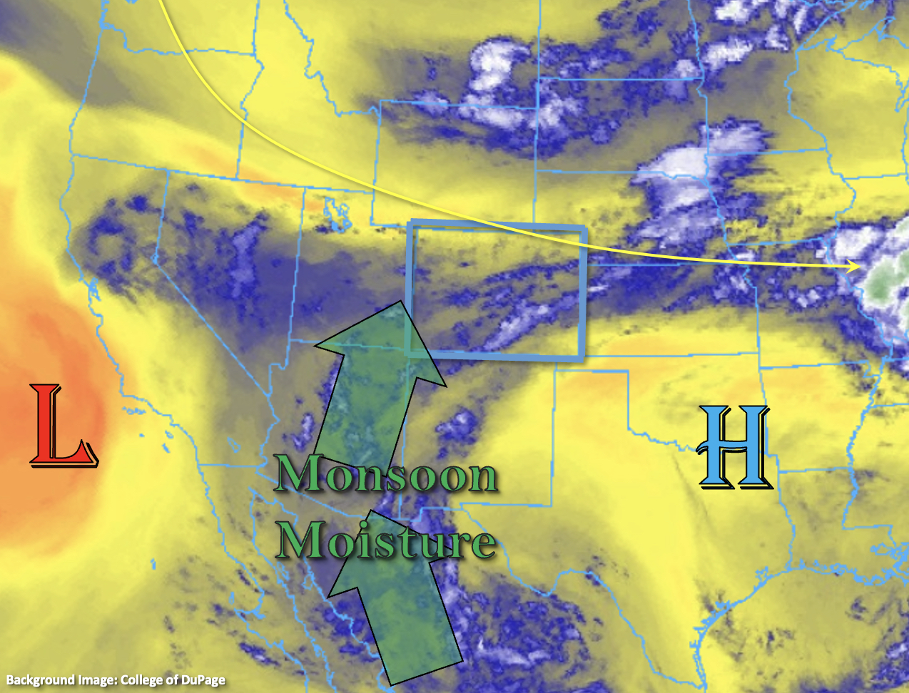
Even with these changes to the synoptic setup, the threat for heavy rainfall remains with monsoon moisture over the state. PW at Grand Junction is just over an inch with slightly higher values likely across the southern border. Longer duration rainfall is again forecast over southwest Colorado where soils are likely saturated from the last couple days of widespread rain. This is especially true over the southern San Juan Mountains, and with isolated convection possible on top of the longer duration rainfall, a LOW flood threat has been issued. The best opportunity for widely scattered, quick downpours today should be closer to the western border where more breaks in cloud cover are likely, which could help some instability to build for stronger convection. So, a LOW flood threat has also been issued for this area.
Over eastern Colorado, dew points are still in the mid-50°Fs to 60°Fs, and with southerly winds forecast over the far eastern plains, this moisture should remain in place. Extra convergence on the south side of the surface Low with the Palmer Ridge could produce a couple stronger thunderstorms over the plains with additional activity possible over the Northeast Plains as storms move off the Cheyenne Ridge and northern Front Range under northwest steering flows. With the cap keeping storm activity isolated, only a LOW flood threat has been issued.
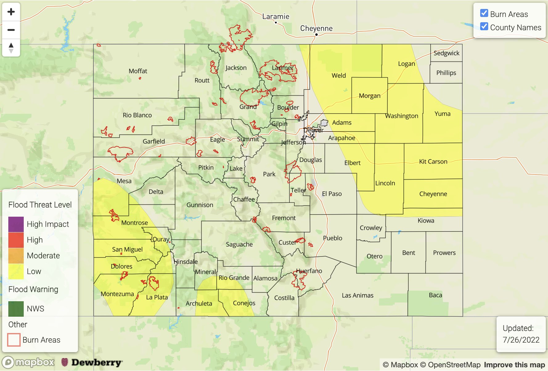
Today’s Flood Threat Map
For more information on today’s flood threat, see the map below. If there is a threat, hover over the threat areas for more details, and click on burn areas to learn more about them. For Zone-Specific forecasts, scroll below the threat map.
Zone-Specific Forecasts:
Northwest Slope, Grand Valley, Southwest Slope, San Luis Valley, Northern Mountains, Central Mountains, Southeast Mountains, Raton Ridge & San Juan Mountains:
Areas over northwest Colorado should remain dry again today, but an isolated weak shower cannot be ruled out over the higher terrains of the Northwest Slope and Grand Valley. Over the Central and northern Southeast Mountains, isolated, weaker storms are forecast with max 30-minute rain rates up to 0.5 inches possible. Closer to the Raton Ridge/Southeast Mountain intersect, max 1-hour rain rates up to 1 inch will be possible.
Longer duration rainfall is forecast for the San Juan Mountains, but the western and southern portions may see some convection along with the high terrains over the Southwest Slope. Max 1-hour rain rates up to 1.25 inches (west) and 1 inch (south) and isolated totals up to 2.25 inches (west) and 1.75 inches (south) will cause a LOW flood threat to be issued. Isolated mud flows and debris slides over steeper terrains as well as road and field ponding will be possible under the stronger storm cores today. The flood threat should end by later this evening, but some light rainfall may linger overnight.
Primetime: 11:30AM to 3AM
Urban Corridor, Front Range, Palmer Ridge, Southeast Plains & Northeast Plains:
It should remain mostly dry over the Southeast Plains with some rainfall anticipated across the southern border. Max 1-hour rain rates up to 1 inch will be possible. Isolated storms are forecast for the Front Range with max 1-hour rain rates up to 0.75 inches possible. Over the adjacent plains, there’s a fairly strong cap overhead plus limited upslope flow, but a couple isolated storms may occur. Max 1-hour rain rates up to 2.75 inches would be possible in the high moisture environment, but only if storms can break through the cap. For this reason, a LOW flood threat has been issued. Flash flood threats would include localized road and low-lying area flooding as well as heavy field ponding under the stronger storms that develop. A severe storm could produce damaging outflow winds and hail. The flood threat should end by midnight, but some overnight, lighter rainfall may be possible.
Primetime: 2PM to 5AM