Issue Date: Monday, July 25th, 2022
Issue Time: 10AM MDT
— A MODERATE flood threat has been issued for portions of the San Juan Mountains, Southwest Slope, Palmer Ridge, Southeast Mountains, Front Range & Urban Corridor
— A LOW flood threat has been issued for the Central Mountains, Raton Ridge and Southeast Plains.
— Fire-Burn Forecast Summary: 2 burn areas under MODERATE threat; click HERE for more info
The disturbance from yesterday has now moved east of the state into Kansas and Nebraska as shown by the orange “X” in the visible satellite imagery below. As the disturbance to our north moves southeastward throughout the day, moderate westerly flow aloft is forecast for the northern half of the state. This will help to continue pulling in a drier air mass, which is show by the lack of cloud cover over southern Wyoming and northern Utah. As a response, there should be a decrease in rainfall activity over this portion of the state.
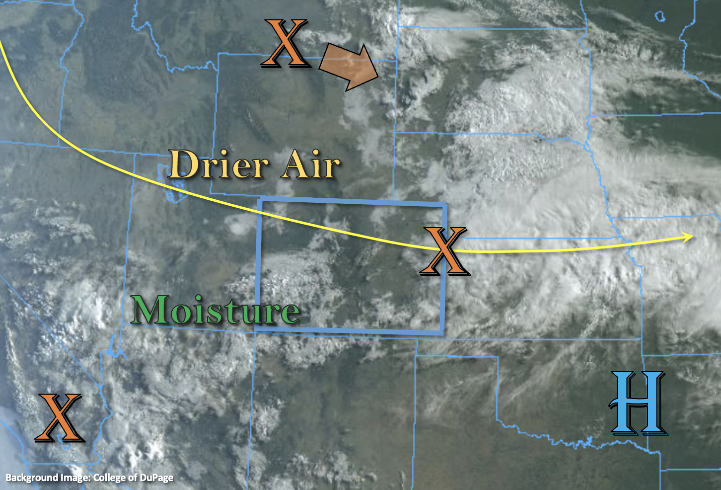
Monsoon moisture remains unaffected across the southern portion of the state with cloud cover and rainfall already occurring over southwest Colorado. Dew points over southeastern Colorado are in the mid 50°Fs to mid-60°Fs, and PW at Grand Junction is around the maximum moving average measured at 1.24 inches. With PW likely over an inch across the southern half of the state and slower steering flows forecast, the stage will be set for another day of heavy rainfall activity. As this moisture pairs with upslope flow, and perhaps some weak mid-level lift, scattered to numerous storms should develop over the high terrains with some spillover anticipated into the adjacent eastern plains. A MODERATE/LOW flood threat has been issued with an increased likelihood for runoff under the stronger storm cores that track over areas with saturated soils. Additional threats include isolated mud flows and debris slides over steeper terrains, rises in local streams/creeks and road/low-lying area flooding.
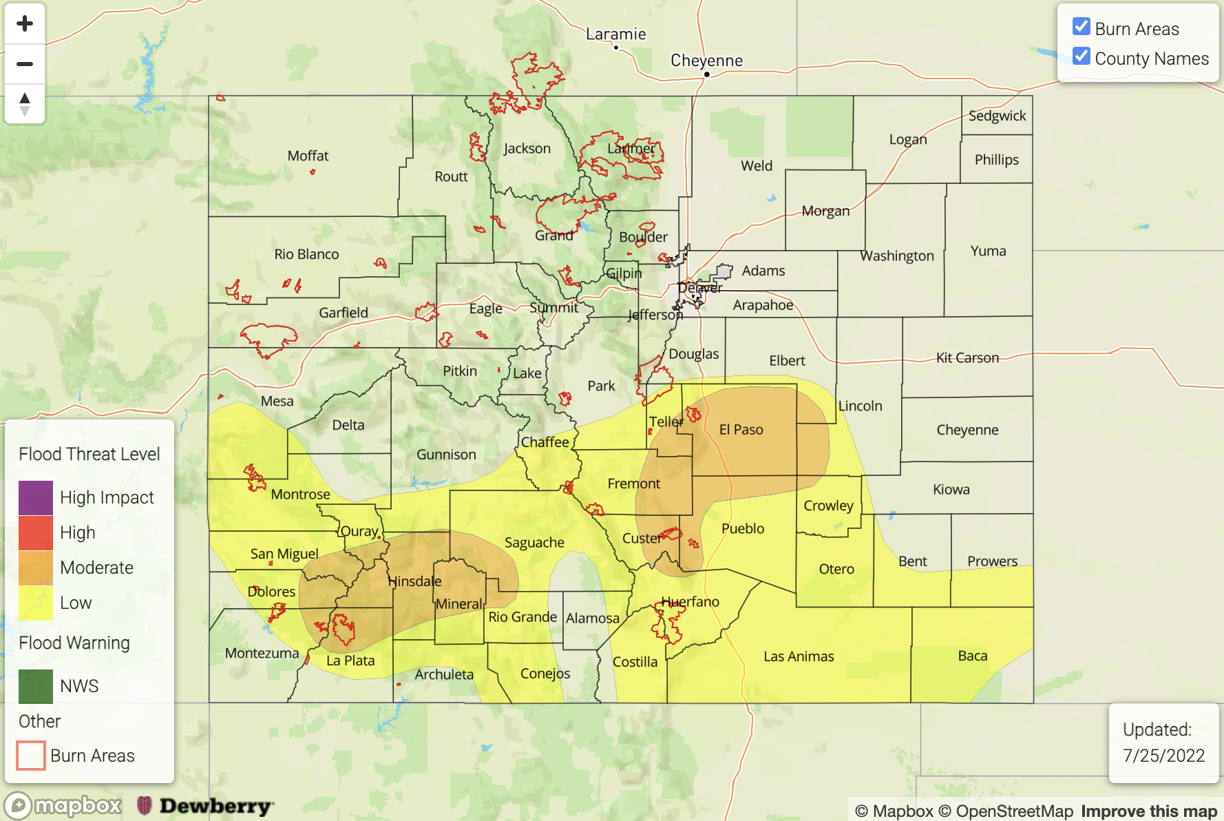
Today’s Flood Threat Map
For more information on today’s flood threat, see the map below. If there is a threat, hover over the threat areas for more details, and click on burn areas to learn more about them. For Zone-Specific forecasts, scroll below the threat map.
Zone-Specific Forecasts:
Central Mountains, Front Range, Southeast Mountains, Raton Ridge, San Juan Mountains, Southwest Slope, Urban Corridor, Palmer Ridge & Southeast Plains:
Scattered to numerous storms are forecast to develop over the high terrains by early afternoon with a couple stronger thunderstorms possible east, which may produce some small hail and strong outflow winds. With longer duration rainfall anticipated over the San Juan Mountains, increased runoff is anticipated as there are likely some saturation soils over the area. Max 3-hour rain rates up to 2.75 inches will be possible, so a MODERATE/LOW flood threat has been issued.
Over the eastern mountains, elevated ridges, and to a lesser extent the far eastern plains, more convective storms are forecast today, which may produce some isolated hail and strong outflow winds in addition to heavy rainfall. Max 1-hour rain rates up to 2 inches and isolated storm totals just under 3 inches will be possible, so a MODERATE/LOW flood threat has been issued.
Flood threats today include road and low-lying area flooding, field ponding, rises in local streams and creeks as well as isolated mud flows and debris slides over steeper terrains. Heavy rainfall activity should come to an end a couple hours after sunset, but some lighter rainfall will likely linger into the overnight and morning hours.
Primetime: 11:30AM to 1AM
Northwest Slope, Grand Valley, Northeast Plains, San Luis Valley & Northern Mountains:
A pleasant day is forecast with afternoon high temperatures near or slightly below normal. Rainfall activity should be limited with a more stable air mass overhead, but a couple isolated weak showers may be possible. This will be most likely to occur over the high terrains over western Colorado or over the far Northeast Plains, but only if a storm or two can break through the cap. Totals should remain under 0.2 inches (west) and 1 inch (east), so flooding is NOT expected.
Primetime: 2PM to 8PM