Issue Date: Sunday, July 24th, 2022
Issue Time: 10:30 AM MDT
Summary:
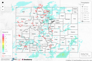
There were high winds yesterday in the northwest quadrant of Colorado, the highest of which was a 57 mph non-thunderstorm wind gust. The Southern Plains also saw some high winds, this time associated with overlapping thunderstorm warnings issued for approximately 6:30-7:45 yesterday evening. There was also a flood advisory issued for the same area. The winds in this area reached up to 75 mph, reported near Lamar, along with up to 0.63” in precipitation. The Northern Plains had some rainfall as well, but only a few hundredths of an inch.
The northern Front Range received many flood advisories from the precipitation yesterday, notably on the Cameron Peak, East Troublesome, and Calwood burn scars. From Fort Collins down to Broomfield, the Urban Corridor received varying amounts of rainfall, from 0.15”- 0.7” depending on location. Many CoCoRaHS reports noted two rounds of storms.
Although it seems there was no flooding near Cameron Peak or Calwood, a debris flow was only reported over Highway 125 on the East Troublesome burn scar. Up to 0.47” was reported on the burn scar near where the debris flow occurred. The highway is closed by approximately 8:30 p.m. yesterday, between Trail Creek and FS Road 112, due to the debris flow and flash flooding. See below for photos from the Grand County Sherriff that show the extent of the damage.
A few photos of the Highway 125 closure due to a mud slide between Trail Creek & FS Rd. 112 on July 23.
Visit https://t.co/mXEnWDxY6Z to stay updated on road closures.#CO125 #COwx #COFlood #COTrip #GrandCounty@ColoradoDOT pic.twitter.com/1UZvLkLgM7
— Grand County Sheriff (@GrandCoSheriff) July 24, 2022
Across the rest of the state there was more rainfall, although quite less than above. Along the southern Urban Corridor, Colorado Springs and Denver saw totals at or below 0.2”. In the San Juan Mountains and south-central portion of the state, highest observations include:
– 0.4” near Gunnison
– 0.53” in Silverton
– 0.39” in Trinidad and Saguache
If you observe flooding in your area, remember to use the “Report a Flood” page to make any flood reports when you can safely do so. For precipitation estimates in our area, check out the map below.
