Issue Date: Saturday, July 23rd, 2022
Issue Time: 9:55AM MDT
— A LOW flood threat has been issued for the Front Range, Central Mountains, Northern Mountains and San Juan Mountains
— Fire-Burn Forecast Summary: 4 burn areas under MODERATE threat; 2 burn areas under LOW threat; click HERE for more info
Several disturbances north of the state can be seen in the water vapor imagery below. These will begin to break down the ridge, which has dominated our weather pattern over the past week+ bringing on and off storm activity to the state. As northwesterly flow begins to take over, cooler statewide temperatures are anticipated; however, the ridge will still be the dominating weather feature through this afternoon helping to produce one more day of hot temperatures. As far as rainfall, the High is pulling in a nice moisture plume over the state (blue shades) and a cool front dropping through eastern Colorado this afternoon should also help increase moisture over the plains. This should keep scattered to numerous showers in the forecast. Small disturbances (smaller orange “X”) embedded in the flow are already helping to produce some light showers and cloud cover over the state this morning, and these should also help produce an uptick in storm coverage this afternoon and evening.
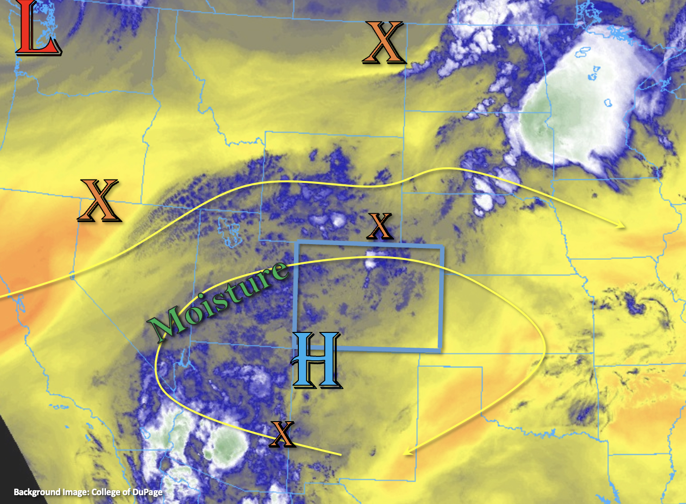
PW at Grand Junction has increased to 0.9 inches with values slightly increasing towards the southern border. Over eastern Colorado, PW is estimated around a quarter of an inch with increasing values towards the eastern border. Surface moisture, outside of the far eastern plains, has increased from this time yesterday, and the cool front should help these eastern Colorado dew points somewhat recover by later in the day. One limiting factor to the heavy rainfall potential today will be faster westerly steering flows, mostly over the northern portion of the state. However, training and multiple rounds of storms along with a nice warm layer helping to increase efficiency should help boost local accumulations over some areas. A LOW flood threat has been issued for areas that this is most likely to occur within the high terrains. In addition to heavy rainfall, the scattered to numerous storms that develop today may also produce lightning, isolated small hail and strong outflow winds.
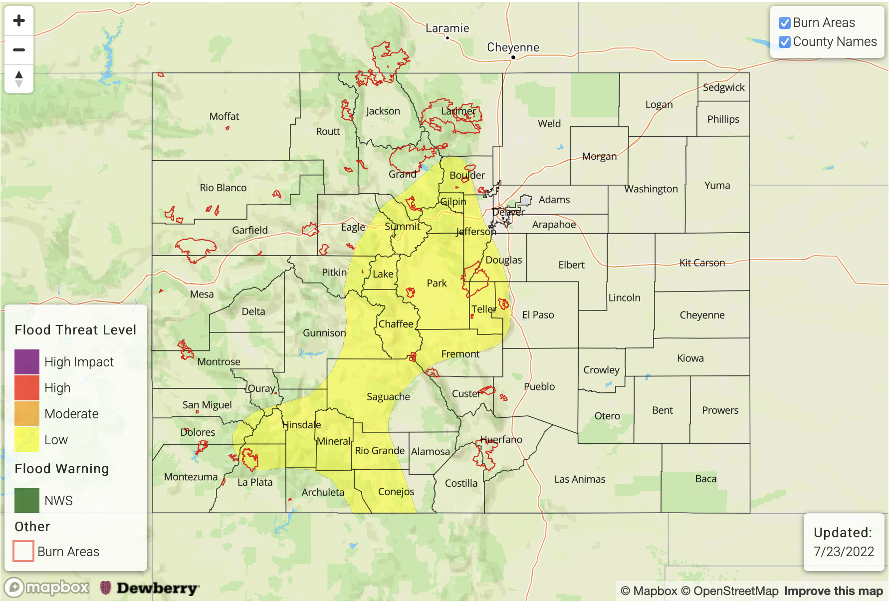
Today’s Flood Threat Map
For more information on today’s flood threat, see the map below. If there is a threat, hover over the threat areas for more details, and click on burn areas to learn more about them. For Zone-Specific forecasts, scroll below the threat map.
Zone-Specific Forecasts:
Central Mountains, Northern Mountains, Front Range & San Juan Mountains:
Numerous to widespread storms are forecast to develop by early afternoon favoring areas near and along the Continental Divide for accumulation. While faster steering flows should somewhat limit the flood threat from any given storm, multiple rounds of storms and isolated areas of training may develop. Max 30-minute rain rates up to 1.25 inches and localized totals up to 1.75 inches will be possible. This could cause isolated mud flows and debris slides as well as road flooding and ponding in low-lying areas. In addition to heavy rainfall, isolated strong storms may produce brief outflow winds, lightning, and small hail. A LOW flood threat has been issued. Lingering showers and weak storms may persist overnight, but the flood threat should end a few hours after sundown as instability drops off.
Primetime: Noon to 11PM
Urban Corridor, Raton Ridge, Southeast Mountains, Palmer Ridge, Southeast Plains & Northeast Plains:
Increasing westerly steering flows should push storms off the mountains and into the adjacent plains by early afternoon with scattered to numerous storms forecast. Additional storms may fire over the eastern plains along the cool front. With a drier boundary layer or limited surface moisture, storms may produce some gusty outflow winds despite some moisture return along the front. Max 30-minute rates up to 0.6 inches (west) and 1-hour rain rates up to 0.9 inches (east) will be possible. In addition to strong winds, isolated hail may be possible, but the severe storm potential remains low. Showers and weak storms may linger through the night with extra lift overhead. Flooding is NOT expected.
Primetime: 1PM to 4AM
Grand Valley, Southwest Slope, San Luis Valley & Northwest Slope:
Isolated to widely scattered storms should stick to the high terrains today with limited spillover into the valleys. Max 30-minute rain rates up to 0.4 inches and isolated storm totals just over 0.5 inches will be possible. Therefore, flooding is NOT expected. A Heat Advisory remains in effect for the Grand Valley, so be sure to drink plenty of water and limit outdoor activities.
Primetime: 1PM to 10PM