Issue Date: 9/3/2015
Issue Time: 8:51 AM
A LOW FLOOD THREAT IS FORECAST FOR PORTIONS OF THE SOUTHWEST SLOPE, SAN JUAN MOUNTAINS, GRAND VALLEY, CENTRAL MOUNTAINS, NORTHERN MOUNTAINS, NORTHWEST SLOPE, AND FRONT RANGE.
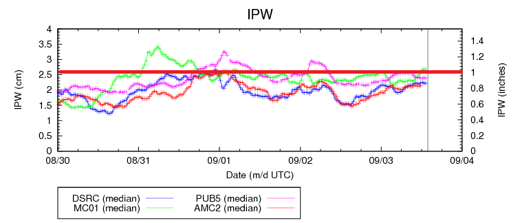
Stuck between an upper-level ridge over the central US and an upper-level ridge over the Pacific Northwest, Colorado will be under the influence of southwesterly flow through today and tonight. A disturbance embedded in the flow will work across the state from southwest to northeast through the afternoon/evening, accompanied by an increase in monsoonal moisture. This will kick off scattered showers and thunderstorms across the mountains, Urban Corridor, and Northeast Plains, with more isolated coverage across the Southeast Plains, Palmer Ridge, and Raton Ridge. Looking at the IPW graph below, the steady increase of moisture since the arrival of yesterday’s monsoonal disturbance is evident, and the pattern will continue today.
The heavy rain threat is a bit higher today as compared to yesterday across the mountains due to increasing moisture and better upper-level support, but steering winds will keep storms moving at a decent clip, limiting the overall flood threat. Lower elevations east of the mountains show a bit of an Inverted-V atmospheric profile, meaning gusty winds and lightning will be the main threats, with rain rates staying below flash flooding thresholds. For more information on rain rates and timing, be sure and check the zone-specific discussions below.
Today’s Flood Threat Map
For more information on today’s flood threat, see the map below (hover over threat areas for more details). For Zone-Specific forecasts, jump below the map.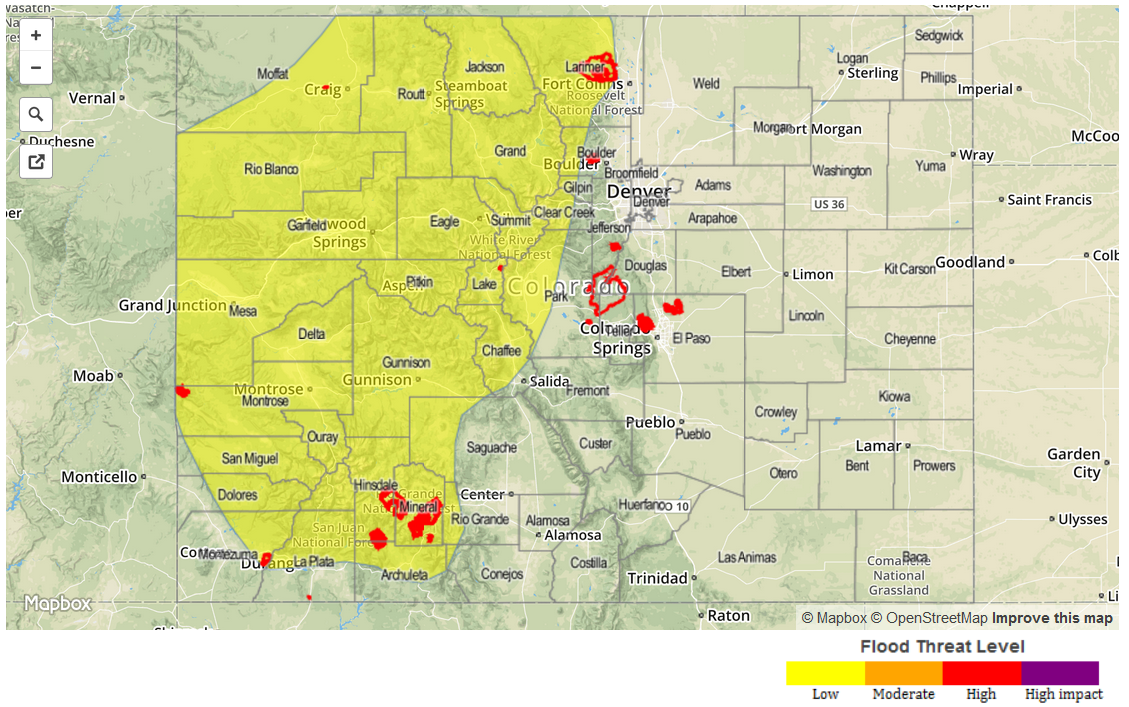
Zone-Specific Forecasts
Urban Corridor, and Northeast Plains:
Scattered showers and thunderstorms are expected, producing mainly gusty winds and lightning, with brief bouts of moderate rainfall. With an inverted-V atmospheric profile in place, maximum rain rates will stay below flash flooding thresholds so no flood threat is warranted. Maximum rain rates will be 0.4-0.7 inches/hour over the Urban Corridor, and 0.-9-1.2 inches/hour over the Northeast Plains.
Timing: 1 PM – 10 PM along the Urban Corridor, and 3 PM – Midnight across the Northeast Plains.
Raton Ridge, Palmer Ridge, and Southeast Plains:
Partly sunny skies will be in place today with the increase in moisture from the monsoonal disturbance. Isolated showers/thunderstorms are expected, with the best opportunity near the mountains. Rain rates will be low, maximizing at 0.3-0.6 inches/hour.
Timing: 2 PM – 9 PM
Front Range, Northern Mountains, Northwest Slope, Central Mountains, San Juan Mountains, Southwest Slope, and Grand Valley:
Scattered-to-widespread showers and thunderstorms expected, capable of locally moderate-to-heavy rainfall. Storm motions will be quick enough to limit the overall flood threat, so only a low flood threat is warranted. Maximum rain rates will be as follows:
Front Range: 0.6-1.0 inches/hour
Northwest Slope, Northern Mountains, and Central Mountains: 1.0-1.8 inches/hour
Grand Valley, Southwest Slope, and San Juan Mountains: 0.8-1.2 inches/hour
Timing: 11 AM – 10 PM, with isolated-to-scattered showers/weak thunderstorms lingering into the early morning hours.
San Luis Valley and Southeast Mountains:
Isolated thunderstorms expected, otherwise a mostly cloudy day is in store. Rain rates will be low, generally in the 0.2-0.4 inches/hour range.
Timing: Noon – 10 PM