Issue Date: Wednesday, July 20th, 2022
Issue Time: 11:15 AM MDT
Summary:
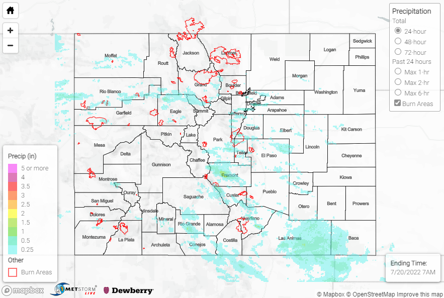
Upper-level ridging remained anchored over the Four Corners region on Tuesday, with hot temperatures and monsoonal moisture return continuing across the state. Orographic lift and diurnal heating combined to produce isolated to scattered showers and storms across the high terrain by early afternoon, with inverted-V soundings again signaling the main severe threat to be gusty outflow winds. Dry air infringing on northern portions of Colorado limited most precipitation to the mountains and foothills along and south of I-70. 45-55 mph gusts were reported with some storms, but no other severe weather reports were received. A Flash Flood Warning was issued for eastern portions of the Pine Gulch burn scar, but no flooding was reported.
Along the southern half of the Front Range and Urban Corridor, amounts generally ranged from 0.20-0.40” where precipitation was observed. Further south from southern portions of the Palmer Ridge across the Southeast Mountains and into the San Juans, isolated amounts of 0.50-1.00” were observed. An automated gauge near Walsenburg measured 0.59”, while CoCoRaHS observers near Walsenburg and Monte Vista measured 0.55” and 0.51”, respectively. Across the southern half of the Northwest Slope and Northern Mountains, gauge observations are sparse but QPE data suggests amounts up to 0.50” were observed. Up to 0.50″ was also observed across southern portions of the Southeast Plains and into the Raton Ridge.
No flooding was reported yesterday. For precipitation estimates in our area, check out the map below.
