Issue Date: Saturday, July 16th, 2022
Issue Time: 10:45 AM MDT
Summary:
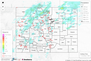
Although central Colorado and the west had quite the eventful day yesterday, it was a bit more calm in the east. The northern half of the plains saw rainfall up to 0.37”, while the Southern Plains stayed quite dry overall. The Central Plains was issued a severe thunderstorm warning yesterday evening, associated with pea sized hail and 55 mph winds- no other damage or severe weather was reported.
To the other side of the state, the Southwest Slope saw heavier rainfall, with street flooding reported in Ouray and some reports of small (0.25”) hail. Placerville and Gunnison had some of the highest precipitation in the area, 1” and 0.81” respectively. The heavy rainfall also caused a debris flow, reported in Sawpit, CO, between MM 77 and 80 on Highway 145. From the Grand Junction WFO:
“Mudslide reported between mile markers 77 and 80 near the Sawpit area on HWY 145. Additionally, had falling rocks and debris. Rocks were the size of cars and water was 2 to 3 feet deep in some spots.”
North in Grand Junction, the heavier precipitation continued. Multiple flood advisories were issued south of and in the city. Many reports of flooding came from within the city, and seemed to be centrally located downtown- reports mentioned several inches of water in streets and backyards, as well as a report of 2 feet of water downtown! Close by to the south in Redlands, water was reported flowing in normally dry ravines. The rain lasted about an hour, according to CoCoRaHS reports, and in total the area saw up to 1.3”. Although this heavy rainfall was near the Pine Gulch burn scar, there doesn’t seem to be any flooding or debris flows reported in that area.
The North and Central mountains got quite a lot of rainfall as well: high winds were reported with the storms in Rifle and Craig, as well as a few more scattered flood advisories. Glenwood Springs had some showers in the late afternoon/evening, saw up to 0.27”. In Yampa, one CoCoRaHS observation noted: “This was the hardest & longest storm we’ve seen in 40+ years at this location. From 6:30 pm – 8:00 we have 1.75″, and then additional .43″ overnight. Amazing!”
While the Urban Corridor hardly saw more than trace- 0.1”, the Front Range had varying totals of 0.1″- 0.93″, including over an inch on the Cameron Peak burn scar. That area was issued several overlapping flood advisories yesterday afternoon and into the night. There were several reports of flash flooding northwest of Estes Park, one report noting “trailers swept into creek”. Another indicated severe flooding at Buckhorn Mountain off Stove Prairie Road. CR 143 was “impassable” at Miller Fork due to water on road, as well. These areas have historically had flooding during past heavy rainfall events; however, the video below gives some insight into just how severe this flooding event was.
Unreal!!!
Flooding in Drake off of streamside Dr.
West of Loveland in Larimer County. #COwx #Flooding
🎥 Jill Smith pic.twitter.com/N8dSszLMc4
— Meteorologist Kody Wilson (@kodythewxguy) July 16, 2022
According to the Larimer County Office of Emergency Management, debris removal and damage assessments will begin today.
No rivers or streams in the state are above flood stage, but the increased precipitation in the mountains has definitely increased discharge farther down the river. The flooding mentioned above occurred west of Loveland Loveland- looking at the hydrograph of the Big Thompson River in Loveland, CO below, we can see the rapid increase from approximately 150 cfs to 800 cfs (via USGS National Water Dashboard.)
If you observe flooding in your area, remember to use the “Report a Flood” page to make any flood reports when you can safely do so. For precipitation estimates in our area, check out the map below.

