Issue Date: Wednesday, July 13th, 2022
Issue Time: 10:45 AM MDT
Summary:
Although the upper-level ridge over Colorado weakened and progressed slightly southward on Tuesday, the day started with sunshine and temperatures remained a few degrees above normal for most locations. Typical diurnal thunderstorm development in the mountains occurred by early afternoon, while a shortwave traversing the state on increasingly northerly flow aloft expanded shower and storm coverage by mid-afternoon into the foothills and eventually the eastern Plains. Lee cyclogenesis and a surface high to our east provided moisture return and upslope flow near the surface, further aiding convective development. Sufficient shear (around 30 knots) allowed enough storm organization to lead to numerous Severe Thunderstorm Warnings, with hail and heavy rain the primary threats.
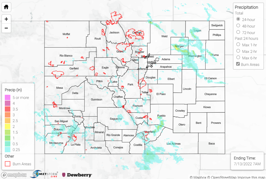
The heaviest rain occurred across the Northeast Plains along and southeast of the I-76 corridor, where amounts up to 1-2” were observed. Gauge observations are sparse, but CoCoRaHS observers reported 0.89” and 0.60” near Woodrow and Flagler, respectively. 1-1.5” hail was also reported in this region. The Southeast Mountains and Raton Ridge also saw heavy rainfall, with amounts of 0.5-1.5”. An automated station near La Veta measured 1.07”, while a CoCoRaHS observer near Walsenburg measured 0.73”. Up to 1.75” hail was reported near Trinidad, with a CoCoRaHS observer reporting minor street flooding 1 mile west of town.
Elsewhere in the state, the Front Range generally saw T-0.25”, although some higher amounts up to 0.50” were observed, including 0.42” south of Fort Collins. The Southwest Slope observed up to 1” of rainfall, with an automated station near Towaoc measuring 0.89”.
Flash Flood Warnings were issued for south-central Chaffee County and once again the Spring Creek burn scar, with no flooding reported. Two Flood Advisories were issued for portions of the Southwest Slope, and another Flood Advisory was issued for southeastern portions of the Cameron Peak burn scar, but no flooding was reported at any of these locations.
On the interesting side of yesterday’s weather, a heat burst was recorded near Wray:
Ongoing heat burst in Wray, CO this evening (Tuesday July 12, 2022). As of 10:35 pm MDT, the temperature was 86°F, the dewpoint was 34°F, and the RH was 16%. #COwx #KSwx #NEwx pic.twitter.com/Un3eek42Bp
— NWS Goodland (@NWSGoodland) July 13, 2022
Also check out this awesome video from one of the storms in the Northeast Plains at sunset:
That may be the last storm of my short lived Colorado adventure for the foreseeable future, but good grief that was insane ! Sunset, full moon, cg barrage, rainbows, hail. Thank you ma nature 🙏🏼 #cowx pic.twitter.com/FLTXHihLPb
— Greg Travers (@Gregt041) July 13, 2022
If you observe flooding in your area, remember to use the “Report a Flood” page to make any flood reports when you can safely do so. For precipitation estimates in our area, check out the map below.
