Issue Date: Friday, July 8th, 2022
Issue Time: 11:00 AM MDT
Summary:
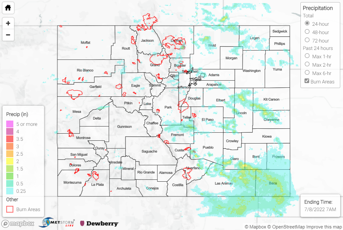
The extensive ridge across the southern U.S. amplified slightly westward on Thursday, advecting in drier air from the southwest and yielding lower precipitable water values. Nonetheless, with sufficient instability remaining and a weak cap, thunderstorms developed along the Continental Divide and the Palmer Ridge by mid-afternoon. Weak upper-level support limited most convection to the eastern half of the state, as storms tracked southeastward off the high terrain and out in the Plains through the remainder of the day. Lower moisture and less shear limited the severe weather threat compared to Wednesday; the only storm report of the day was for nickel-sized hail near Colorado City.
A Flash Flood Warning was issued for southeastern portions of the Cameron Peak burn scar, with minor flooding reported along a private road near Masonville; this flooding was due to heavy rain with no debris flow reported. Another Flash Flood Warning was issued for southeastern Larimer County, with flash flooding reported down Cedar Creek near Cedar Cove. Emergency managers relayed reports of a debris dam behind a bridge along a neighborhood access road, with 15 residents temporarily stranded; no injuries were reported. Additional Flash Flood Warnings were issued for the Calwood burn scar, East Troublesome burn scar, and portions of Cheyenne County, with no flooding reported; a Flood Advisory near Limon also saw no flooding reported.
Portions of the Northern Mountains and Front Range saw up to 1-1.5” inches of rain under the most intense cells. The Urban Corridor saw generally 0.25-0.50”, with localized amounts up to 1”. The heaviest rain across the state fell over the Northeast Plains, eastern Palmer Ridge, and Southeast Plains, where several swaths of 1-2” of rain were observed; localized totals of 1.5-2.5” were observed near Colorado City and across southern Otero/Bent Counties. For the western half of the state, rainfall was isolated with amounts generally less than 0.25”; a cell near the Mesa/Delta County line dropped localized amounts up to 1”.
Some notable rainfall reports along the Front Range include:
• 0.62” 4.7 miles SSE of Idaho Springs
• 0.62” 3.2 miles NNW of Drake (near the report of a debris dam)
Noteworthy rainfall reports across the Plains and Palmer Ridge include:
• 2.90” 2.3 miles SE of Springfield
• 2.50” 1.6 miles W of Colorado City
• 1.90” 17.5 miles S of La Junta
If you observe flooding in your area, remember to use the “Report a Flood” page to make any flood reports when you can safely do so. For precipitation estimates in our area, check out the map below.
