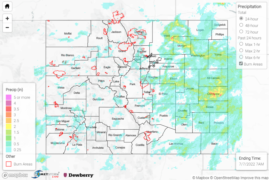
Issue Date: Thursday, July 7th, 2022
Issue Time: 11:45 AM MDT
Summary:
Wednesday was an exceptionally active weather day, with showers and thunderstorms producing no shortage of all modes of severe weather across the state. Moisture was on the increase yesterday across the lower elevations while the influx of monsoonal moisture continued aloft, providing precipitable water values 150-200% of normal. An early morning disturbance moved north of the state while subsidence in its wake scoured out low clouds, allowing plentiful sunshine and the erosion of convective inhibition (CIN) by noon. With plentiful moisture and no cap, an upper-level shortwave and upslope surface flow combined to trigger widespread storms in the mountains/over the Palmer Ridge.
Storms at first struggled to move off the high terrain, but soon became organized into supercells/multi-cell clusters (thanks to ample shear) and moved out into the Plains, where they produced heavy rain, severe winds, hail, and a few tornadoes. By late evening, the storms grew upscale into a line while departing the state to the east.
The WFOs issued a plethora of Severe Thunderstorm Warnings and Tornado Warnings, most notably across the eastern half of the state. Two tornadoes were reported: one tornado along U.S. Highway 50 near the Bent/Otero County line, and another tornado east of Fort Morgan with reports of tree damage and downed power lines. Thunderstorm wind gusts up to 76 mph were reported in both Lamar and La Junta, while hail up to 1” was reported across the state.
Downed power pole from tor warned storm just went through CR25 and CR R east of Ft Morgan. Morgan County. #cowx pic.twitter.com/eldWtJwRdZ
— Frontier Views | Jim Hobson (@FrontierViews) July 6, 2022
The main weather story with yesterday’s storms was the heavy rainfall, which prompted the issuance of numerous Flash Flood Warnings and Flood Advisories. A Flash Flood Warning was issued for north-central, east-central, and southeast portions of the Cameron Peak burn scar, and Larimer County officials reported flooding west of Rustic. Other warnings were issued for north-central Boulder County (including the Calwood burn scar), central Chaffee County, and northeast El Paso County, but no flooding was reported. Flash Flood Warnings for portions of east-central San Miguel, southern Crowley, and central Otero Counties encompassed the most severe flooding in the state: a mudslide was reported 5 miles west of Telluride covering State Highway 145, while U.S. Highway 50 near La Junta was closed for water running across the road and under an overpass. Check out the image below from the Colorado State Patrol:
Hwy 50 at Hwy 71 had some water still running across the roadway. The ditches are overflowing. Watch for tree branches on roadways in La Junta and Rocky Ford. pic.twitter.com/pt0mkmE99s
— CSP La Junta&Lamar (@CSP_LaJunta) July 7, 2022
In terms of rainfall amounts, 1-2” was widespread across much of the Northeast Plains, Palmer Ridge, and Southeast Plains. Portions of the Front Range saw up to 1.5” of rain, while amounts up to 0.5” (including near the mudslide west of Telluride) were widely scattered across the western half of the state. The heaviest rain fell in two general locations: Weld/Morgan Counties, were 2.5-3.5” of rain was observed, and Kit Carson/Cheyenne Counties south of I-70, where 3-4” of rain was observed!
Some impressive rainfall totals across the Plains include:
• 3.79” in Rocky Ford
• 3.25” in Cheyenne Wells
• 3.22” in Pawnee National Grasslands
• 2.54” 2.9 miles ESE of Rocky Ford
• 2.29” 5 miles SSE of Brush
Some impressive rainfall totals at high elevations in the mountains include:
• 2.06” 6.6 miles WNW of Arvada
• 1.35” at Georgetown Lake
• 1.22” 6.2 miles N of Black Hawk
• 1.20” in Nederland
The station in Rocky Ford measured 3.36” of its 24-hour total in just one hour! This extreme rainfall rate has an estimated ARI of over 350 years, per NOAA Atlas 14 data!
If you observe flooding in your area, remember to use the “Report a Flood” page to make any flood reports when you can safely do so. For precipitation estimates in our area, check out the map below.
