Issue Date: Wednesday, July 6th, 2022
Issue Time: 11:15 AM MDT
Summary:
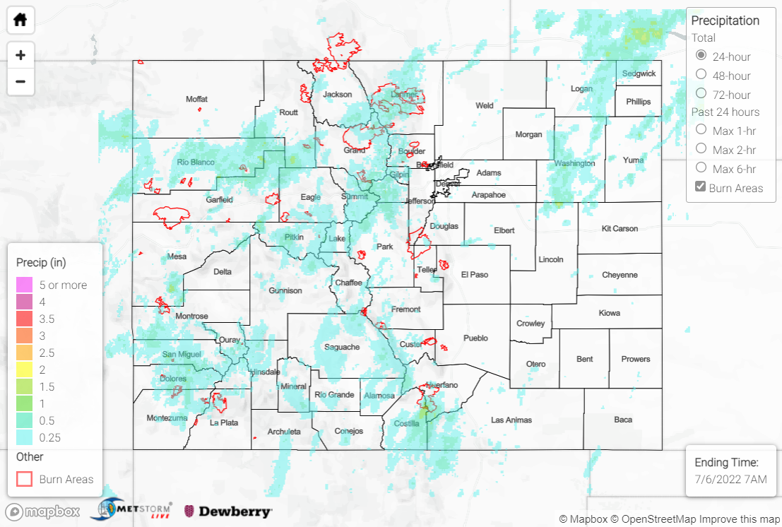
Rain was widespread across the state yesterday. South-central Colorado received above 0.7” in many areas, with many observations across the area in the 0.2”-0.5” range. Moving north, the Urban Corridor saw most observations coming in under 0.05”, but saw a few observations up to 0.22” southwest of Denver and near Greeley.
There wasn’t much rain in the Northwest Slope, but the rest of the western half of the state received rainfall to make up for it. Grand Junction saw up to 0.14”, while Glenwood Springs and Crested Butte received up to 0.4” from afternoon thunderstorms. There was an additional Flood Advisory issued east of Glenwood Springs on the Grizzly Creek burn scar. Although I-70 was preemptively closed, no flooding was reported. Pagosa Springs and other southwestern areas also received afternoon/evening showers, with varying precipitation amounts from T- 0.71”.
The Eastern Plains saw much less rain yesterday, with most reports coming in under 0.06″, although Logan County in the Northern Plains saw up to 0.5”. This was associated with a severe thunderstorm warning AND a tornado warning that was issued yesterday afternoon. A tornado was confirmed soon after, along with quarter-sized hail.
The Front Range received higher rainfall totals, however- 0.78” north of Estes Park, 1.06” east of Kremmling, 0.52” near Dumont were a few of the higher observations. There was a myriad of flood advisories overlapping across the Rocky Mountains yesterday due to these storms, with two near Grand County where the East Troublesome burn scar is located. As noted above, there was a debris flow in this area across CO-125 once again. The flood advisory stayed in effect until 4:30 p.m. yesterday- precipitation estimates in this area include observations up to 0.54”. See below for closure and debris flow details.
Happening Now on 7/5: Hwy 125 is closed between FS Rd. 730 & US 40 (Willowcreek Pass) from Mile Point 21.5 to Mile Point 0. Expect delays due to a mud slide. Road only open to locals.
➡️https://t.co/mXEnWDgmIp to stay updated on road closures @ColoradoDOT
#CO125 #GrandCounty pic.twitter.com/TPBxbBiYW4
— Grand County Sheriff (@GrandCoSheriff) July 5, 2022
For precipitation estimates in our area, check out the map below.
