Issue Date: Friday, July 1st, 2022
Issue Time: 11:00 AM MDT
Summary:
Yesterday was the last day of June and it officially feels like North American Monsoon season is here! The morning began with widely scattered storms and showers over the Northwest Slope, Grand Valley, and Northern Mountains associated with a plume of monsoonal moisture. Eastward storm motion moved showers onto the Front Range, Urban Corridor, and Northeast Plains as the morning progressed. By early afternoon, daytime heating combined with that available moisture sparked rounds of storms, which began building in the Grand Valley, Northwest and Southwest Slopes, Central and San Juan Mountains, as well as the lingering storms on the Urban Corridor, Palmer Ridge, and Northeast Plains. As afternoon turned to early evening, there were numerous showers over much of the state of Colorado with the exception of the Southwest Slope.
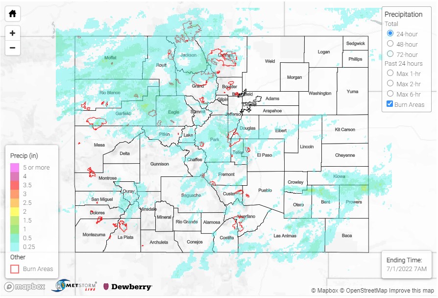
Rounds of rainfall prompted several flood advisories to be issued for Western Colorado including San Miguel, Eagle, Ouray, Montrose, Rio Blanco, Moffat, Garfield, and Mesa Counties, with the largest threat of arroyo and small stream flooding from excessive rainfall. QPE and gauge observations across the region support widespread 0.25-0.50 inch rainfall with pockets of higher accumulations under localized convection. In addition to the advisories, a flash flood warning was issued for Chaffee County including Cottonwood Pass near Buena Vista. A MesoWest gauge north of Cottonwood Pass picked up 0.73 inches of rain yesterday in about 4 hours between 1:00 and 5:00 pm. Thankfully, no flooding has been reported so far.
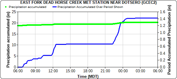
This was another day of substantial rainfall on the Grizzly Creek scar in Glenwood Canyon. A USGS gauge on the scar, East Fork of Dead Horse Creek, received over 1.30 inches of rain in 24-hours yesterday as seen in the hyetograph below. Rainfall was spread out over the course of the day into two fairly low-intensity pulses from 6 am until after noon and then again during the overnight hours from 10 pm to before 2 am, which minimized flood and debris flow risk in the canyon. At the same gauge, the 2-day total of 2.43 inches is just below the 25-year ARI value of 2.51 inches – impressive rainfall to not cause any flooding in this particularly sensitive area.
Yesterday’s storms were generally benign for most of the state, with the exception of a severe thunderstorm on the Southeast Plains extending along the US-50 corridor from La Junta to Holly on the Kansas border. The main threat from the severe thunderstorm was high winds, and there were a couple 62-mph thunderstorm wind gusts observed. Rainfall was also impressive with a total of 1.00 inch from a CoCoRaHS observer north of La Junta, who also reported hail. 0.81 inches was reported in Las Animas and 0.54 inches in Lamar, also from CoCoRaHS observers.
Storms across Colorado began drying out and lifting overnight. There was no flooding reported yesterday. For precipitation estimates in our area, check out the map below.

