Issue Date: Thursday, June 30th, 2022
Issue Time: 10AM MDT
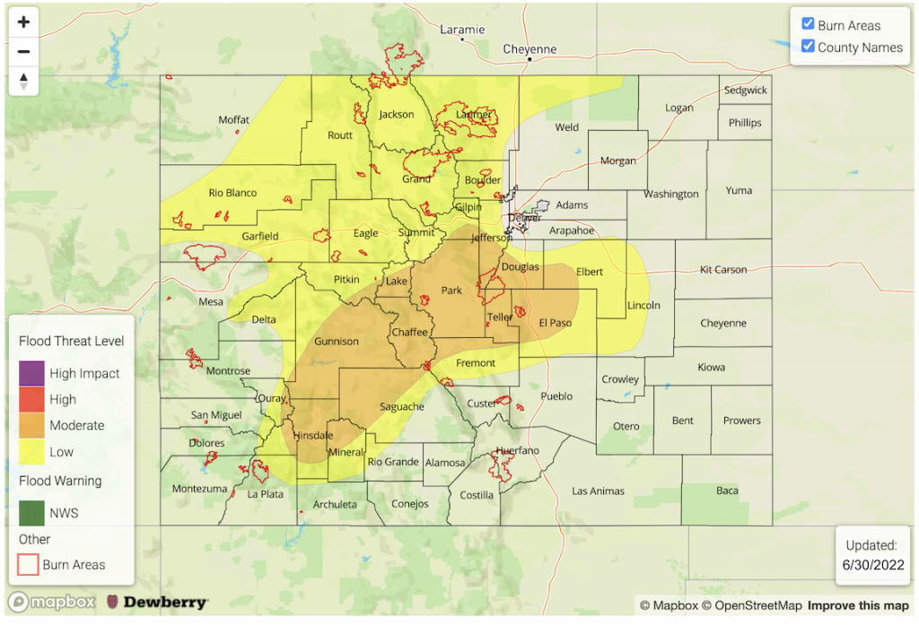
— A MODERATE flood threat has been issued portions of the San Juan Mountains, Central Mountains, Front Range, Urban Corridor and Palmer Ridge
— A LOW flood threat has been issued for the Northern Mountains and portions of the Grand Valley and Northwest Slope
— Fire-Burn Forecast Summary: 5 burn areas under MODERATE threat, 4 burn areas under LOW threat; click HERE for more info
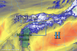
This morning there are some ongoing, moderate intensity showers over northwestern Colorado and the northern Front Range. The water vapor imagery below shows the moisture source for these weak storms coming up from the south. With westerly flow aloft around the High continuing today, moisture across the state should be on the rise. PW this morning at Grand Junction and Denver illustrates this point with nearly saturated profiles from about 3km upwards. Their respective values were measured at 1.03 inches and 0.81 inches, which are both above average for this time of year. This indicates that rain rate intensities should be higher today with the scattered storms forecast over the mountains and higher terrains, which will have some spill over into the adjacent, eastern plains.
A jet streak to our north should help keep storms moving relatively quickly from west to east across the northern tier of the state, but local, heavy downpours will still be possible and multiple rounds of rainfall may increase local totals. This is especially true by later this evening as steering flows should begin to decrease with the jet streak lifting north. For this reason, a LOW flood threat has been issued. Further south, storm motion should be a bit slower, and some training storms will be possible. Both of these factors should increase rainfall totals and up the potential for flooding issues. Thus, a MODERATE flood threat has been issued for this region. As storms spill into the adjacent plains with westerly steering flows aloft, there is a better likelihood for decent accumulations with the upturn in moisture and mid-level energy today. Stronger thunderstorms may still produce brief, strong winds and severe hail. Extra moisture convergence is likely over the elevated Palmer Ridge area, so the MODERATE threat has been extended into the area. Flood threats today include ponding in low-lying areas/intersections, increased runoff and mud flows/debris slides over the steeper terrains. The flood threat continues until a couple of hours after the sun sets and instability drops off.
Today’s Flood Threat Map
For more information on today’s flood threat, see the map below. If there is a threat, hover over the threat areas for more details, and click on burn areas to learn more about them. For Zone-Specific forecasts, scroll below the threat map.
Zone-Specific Forecasts:
Front Range, Central Mountains, San Juan Mountains, Urban Corridor & Palmer Ridge:
Max 1-hour rain rates up to 1.5 inches will be possible today with slow moving and training storms that develop. Local totals just under 2 inches will be possible if a storm lingers for over an hour, so a MODERATE/LOW flood threat has been issued. Stronger storms may also produce some severe hail and outflow winds. These stronger severe storms will be most likely over the adjacent plains though smaller hail will be possible with the mountain storms. Flood threats include road/low-lying intersection flooding, field ponding and mud flows/debris slides over steeper terrains.
Primetime: Ongoing to 12PM
Northern Mountains, Northwest Slope & Grand Valley:
Storms should have quicker movement this morning and afternoon with slower steering flows forecast by this evening. Although rainfall is occurring now, a second set of rainfall is forecast to develop late this afternoon and into the evening hours. Max 30-min rate rates up to 1 inch with local totals up to 1.6 inches will be possible today. This could cause mud flows/debris slides and increased runoff over steeper terrains. A LOW flood threat has been issued.
Primetime: Ongoing to 11PM
Southwest Slope, San Luis Valley, Southeast Mountains, Raton Ridge, Northeast Plains & Southeast Plains:
Isolated rainfall is forecast for the Southwest Slope over the elevated terrains as well as for the Southeast Mountains and Raton Ridge. Max 1-hour rain rates up to 0.75 inches (west) and 0.5 inches (east) will be possible. Some storms may spill into the San Luis Valley with isolated totals up to 0.2 inches possible. More isolated storms will be possible over the Northeast and Southeast Plains with the best accumulation over central and northern Colorado near the Ridges. Max 1-hour rain rates up to 1.25 inches will be possible over these areas. Flooding is NOT expected for these areas today.
Primetime: 12PM to 10PM

